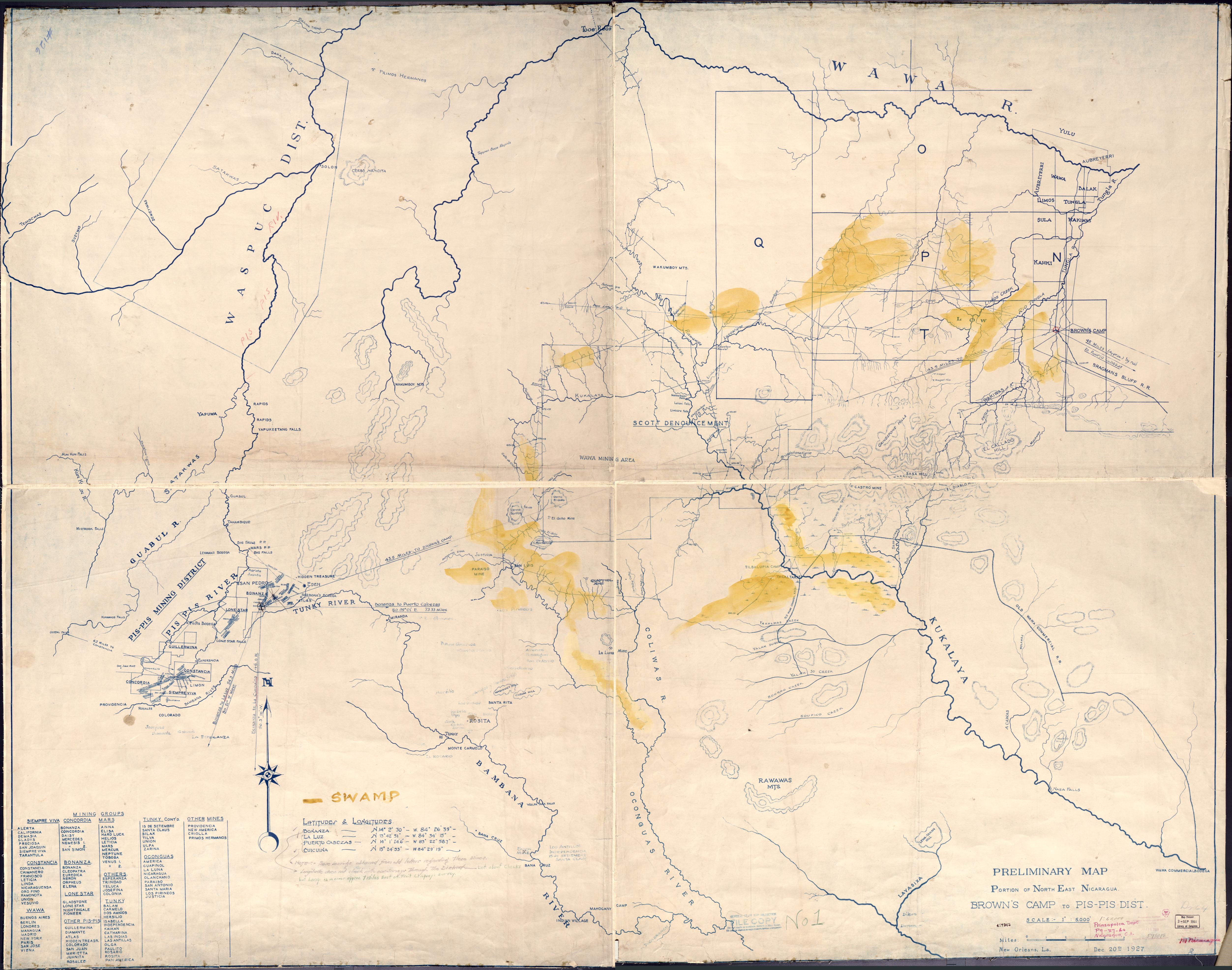
Dispossesions in the Americas

Dispossesions in the Americas

  • Home
  • Explore
  • About
  • Authors
  • Art
  • Bodies
  • Curricula
  • Cultural Heritage
  • Maps
  • Territories
Back to Explore
Map 1927

Preliminary Map;portion of north east [sic] Nicaragua: Brown's Camp to Pis Pis District.

    Published: 1927

    • Download Image

    Peoples

    • INDIAN
    • WAWA

    Citation

    Preliminary Map;portion of north east [sic] Nicaragua: Brown's Camp to Pis Pis District. New Orleans: [s.n] 1927.Library of Congress Geography and Maps Division. G4851.H1 1927 .P7. https://www.loc.gov/item/2006636639/AccessedJuly252023.

    • Download Image

    Reading in Spanish

    Map 1927

    Preliminary Map;portion of north east [sic] Nicaragua: Brown's Camp to Pis Pis District.

      Published: 1927

      • Download Image
      • Download Image

      Reading in Portuguese

      Map 1927

      Preliminary Map;portion of north east [sic] Nicaragua: Brown's Camp to Pis Pis District.

        Published: 1927

        • Download Image

        Peoples

        • INDIAN
        • WAWA

        Citation

        Preliminary Map;portion of north east [sic] Nicaragua: Brown's Camp to Pis Pis District. New Orleans: [s.n] 1927.Library of Congress Geography and Maps Division. G4851.H1 1927 .P7. https://www.loc.gov/item/2006636639/AccessedJuly252023.

        • Download Image

        Related Content

        Carte des Embouchûres des Rivières d'Ouyapoque et d'Aprouague et de la distance que contient le chemin parterre qu'a fait Monsieur de Régis au mois d'août 1738 .

        Carte des Embouchûres des Rivières d'Ouyapoque et d'Aprouague et de la distance que contient le chemin parterre qu'a fait Monsieur de Régis au mois d'août 1738 .

        Map 1738
        Jujeñazo Vol. 2084 con la "Vendedora de cultura" [Jujeñazo Vol. 2084 featuring the ‘Culture Seller’]

        Jujeñazo Vol. 2084 con la "Vendedora de cultura" [Jujeñazo Vol. 2084 featuring the ‘Culture Seller’]

        Artwork
        PUEBLO MASHCO PIRO

        PUEBLO MASHCO PIRO

        Map 2021
        Territorios con Ocupación Actual, Tradicional y Pública Ley 26.160

        Territorios con Ocupación Actual, Tradicional y Pública Ley 26.160

        Map 2023
        Territorios indígenas de Guatemala antes de 1524

        Territorios indígenas de Guatemala antes de 1524

        Map 1523
        YBYTOSO ISHIR

        YBYTOSO ISHIR

        Map 2015
        Territorio Rama y Kriol: Mapa de Zonas Territoriales. Three Zones proposed by the PADA to ensure a sustainable future for the communities of Rama and Kriol

        Territorio Rama y Kriol: Mapa de Zonas Territoriales. Three Zones proposed by the PADA to ensure a sustainable future for the communities of Rama and Kriol

        Map 2000
        MAPA LINGÜÍSTICO DEL PAIS

        MAPA LINGÜÍSTICO DEL PAIS

        Map 2009 - 2010

        Dispossessions in the Americas

        A project by

        University of Pennsylvania

        Copyright 2024

        With support from

        Mellon Foundation

        Site design & development

        Element 84

        Art Credits

        Preliminary Map;portion of north east [sic] Nicaragua: Brown’s Camp to Pis Pis District. New Orleans: [s.n] 1927.Library of Congress Geography and Maps Division. G4851.H1 1927 .P7. https://www.loc.gov/item/2006636639/AccessedJuly252023.

        Site Pages

        • Home
        • Explore
        • About
        • Authors
        • Art
        • Bodies
        • Curricula
        • Cultural Heritage
        • Maps
        • Territories