Dispossesions in the Americas

Dispossesions in the Americas

  • Home
  • Explore
  • About
  • Authors
  • Art
  • Bodies
  • Curricula
  • Cultural Heritage
  • Maps
  • Territories
Back to Explore
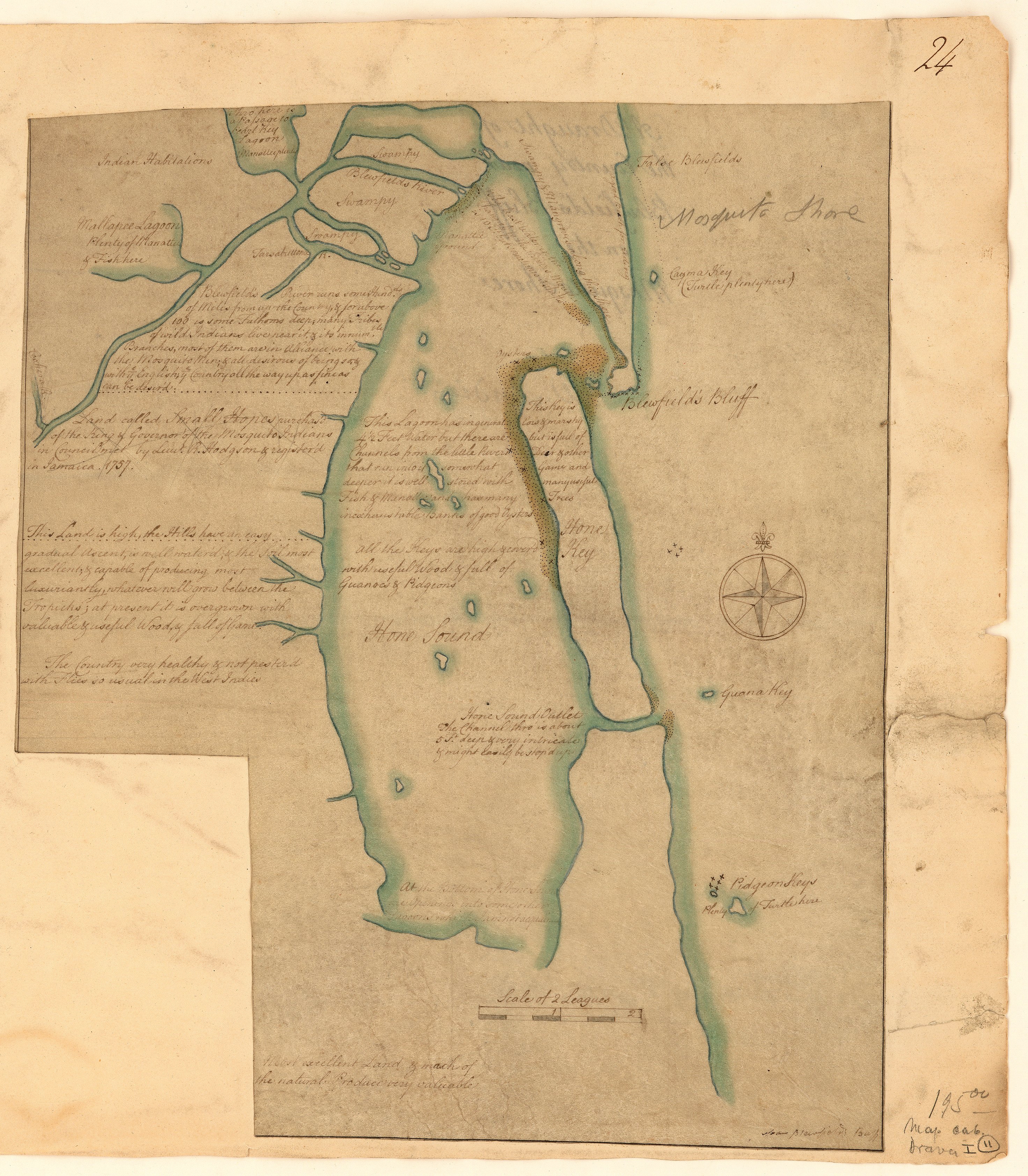
Map 1757

A draught of the country near Blewfields Bluff on the Mosquito Shore

    Published: 1757

    • Download Image

    Peoples

    • MOSQUITOS
    • INDIANS

    Citation

    A draught of the country near Blewfields Bluff on the Mosquito Shore. 1757. John Carter Brown Map Collection. C-6713. File Name: C-6713-000. https://jcb.lunaimaging.com/luna/servlet/detail/JCBMAPS~1~1~6420~115902733:A-draught-of-the-country-near-Blewf?qvq=q:Nicaragua;lc:JCBMAPS~2~2;JCBMAPS~3~3;JCB~1~1;JCB~3~3;JCBBOOKS~1~1;JCBMAPS~1~1&mi=11&trs=66#
    • Download Image

    Reading in Spanish

    Map 1757

    A draught of the country near Blewfields Bluff on the Mosquito Shore

      Published: 1757

      • Download Image
      • Download Image

      Related Content

      NACIONALIDADES INDÍGENAS DEL ECUADOR

      NACIONALIDADES INDÍGENAS DEL ECUADOR

      Map 1988
      Carte de la Neustrie dressé ainsi que la carte générale;d'aprés les cartes de Jn. Purdy;celles de Th Jefferys;corrigées;etc.;etc/

      Carte de la Neustrie dressé ainsi que la carte générale;d'aprés les cartes de Jn. Purdy;celles de Th Jefferys;corrigées;etc.;etc/

      Map 1830
      GRUPOS ETNOLINGÜÍSTICOS DE OAXACA

      GRUPOS ETNOLINGÜÍSTICOS DE OAXACA

      Map 1999 - 2002
      Map of the basin of La Plata : based upon the results of the expedition under the command of Thos. J. Page;U.S. Navy;in the years 1853;-'54;-'55;& 56 and of the adjacent countries

      Map of the basin of La Plata : based upon the results of the expedition under the command of Thos. J. Page;U.S. Navy;in the years 1853;-'54;-'55;& 56 and of the adjacent countries

      Map 1853 - 1856
      PUEBLO VACACOCHA

      PUEBLO VACACOCHA

      Map 2021
      CARTE DU THÉÂTRE DE LA GUERRE ENTRE LE BRÉSIL, LA CONFÉDÉRATION ARGENTINE, LA RÉPUBLIQUE DE L'URUGUAY & LE PARAGUAY

      CARTE DU THÉÂTRE DE LA GUERRE ENTRE LE BRÉSIL, LA CONFÉDÉRATION ARGENTINE, LA RÉPUBLIQUE DE L'URUGUAY & LE PARAGUAY

      Map 1864 - 1865
      Constitución de Territorio Mapuche  1598-1604.

      Constitución de Territorio Mapuche 1598-1604.

      Map 1598 - 1604
      Carte nouvelle de la France Equinoctiale

      Carte nouvelle de la France Equinoctiale

      Map 1665

      Dispossessions in the Americas

      A project by

      University of Pennsylvania

      Copyright 2024

      With support from

      Mellon Foundation

      Site design & development

      Element 84

      Art Credits

      A draught of the country near Blewfields Bluff on the Mosquito Shore. 1757. John Carter Brown Map Collection. C-6713. File Name: C-6713-000. https://jcb.lunaimaging.com/luna/servlet/detail/JCBMAPS~1~1~6420~115902733:A-draught-of-the-country-near-Blewf?qvq=q:Nicaragua;lc:JCBMAPS~2~2;JCBMAPS~3~3;JCB~1~1;JCB~3~3;JCBBOOKS~1~1;JCBMAPS~1~1&mi=11&trs=66#
      Site Pages

      • Home
      • Explore
      • About
      • Authors
      • Art
      • Bodies
      • Curricula
      • Cultural Heritage
      • Maps
      • Territories