Citation
Comisión Nacional para el Desarrollo de los Pueblos Indígenas. Regiones indígenas de México. Publication no. 330.972. 2006. https://www.gob.mx/cms/uploads/attachment/file/35735/cdi-regiones-indigenas-mexico.pdf.
![[Carte de la Guyane depuis le Marony jusqu'au Yary]](https://dnet8ble6lm7w.cloudfront.net/maps/FGU/FGU0046.jpeg)
[Carte de la Guyane depuis le Marony jusqu'au Yary]
Map 1766![La noche, la lora y los muertos [The Night, the Parrot and the Dead]](https://dnet8ble6lm7w.cloudfront.net/art_sm/AARG023.png)
La noche, la lora y los muertos [The Night, the Parrot and the Dead]
Artwork
MAPA N. 1 DISTRIBUCIÓN DE LAS AGRUPACIONES Y LENGUAS INDÍGENAS EN 1500
Map 1500![Jardín de aclimatación de blancos [White Acclimatization Garden]](https://dnet8ble6lm7w.cloudfront.net/art_sm/ACHI018.png)
Jardín de aclimatación de blancos [White Acclimatization Garden]
Artwork
Guyane française. Carte géographo-géologique, dressée d'après les reconnaissances faites de 1867 à 1878 par le bureau du cadastre de Cayenne.
Map 1867 - 1878
ESTADOS UNIDOS DO BRAZIL
Map 1902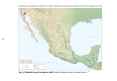
Población es-pei (cucupá) en 2010
Map 2010
Hecatombe II
Artwork