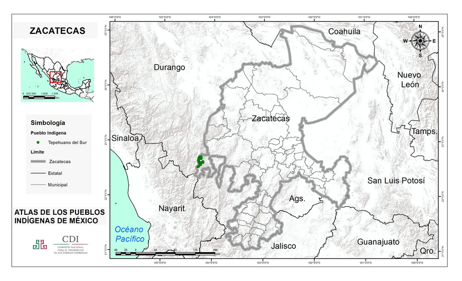
Dispossesions in the Americas

Dispossesions in the Americas

  • Home
  • Explore
  • About
  • Authors
  • Art
  • Bodies
  • Curricula
  • Cultural Heritage
  • Maps
  • Territories
Back to Explore
Map 2015

ZACATECAS

  • INSTITUTO NACIONAL DE LOS PUEBLOS INDIGENAS

  • Download Image

Peoples

  • TEPEHUANO DEL SUR

Citation

Instituto Nacional de los Pueblos Indígenas. "Distribución por Entidad Federativa." Atlas de los pueblos indígenas de México. http://atlas.inpi.gob.mx/distribucion-por-entidad-federativa/.

  • Download Image

Reading in Spanish

Map 2015

ZACATECAS

  • INSTITUTO NACIONAL DE LOS PUEBLOS INDIGENAS

  • Download Image
  • Download Image

Related Content

Reducción del territorio Barí 1950 -1970

Reducción del territorio Barí 1950 -1970

Map 1950 - 1970
CARTA ETNICA DEL GRAN CHACO EN EL UMBRAL DEL S.XX

CARTA ETNICA DEL GRAN CHACO EN EL UMBRAL DEL S.XX

Map 1875 - 1935
Major Places of Mayo Settlement

Major Places of Mayo Settlement

Map 1969
PUEBLO CHONTAL DE OAXACA

PUEBLO CHONTAL DE OAXACA

Map 2020
TITLED INDIGENOUS TERRITORIES (TIOCs)  IN THE BOLIVIAN INTER-ANDEAN VALLEYS BY 2011

TITLED INDIGENOUS TERRITORIES (TIOCs) IN THE BOLIVIAN INTER-ANDEAN VALLEYS BY 2011

Map 2011
QUINTANA ROO

QUINTANA ROO

Map 2015
San Juan Baptista, San Luys Tezontla y Santa María Nochtongo. Oaxaca, 1579

San Juan Baptista, San Luys Tezontla y Santa María Nochtongo. Oaxaca, 1579

Map 1579
Risaralda

Risaralda

Map 2012

Dispossessions in the Americas

A project by

University of Pennsylvania

Copyright 2024

With support from

Mellon Foundation

Site design & development

Element 84

Art Credits

Instituto Nacional de los Pueblos Indígenas. “Distribución por Entidad Federativa.” Atlas de los pueblos indígenas de México. http://atlas.inpi.gob.mx/distribucion-por-entidad-federativa/.

Site Pages

  • Home
  • Explore
  • About
  • Authors
  • Art
  • Bodies
  • Curricula
  • Cultural Heritage
  • Maps
  • Territories