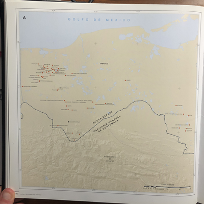
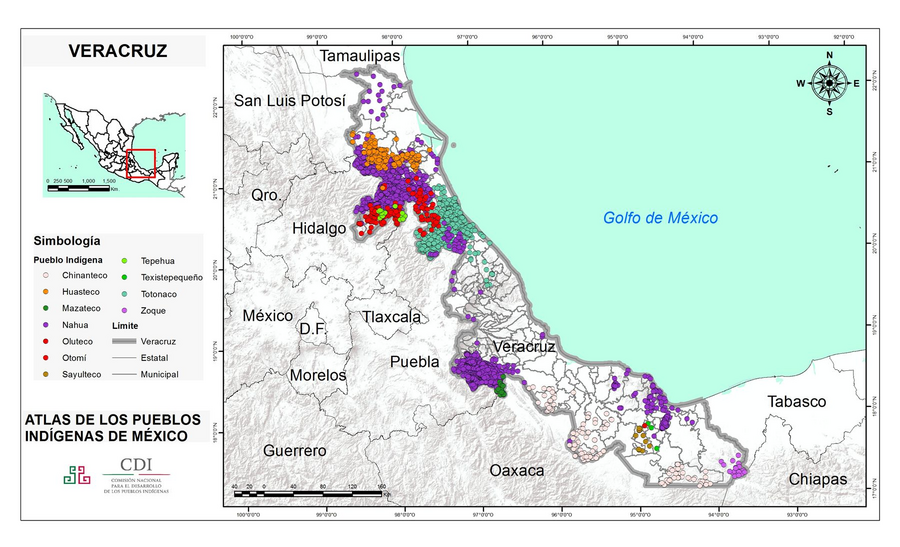
Dispossesions in the Americas

Dispossesions in the Americas

  • Home
  • Explore
  • About
  • Authors
  • Art
  • Bodies
  • Curricula
  • Cultural Heritage
  • Maps
  • Territories
Back to Explore
Map 2015

VERACRUZ

  • INSTITUTO NACIONAL DE LOS PUEBLOS INDIGENAS

  • Download Image

Peoples

  • CHINANTECO
  • HUASTECO
  • MAZATECO
  • NAHUA
  • OLUTECO
  • OTOMI
  • SAYULTECO
  • TEPEHUA
  • TEXISTEPEQUENO
  • TOTONACO
  • ZOQUE

Citation

Instituto Nacional de los Pueblos Indígenas. "Distribución por Entidad Federativa." Atlas de los pueblos indígenas de México. http://atlas.inpi.gob.mx/distribucion-por-entidad-federativa/.

  • Download Image

Reading in Spanish

Map 2015

VERACRUZ

  • INSTITUTO NACIONAL DE LOS PUEBLOS INDIGENAS

  • Download Image
  • Download Image

Reading in Portuguese

Map 2015

VERACRUZ

  • INSTITUTO NACIONAL DE LOS PUEBLOS INDIGENAS

  • Download Image

Peoples

  • CHINANTECO
  • HUASTECO
  • MAZATECO
  • NAHUA
  • OLUTECO
  • OTOMI
  • SAYULTECO
  • TEPEHUA
  • TEXISTEPEQUENO
  • TOTONACO
  • ZOQUE

Citation

Instituto Nacional de los Pueblos Indígenas. "Distribución por Entidad Federativa." Atlas de los pueblos indígenas de México. http://atlas.inpi.gob.mx/distribucion-por-entidad-federativa/.

  • Download Image

Related Content

INTENDENCIA DE TABASCO

INTENDENCIA DE TABASCO

Map 1800
Carte de la Partie de l'Ocean

Carte de la Partie de l'Ocean

Map 1737
Map of the Inca Empire in western South America

Map of the Inca Empire in western South America

Map 1310 - 1525
MAPA DE TIERRAS DE COMUNIDADES NEGRAS

MAPA DE TIERRAS DE COMUNIDADES NEGRAS

Map 2012
Medina Bank

Medina Bank

Map 1997
Mapa general de la Republica de Guatemala. Publicado por Maximilian v. Sonnenstern por orden del gobierno, 1859. Printed by J. Rau, 33 Broadway, NY. G Kraetzer lith, East New York Long Island, N.Y. "Entered according to act of Congress in the year 1859 by M.v Sonnenster...New York. (insets) Plando de la Ciudad de Guatemala;and 6 releif profiles.

Mapa general de la Republica de Guatemala. Publicado por Maximilian v. Sonnenstern por orden del gobierno, 1859. Printed by J. Rau, 33 Broadway, NY. G Kraetzer lith, East New York Long Island, N.Y. "Entered according to act of Congress in the year 1859 by M.v Sonnenster...New York. (insets) Plando de la Ciudad de Guatemala;and 6 releif profiles.

Map 1800
Andy

Andy

Artwork
Las Misiones en América del Sur

Las Misiones en América del Sur

Map 1609 - 1832

Dispossessions in the Americas

A project by

University of Pennsylvania

Copyright 2024

With support from

Mellon Foundation

Site design & development

Element 84

Art Credits

Instituto Nacional de los Pueblos Indígenas. “Distribución por Entidad Federativa.” Atlas de los pueblos indígenas de México. http://atlas.inpi.gob.mx/distribucion-por-entidad-federativa/.

Site Pages

  • Home
  • Explore
  • About
  • Authors
  • Art
  • Bodies
  • Curricula
  • Cultural Heritage
  • Maps
  • Territories