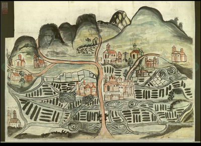
Dispossesions in the Americas

Dispossesions in the Americas

  • Home
  • Explore
  • About
  • Authors
  • Art
  • Bodies
  • Curricula
  • Cultural Heritage
  • Maps
  • Territories
Back to Explore
Map 1560

The Boundaries of Cuauhtinchan and Totomihuacan, Historia Tolteca-Chichimeca, pp. 1-2

  • INDIGENOUS

Published: 1560

  • Download Image

Citation

Gruzinski, Serge. Painting the Conquest: the Mexican Indians and the European Renaissance. Paris: Unesco-Flammarion, 1992. NO ONLINE ACCESS TO SOURCE

  • Download Image

Reading in Spanish

Map 1560

The Boundaries of Cuauhtinchan and Totomihuacan, Historia Tolteca-Chichimeca, pp. 1-2

  • INDIGENOUS

Published: 1560

  • Download Image
  • Download Image

Related Content

PUEBLO MAIJUNA

PUEBLO MAIJUNA

Map 2021
Ruatan or Rattan

Ruatan or Rattan

Map 1775
Carte du Gouvernement de Cayenne ou France Aequinoctiale.

Carte du Gouvernement de Cayenne ou France Aequinoctiale.

Map 1680
Plano general de las montañas orientales del Reino del Peru

Plano general de las montañas orientales del Reino del Peru

Map 1795
PART OF BRAZIL

PART OF BRAZIL

Map 1904
ITINÉRAIRES DE LA MISSION DE BRETTES Dans le Grand Chaco Septentrional (Voyage 1886, 1887-1888)

ITINÉRAIRES DE LA MISSION DE BRETTES Dans le Grand Chaco Septentrional (Voyage 1886, 1887-1888)

Map 1886 - 1888
Mapa de la República de Guatemala

Mapa de la República de Guatemala

Map 1800 - 1900
PUEBLO PIMA

PUEBLO PIMA

Map 2020

Dispossessions in the Americas

A project by

University of Pennsylvania

Copyright 2024

With support from

Mellon Foundation

Site design & development

Element 84

Art Credits

Gruzinski, Serge. Painting the Conquest: the Mexican Indians and the European Renaissance. Paris: Unesco-Flammarion, 1992. NO ONLINE ACCESS TO SOURCE

Site Pages

  • Home
  • Explore
  • About
  • Authors
  • Art
  • Bodies
  • Curricula
  • Cultural Heritage
  • Maps
  • Territories