Dispossesions in the Americas

Dispossesions in the Americas

  • Home
  • Explore
  • About
  • Authors
  • Art
  • Bodies
  • Curricula
  • Cultural Heritage
  • Maps
  • Territories
Back to Explore
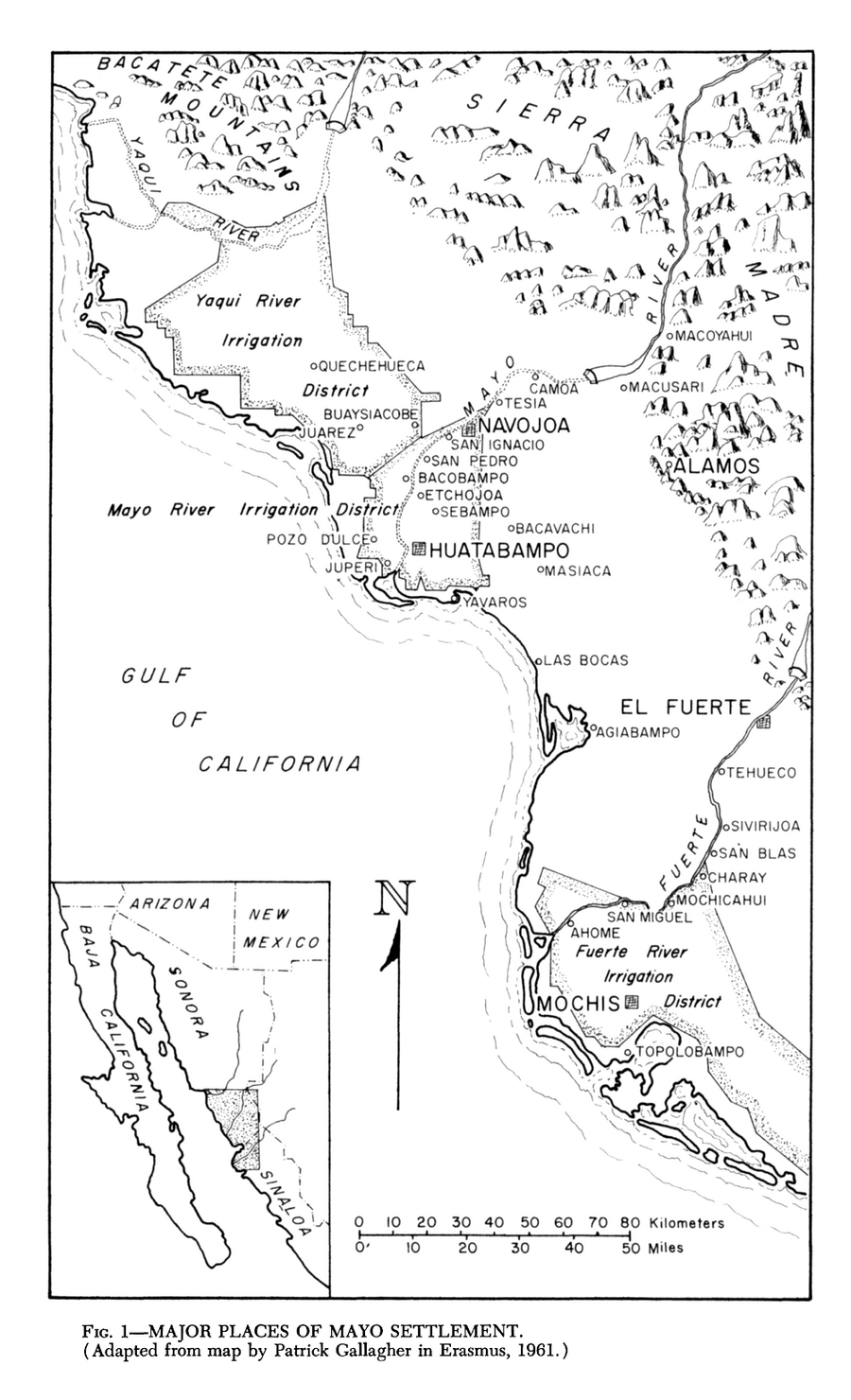
Map 1969

Major Places of Mayo Settlement

  • EDWARD H SPICER

Published: 1969

  • Download Image

Peoples

  • MAYO

Citation

Spicer, Edward H. "The Yaqui and Mayo." In Ethnology, edited by Robert Wauchope and Evon Z. Vogt, 830. Vols. 7-8 of Handbook of Middle American Indians. Austin: University of Texas Press, 1969. https://ebookcentral-proquest-com.proxy.library.upenn.edu/lib/upenn-ebooks/reader.action?docID=4826335&ppg=857.
  • Download Image

Reading in Spanish

Map 1969

Major Places of Mayo Settlement

  • EDWARD H SPICER

Published: 1969

  • Download Image
  • Download Image

Related Content

PARTIE MERIDIONALE DU PEROU

PARTIE MERIDIONALE DU PEROU

Map 1749
Cours de l’Orenoque Depuis ses sources jusqu'à la Mer Avec les Rivieres qui s'y déchargent

Cours de l’Orenoque Depuis ses sources jusqu'à la Mer Avec les Rivieres qui s'y déchargent

Map 1764
South America: From the latest Discoveries, Shewing the Spanish and Portuguese Settlements, according to Mr. D'Anville.

South America: From the latest Discoveries, Shewing the Spanish and Portuguese Settlements, according to Mr. D'Anville.

Map 1771
No Title

No Title

Map 1619
TERRITORIOS ANCESTRALES DE LOS CUATRO PUEBLOS INDIGENAS DE LA SSNM (MAPA APROXIMATIVO DE REFERENCIA)

TERRITORIOS ANCESTRALES DE LOS CUATRO PUEBLOS INDIGENAS DE LA SSNM (MAPA APROXIMATIVO DE REFERENCIA)

Map 2009
Mano and Sutna territory compared with Lehtner's Jornada Mogotton territory

Mano and Sutna territory compared with Lehtner's Jornada Mogotton territory

Map 1997
Mapa intelectual o idea formada de lo que es el Río del Darién o Atrato sacada por Relación de los nat[urales] de aquel Pais: Contiene las bocas principales de d[ic]hos Rios, sus cienegas, caños y riecitos que dan agua a d[ic]ho Pr[incip]al. Año de 1781. A.A.

Mapa intelectual o idea formada de lo que es el Río del Darién o Atrato sacada por Relación de los nat[urales] de aquel Pais: Contiene las bocas principales de d[ic]hos Rios, sus cienegas, caños y riecitos que dan agua a d[ic]ho Pr[incip]al. Año de 1781. A.A.

Map 1781
"Territorio Indígena Cabécar de Ujarrás"

"Territorio Indígena Cabécar de Ujarrás"

Map 2010

Dispossessions in the Americas

A project by

University of Pennsylvania

Copyright 2024

With support from

Mellon Foundation

Site design & development

Element 84

Art Credits

Spicer, Edward H. “The Yaqui and Mayo.” In Ethnology, edited by Robert Wauchope and Evon Z. Vogt, 830. Vols. 7-8 of Handbook of Middle American Indians. Austin: University of Texas Press, 1969. https://ebookcentral-proquest-com.proxy.library.upenn.edu/lib/upenn-ebooks/reader.action?docID=4826335&ppg=857.
Site Pages

  • Home
  • Explore
  • About
  • Authors
  • Art
  • Bodies
  • Curricula
  • Cultural Heritage
  • Maps
  • Territories