Dispossesions in the Americas

Dispossesions in the Americas

  • Home
  • Explore
  • About
  • Authors
  • Art
  • Bodies
  • Curricula
  • Cultural Heritage
  • Maps
  • Territories
Back to Explore
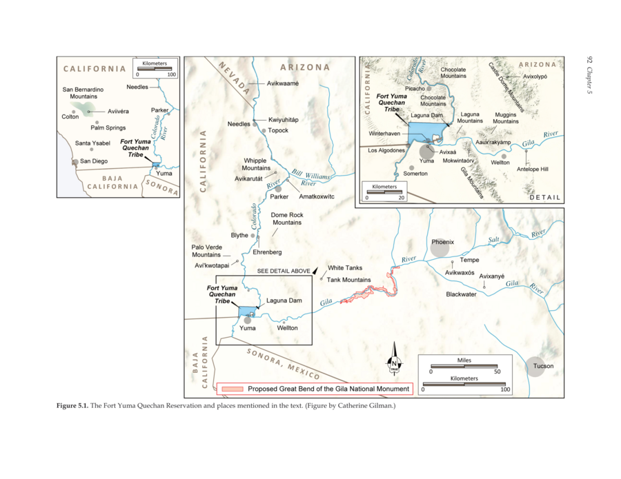
Map 2016

The Fort Yuma Reservation and Places Mentioned in the Text

  • AARON WRIGHT AND MAREN HOPKINS

Published: 2016

  • Download Image

Peoples

  • QUECHAN

Citation

Wright, Aaron M., and Maren P. Hopkins. The Great Bend of the Gila: Contemporary Native American Connections to an Ancestral Landscape. August 2016. Accessed May 25, 2021. https://www.archaeologysouthwest.org/wp-content/uploads/2016/06/gb_ethno.pdf.
  • Download Image

Reading in Spanish

Map 2016

The Fort Yuma Reservation and Places Mentioned in the Text

  • AARON WRIGHT AND MAREN HOPKINS

Published: 2016

  • Download Image
  • Download Image

Related Content

Caminho do Kechuita, Aguapé, RS/Brasil

Caminho do Kechuita, Aguapé, RS/Brasil

Map 1999
Vereinigte Provinzen am LA PLATA Oberperu und Paraguay

Vereinigte Provinzen am LA PLATA Oberperu und Paraguay

Map 1826
N. 100. Carte de la Guyane Française

N. 100. Carte de la Guyane Française

Map 1878
Población o'ob (pima) en 2010

Población o'ob (pima) en 2010

Map 2010
Map of Guatemala: reduced from the survey in the archives of that country.

Map of Guatemala: reduced from the survey in the archives of that country.

Map 1826
TITLED INDIGENOUS TERRITORIES (TIOCs)  IN THE BOLIVIAN INTER-ANDEAN VALLEYS BY 2011

TITLED INDIGENOUS TERRITORIES (TIOCs) IN THE BOLIVIAN INTER-ANDEAN VALLEYS BY 2011

Map 2011
MAPA DE LA PROVINCIA Y MISSIONES DE LA COMPANIA DE IHS DEL NUEVO REYNO DE GRANADA

MAPA DE LA PROVINCIA Y MISSIONES DE LA COMPANIA DE IHS DEL NUEVO REYNO DE GRANADA

Map 1741
Location of three ethno-linguistic groups in the highlands of Guatemala in which joint InHerit-Riecken community-participant mapping took place. Adapted from http://d-maps. com/carte.php?num_car=1717&lang=en)

Location of three ethno-linguistic groups in the highlands of Guatemala in which joint InHerit-Riecken community-participant mapping took place. Adapted from http://d-maps. com/carte.php?num_car=1717&lang=en)

Map 2000

Dispossessions in the Americas

A project by

University of Pennsylvania

Copyright 2024

With support from

Mellon Foundation

Site design & development

Element 84

Art Credits

Wright, Aaron M., and Maren P. Hopkins. The Great Bend of the Gila: Contemporary Native American Connections to an Ancestral Landscape. August 2016. Accessed May 25, 2021. https://www.archaeologysouthwest.org/wp-content/uploads/2016/06/gb_ethno.pdf.
Site Pages

  • Home
  • Explore
  • About
  • Authors
  • Art
  • Bodies
  • Curricula
  • Cultural Heritage
  • Maps
  • Territories