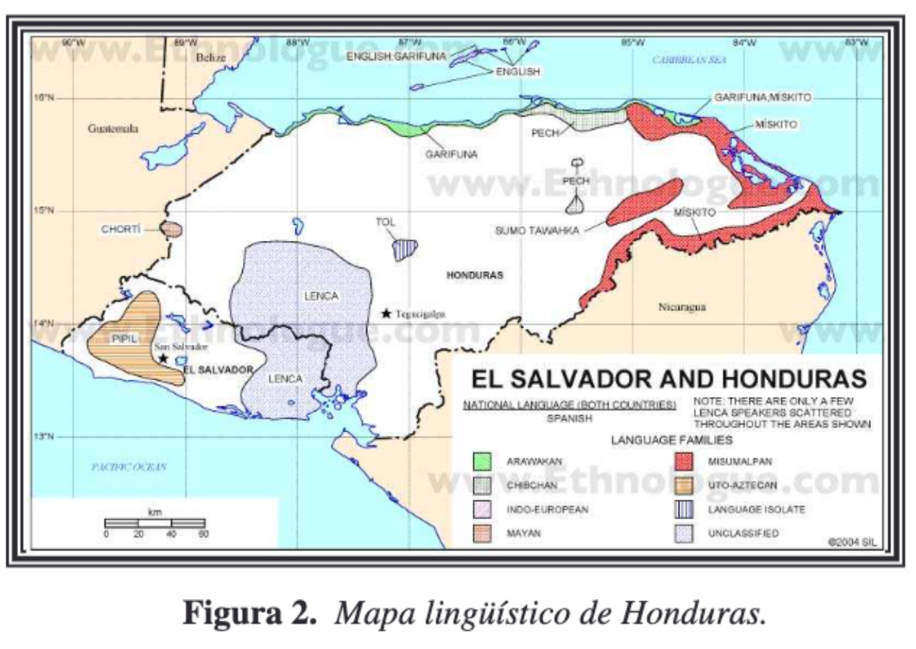
Dispossesions in the Americas

Dispossesions in the Americas

  • Home
  • Explore
  • About
  • Authors
  • Art
  • Bodies
  • Curricula
  • Cultural Heritage
  • Maps
  • Territories
Back to Explore
Map 2004

Mapa linguístico de Honduras

    Published: 2004

    • Download Image

    Peoples

    • CHORTI
    • NAHUAPIPIL
    • LENCA
    • TOL
    • GARIFUNA
    • SUMOTAWAHKA
    • PECH
    • MISKITO

    Citation

    UNESCO. "UNESCO - PROGRAMA HIDROLOGICO INTERNACIONAL (PHI) PARA AMERICA LATINA Y EL CARIBE PROYECTO 'CULTURA DEL AGUA' FICHA PARA EL RELEVAMIENTO DE INFORMACIÓN." N.d. PDF. https://docplayer.es/6931456-Unesco-programa-hidrologico-internacional-phi-para-america-latina-y-el-caribe-proyecto-cultura-del-agua-ficha-para-el-relevamiento-de-informacion.html

    • Download Image

    Reading in Spanish

    Map 2004

    Mapa linguístico de Honduras

      Published: 2004

      • Download Image
      • Download Image

      Reading in Portuguese

      Map 2004

      Mapa linguístico de Honduras

        Published: 2004

        • Download Image

        Peoples

        • CHORTI
        • NAHUAPIPIL
        • LENCA
        • TOL
        • GARIFUNA
        • SUMOTAWAHKA
        • PECH
        • MISKITO

        Citation

        UNESCO. "UNESCO - PROGRAMA HIDROLOGICO INTERNACIONAL (PHI) PARA AMERICA LATINA Y EL CARIBE PROYECTO 'CULTURA DEL AGUA' FICHA PARA EL RELEVAMIENTO DE INFORMACIÓN." N.d. PDF. https://docplayer.es/6931456-Unesco-programa-hidrologico-internacional-phi-para-america-latina-y-el-caribe-proyecto-cultura-del-agua-ficha-para-el-relevamiento-de-informacion.html

        • Download Image

        Related Content

        FACSIMILE: SOUTH AMERICA BY BONNE

        FACSIMILE: SOUTH AMERICA BY BONNE

        Map 1781
        Nuremberg Map of Tenochititlan and the Gulf Coast, 1524

        Nuremberg Map of Tenochititlan and the Gulf Coast, 1524

        Map 1524
        Carte du gouvernement de lisle et terre ferme de Caienne France equinoxial.

        Carte du gouvernement de lisle et terre ferme de Caienne France equinoxial.

        Map 1724
        SCHEMATIC MAP OF DISTRIBUTION OF MAYA-SPEAKING INDIANS (From Morley, 1956, pl.7)

        SCHEMATIC MAP OF DISTRIBUTION OF MAYA-SPEAKING INDIANS (From Morley, 1956, pl.7)

        Map
        N. 24: Guyane.

        N. 24: Guyane.

        Map 1800 - 1899
        Ishir (Chamacoco)

        Ishir (Chamacoco)

        Map 2001
        Mami y Yo y Mi Gallito [Mommy, Me, and My Little Rooster]

        Mami y Yo y Mi Gallito [Mommy, Me, and My Little Rooster]

        Artwork
        A MAP of the Southern Lowlands of BRAZIL

        A MAP of the Southern Lowlands of BRAZIL

        Map 1808 - 1818

        Dispossessions in the Americas

        A project by

        University of Pennsylvania

        Copyright 2024

        With support from

        Mellon Foundation

        Site design & development

        Element 84

        Art Credits

        UNESCO. “UNESCO - PROGRAMA HIDROLOGICO INTERNACIONAL (PHI) PARA AMERICA LATINA Y EL CARIBE PROYECTO ‘CULTURA DEL AGUA’ FICHA PARA EL RELEVAMIENTO DE INFORMACIÓN.” N.d. PDF. https://docplayer.es/6931456-Unesco-programa-hidrologico-internacional-phi-para-america-latina-y-el-caribe-proyecto-cultura-del-agua-ficha-para-el-relevamiento-de-informacion.html

        Site Pages

        • Home
        • Explore
        • About
        • Authors
        • Art
        • Bodies
        • Curricula
        • Cultural Heritage
        • Maps
        • Territories