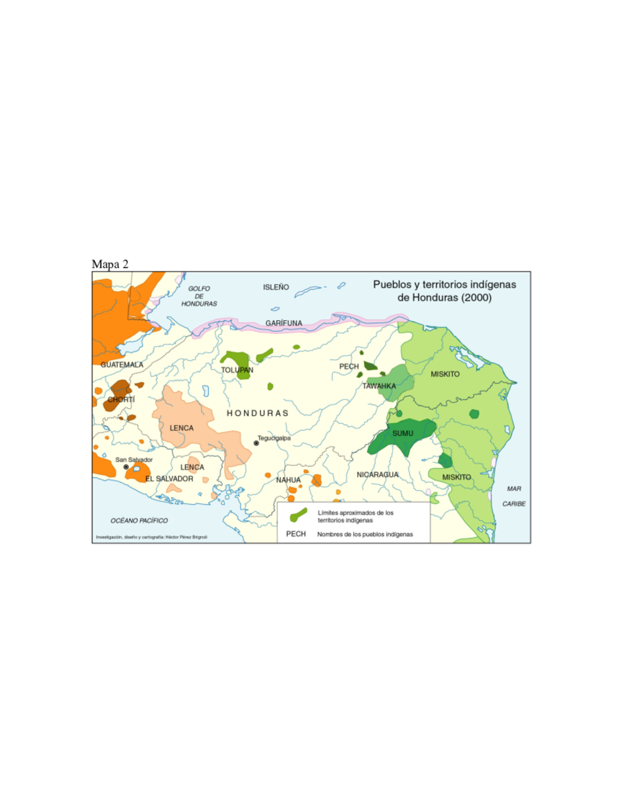
Dispossesions in the Americas

Dispossesions in the Americas

  • Home
  • Explore
  • About
  • Authors
  • Art
  • Bodies
  • Curricula
  • Cultural Heritage
  • Maps
  • Territories
Back to Explore
Map 2000

Pueblos y territorios indígenas de Honduras (2000)

  • HECTOR PEREZ BRIGNOLI

Published: 2005

  • Download Image

Peoples

  • GARIFUNA
  • CHORTI
  • LENCA
  • TOLUPAN
  • NAHUAPIPIL
  • PECH
  • TAWAHKA
  • MAYANGNA
  • MISKITO

Citation

Pérez Brignoli, Héctor. "La dinámica demográfica de las poblaciones indígenas del trópico húmedo en América Central (censos del 2000)." Paper presented at International Union for the Scientific Study of Population XXVth International Population Conference, Tours, France, July 21, 2005. Accessed July 16, 2021. https://iussp2005.princeton.edu/papers/51583.

  • Download Image

Reading in Spanish

Map 2000

Pueblos y territorios indígenas de Honduras (2000)

  • HECTOR PEREZ BRIGNOLI

Published: 2005

  • Download Image
  • Download Image

Reading in Portuguese

Map 2000

Pueblos y territorios indígenas de Honduras (2000)

  • HECTOR PEREZ BRIGNOLI

Published: 2005

  • Download Image

Peoples

  • GARIFUNA
  • CHORTI
  • LENCA
  • TOLUPAN
  • NAHUAPIPIL
  • PECH
  • TAWAHKA
  • MAYANGNA
  • MISKITO

Citation

Pérez Brignoli, Héctor. "La dinámica demográfica de las poblaciones indígenas del trópico húmedo en América Central (censos del 2000)." Paper presented at International Union for the Scientific Study of Population XXVth International Population Conference, Tours, France, July 21, 2005. Accessed July 16, 2021. https://iussp2005.princeton.edu/papers/51583.

  • Download Image

Related Content

Ethnolinguistic territories of the Californias

Ethnolinguistic territories of the Californias

Map 2007
Grupos indígenas de Venezuela

Grupos indígenas de Venezuela

Map 2012
Carta/del/Estado/de Guatemala/en Centro-Americ

Carta/del/Estado/de Guatemala/en Centro-Americ

Map 1832
Mapa de la Republica de Nicaragua leventado por orden del gobierno por Maxmilian v Sonnenstern.

Mapa de la Republica de Nicaragua leventado por orden del gobierno por Maxmilian v Sonnenstern.

Map 1839
Comunidades indígenas del Paraguay

Comunidades indígenas del Paraguay

Map 2001
Côtes du continent d'Amérique despuis le cap Ste Marthe...jusqu'au cap Cameron.

Côtes du continent d'Amérique despuis le cap Ste Marthe...jusqu'au cap Cameron.

Map 1784
CARTE POUR SUIVRE LES VOYAGES du DR. CREVAUX SUR LES RIVIÈRES MAGDALENA;GUAYABERO ET ORÉNOQUE

CARTE POUR SUIVRE LES VOYAGES du DR. CREVAUX SUR LES RIVIÈRES MAGDALENA;GUAYABERO ET ORÉNOQUE

Map 1881
MAPAS DAS PROVINCIAS ETNOGRÁFICAS NO TERRITÓRIO DO RIO GRANDE DO SUL

MAPAS DAS PROVINCIAS ETNOGRÁFICAS NO TERRITÓRIO DO RIO GRANDE DO SUL

Map 1500 - 1600

Dispossessions in the Americas

A project by

University of Pennsylvania

Copyright 2024

With support from

Mellon Foundation

Site design & development

Element 84

Art Credits

Pérez Brignoli, Héctor. “La dinámica demográfica de las poblaciones indígenas del trópico húmedo en América Central (censos del 2000).” Paper presented at International Union for the Scientific Study of Population XXVth International Population Conference, Tours, France, July 21, 2005. Accessed July 16, 2021. https://iussp2005.princeton.edu/papers/51583.

Site Pages

  • Home
  • Explore
  • About
  • Authors
  • Art
  • Bodies
  • Curricula
  • Cultural Heritage
  • Maps
  • Territories