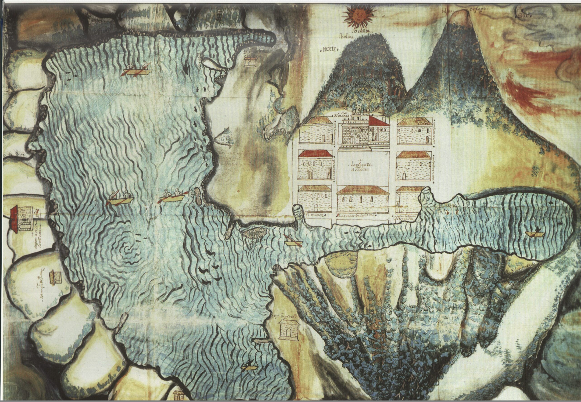
Dispossesions in the Americas

Dispossesions in the Americas

  • Home
  • Explore
  • About
  • Authors
  • Art
  • Bodies
  • Curricula
  • Cultural Heritage
  • Maps
  • Territories
Back to Explore
Map 1585

Asiento del pueblo de Santiago Atitlán c 1585.

    Published: 1585

    • Download Image

    Citation

    "Asiento del pueblo de Santiago Atitlán c 1585." N.Benson Latin American Collection University of Texas at Austin. IN Historical Atlas of Central America by Carolyn Hall and Héctor Pérez Brignoli. John V Cotter, Cartographer. University of Oklhoma Press, 2005.

    • Download Image

    Reading in Spanish

    Map 1585

    Asiento del pueblo de Santiago Atitlán c 1585.

      Published: 1585

      • Download Image
      • Download Image

      Reading in Portuguese

      Map 1585

      Asiento del pueblo de Santiago Atitlán c 1585.

        Published: 1585

        • Download Image

        Citation

        "Asiento del pueblo de Santiago Atitlán c 1585." N.Benson Latin American Collection University of Texas at Austin. IN Historical Atlas of Central America by Carolyn Hall and Héctor Pérez Brignoli. John V Cotter, Cartographer. University of Oklhoma Press, 2005.

        • Download Image

        Related Content

        Tribes of the Gran Chaco: Present day locations

        Tribes of the Gran Chaco: Present day locations

        Map 1946
        Serie Fatherland / Padre Patria

        Serie Fatherland / Padre Patria

        Artwork
        Figure 10.1. Map of Ecuador showing the Western Pichincha research region and the site of Palmitopamba.

        Figure 10.1. Map of Ecuador showing the Western Pichincha research region and the site of Palmitopamba.

        Map -700 - 1534
        Carte de la cote orientale Du Brésil entre le 15e et le 23e degré de latitude australe

        Carte de la cote orientale Du Brésil entre le 15e et le 23e degré de latitude australe

        Map 1821
        PUEBLO K'ICHE

        PUEBLO K'ICHE

        Map 2020
        SOUTH AMERICA Sheet I: ECUADOR;GRANADA;VENEZUELA;AND PARTS OF BRAZIL AND GUYANA

        SOUTH AMERICA Sheet I: ECUADOR;GRANADA;VENEZUELA;AND PARTS OF BRAZIL AND GUYANA

        Map 1842
        Untitled

        Untitled

        Artwork
        DISTRIBUTION OF PRINCIPAL NATIONS AFTER 1300 AD

        DISTRIBUTION OF PRINCIPAL NATIONS AFTER 1300 AD

        Map 1300

        Dispossessions in the Americas

        A project by

        University of Pennsylvania

        Copyright 2024

        With support from

        Mellon Foundation

        Site design & development

        Element 84

        Art Credits

        “Asiento del pueblo de Santiago Atitlán c 1585.” N.Benson Latin American Collection University of Texas at Austin. IN Historical Atlas of Central America by Carolyn Hall and Héctor Pérez Brignoli. John V Cotter, Cartographer. University of Oklhoma Press, 2005.

        Site Pages

        • Home
        • Explore
        • About
        • Authors
        • Art
        • Bodies
        • Curricula
        • Cultural Heritage
        • Maps
        • Territories