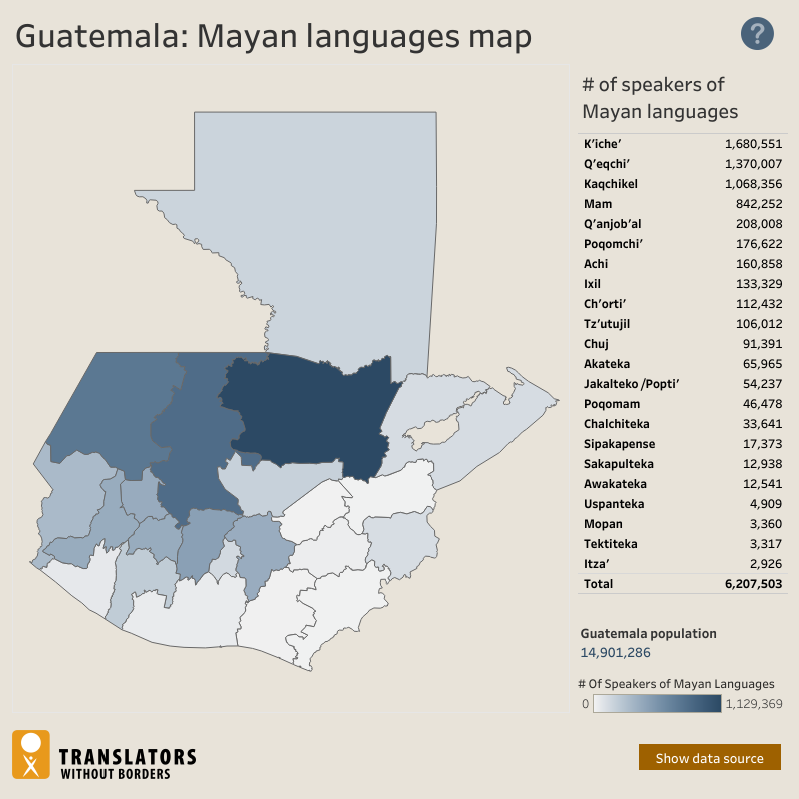
Dispossesions in the Americas

Dispossesions in the Americas

  • Home
  • Explore
  • About
  • Authors
  • Art
  • Bodies
  • Curricula
  • Cultural Heritage
  • Maps
  • Territories
Back to Explore
Map 2018

Guatemala: Mayan languages map

  • TRANSLATORS WITHOUT BORDERS

  • Download Image

Peoples

  • KICHE
  • QEQCHI
  • KAQCHIKEL
  • MAM
  • QANJOBAL
  • POQOMCHI
  • ACHI
  • IXIL
  • CHORTI
  • TZUTUJIL
  • CHUJ
  • AKATEKA
  • JAKALTEKOPOPTI
  • POQOMAM
  • CHALCHITEKA
  • SIPAKAPENSE
  • SAKAPULTEKA
  • AWAKATEKA
  • USPANTEKA
  • MOPAN
  • TEKTITEKA
  • ITZA

Citation

Translators without Borders. "Mayan Languages of Guatemala: Interactive (EN)." Translators Without Borders. Accessed September 30, 2021. https://translatorswithoutborders.org/mayan-languages-of-guatemala-interactive-en/.

  • Download Image

Reading in Spanish

Map 2018

Guatemala: Mayan languages map

  • TRANSLATORS WITHOUT BORDERS

  • Download Image
  • Download Image

Reading in Portuguese

Map 2018

Guatemala: Mayan languages map

  • TRANSLATORS WITHOUT BORDERS

  • Download Image

Peoples

  • KICHE
  • QEQCHI
  • KAQCHIKEL
  • MAM
  • QANJOBAL
  • POQOMCHI
  • ACHI
  • IXIL
  • CHORTI
  • TZUTUJIL
  • CHUJ
  • AKATEKA
  • JAKALTEKOPOPTI
  • POQOMAM
  • CHALCHITEKA
  • SIPAKAPENSE
  • SAKAPULTEKA
  • AWAKATEKA
  • USPANTEKA
  • MOPAN
  • TEKTITEKA
  • ITZA

Citation

Translators without Borders. "Mayan Languages of Guatemala: Interactive (EN)." Translators Without Borders. Accessed September 30, 2021. https://translatorswithoutborders.org/mayan-languages-of-guatemala-interactive-en/.

  • Download Image

Related Content

PUEBLO NANTI

PUEBLO NANTI

Map 2021
AYOREO

AYOREO

Map 2015
LA PROVINCIA DE POTOSÍ EN EL ALTO PERÚ EN EL SIGLO XVII

LA PROVINCIA DE POTOSÍ EN EL ALTO PERÚ EN EL SIGLO XVII

Map 1600 - 1699
Guyana

Guyana

Map 1800 - 1899
A New Map of Part /of the Great River / De la Plata, /of Tucuman / and the adjacent Countries, from Buenos Ayres to Potosí

A New Map of Part /of the Great River / De la Plata, /of Tucuman / and the adjacent Countries, from Buenos Ayres to Potosí

Map 1716
Guiana Shewing the Localities of the Principal Indian Nations

Guiana Shewing the Localities of the Principal Indian Nations

Map 1800 - 1899
"Transversalidad Histórica entre las Tierras Indidas de 1940 y los Pueblos Indígenas de Costa Rica en la actualidad"

"Transversalidad Histórica entre las Tierras Indidas de 1940 y los Pueblos Indígenas de Costa Rica en la actualidad"

Map 1940 - 2014
Navegacion de Buques para el Darien. Mapa topográfico de una porción del Itsmo del Darién mostrando el sitio de la Navegación Pase Oceanico que se propone

Navegacion de Buques para el Darien. Mapa topográfico de una porción del Itsmo del Darién mostrando el sitio de la Navegación Pase Oceanico que se propone

Map 1852

Dispossessions in the Americas

A project by

University of Pennsylvania

Copyright 2024

With support from

Mellon Foundation

Site design & development

Element 84

Art Credits

Translators without Borders. “Mayan Languages of Guatemala: Interactive (EN).” Translators Without Borders. Accessed September 30, 2021. https://translatorswithoutborders.org/mayan-languages-of-guatemala-interactive-en/.

Site Pages

  • Home
  • Explore
  • About
  • Authors
  • Art
  • Bodies
  • Curricula
  • Cultural Heritage
  • Maps
  • Territories