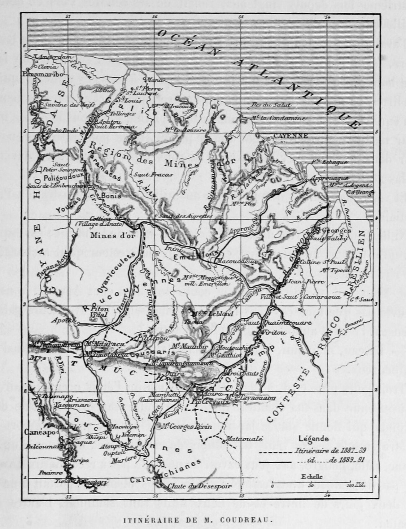
Dispossesions in the Americas

Dispossesions in the Americas

  • Home
  • Explore
  • About
  • Authors
  • Art
  • Bodies
  • Curricula
  • Cultural Heritage
  • Maps
  • Territories
Back to Explore
Map 1893

Itinéraire de M. Coudreau

  • COUDREAU, HENRI

Published: 1893

  • Download Image

Peoples

  • CAICONCHIANES
  • COUSSARIS
  • EMERILLONS
  • GALIBIS
  • OYAMPI
  • PARAMACAS
  • POLIGOUDOUX
  • ROUCOUYENNES
  • YOUCAS

Citation

Chez nos Indiens : quatre années dans la Guyane française (1887-1891)... / Henri Coudreau ;(préface de M. E.-T. Hamy). Gallica. Last modified: September 28, 2015. Accessed, August 29, 2023. https://gallica.bnf.fr/ark:/12148/btv1b53103447t

  • Download Image

Reading in Spanish

Map 1893

Itinéraire de M. Coudreau

  • COUDREAU, HENRI

Published: 1893

  • Download Image
  • Download Image

Reading in Portuguese

Map 1893

Itinéraire de M. Coudreau

  • COUDREAU, HENRI

Published: 1893

  • Download Image

Peoples

  • CAICONCHIANES
  • COUSSARIS
  • EMERILLONS
  • GALIBIS
  • OYAMPI
  • PARAMACAS
  • POLIGOUDOUX
  • ROUCOUYENNES
  • YOUCAS

Citation

Chez nos Indiens : quatre années dans la Guyane française (1887-1891)... / Henri Coudreau ;(préface de M. E.-T. Hamy). Gallica. Last modified: September 28, 2015. Accessed, August 29, 2023. https://gallica.bnf.fr/ark:/12148/btv1b53103447t

  • Download Image

Related Content

CARTE DE LA TERRE FERME de la GUYANE et du Paus des Amazones

CARTE DE LA TERRE FERME de la GUYANE et du Paus des Amazones

Map 1785
Brazil.

Brazil.

Map 1838
PUEBLO SAYULTECO

PUEBLO SAYULTECO

Map 2020
Carta inédita de la extremidad austral de América construída por el P. José Cardiel, S. J. en 1747

Carta inédita de la extremidad austral de América construída por el P. José Cardiel, S. J. en 1747

Map 1700 - 1750
Mapa De La Gobernación Del Paraguay Y Buenos Aires, Con La Línea  Divisoria De Las Tierras De España Y Portugal_1752.

Mapa De La Gobernación Del Paraguay Y Buenos Aires, Con La Línea Divisoria De Las Tierras De España Y Portugal_1752.

Map 1752
Caerte van de rivier Demerary van ouds Immenary gelegen op Suyd Americaes noordkust op de noorder breedte van 6 gr: 40 min: 1759

Caerte van de rivier Demerary van ouds Immenary gelegen op Suyd Americaes noordkust op de noorder breedte van 6 gr: 40 min: 1759

Map 1759
An exact draught of the Gulf of Darien & the coast to Porto Bello with Panama in the South sea & the Scotch settlement in Calledonia

An exact draught of the Gulf of Darien & the coast to Porto Bello with Panama in the South sea & the Scotch settlement in Calledonia

Map 1700 - 1799
Current Ethno-Linguistic Groups of South America

Current Ethno-Linguistic Groups of South America

Map 1990

Dispossessions in the Americas

A project by

University of Pennsylvania

Copyright 2024

With support from

Mellon Foundation

Site design & development

Element 84

Art Credits

Chez nos Indiens : quatre années dans la Guyane française (1887-1891)… / Henri Coudreau ;(préface de M. E.-T. Hamy). Gallica. Last modified: September 28, 2015. Accessed, August 29, 2023. https://gallica.bnf.fr/ark:/12148/btv1b53103447t

Site Pages

  • Home
  • Explore
  • About
  • Authors
  • Art
  • Bodies
  • Curricula
  • Cultural Heritage
  • Maps
  • Territories