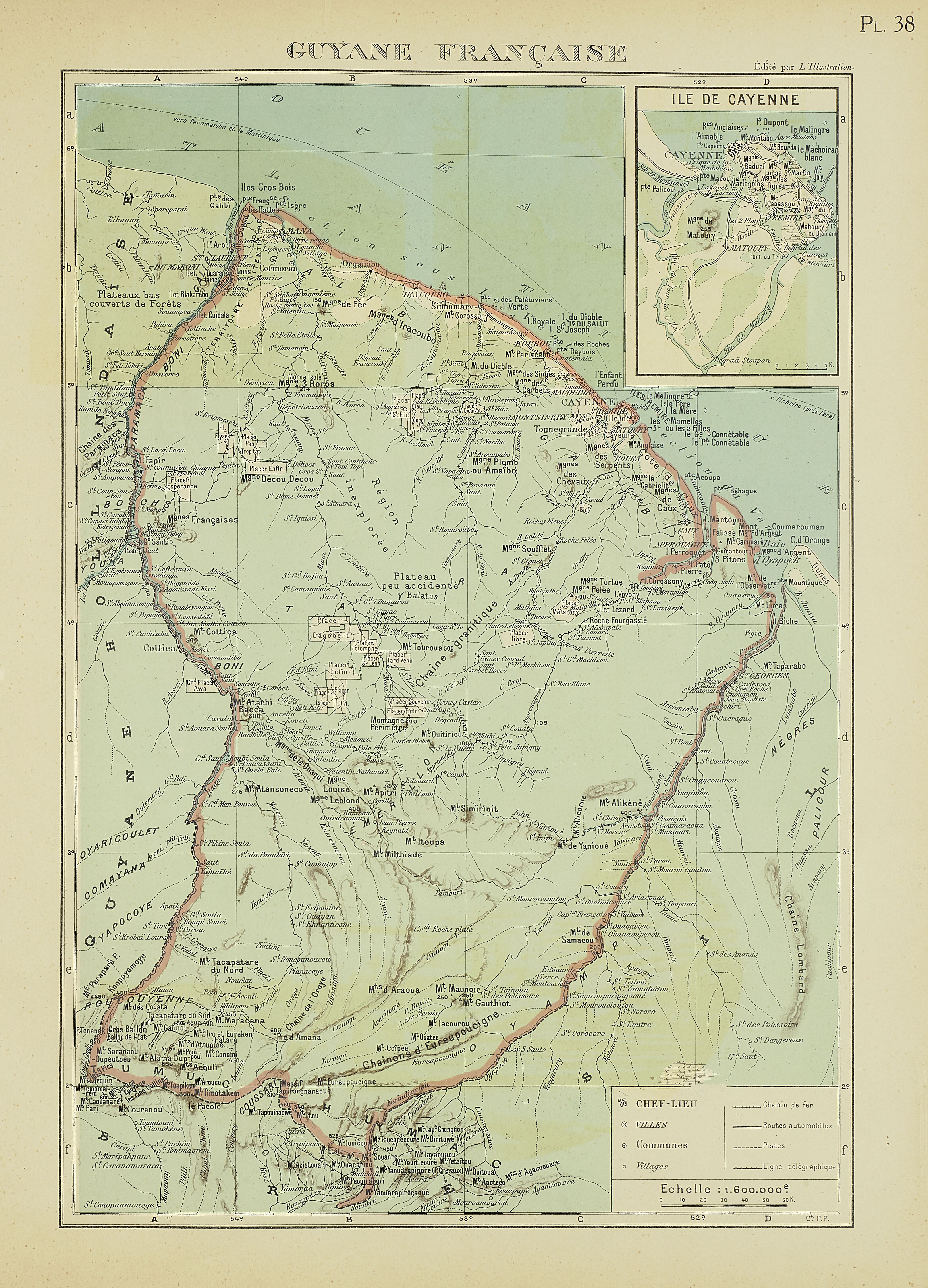
Dispossesions in the Americas

Dispossesions in the Americas

  • Home
  • Explore
  • About
  • Authors
  • Art
  • Bodies
  • Curricula
  • Cultural Heritage
  • Maps
  • Territories
Back to Explore
Map 1929

PL 38: Guyane française.

  • POLLACCHI, PAUL

Published: 1929

  • Download Image

Peoples

  • BOSCHS
  • COMAYANA
  • COUSSARI
  • EMERILLON
  • GALIBI
  • OYAMPIS
  • OYARICOULET
  • PALICOUR
  • ROUCOUYENNE
  • TAYRA
  • YAPOCOYE

Citation

Atlas colonial français : colonies, protectorats et pays sous mandat. Cartes et texte du Commandant P. Pollacchi. Gallica. Last modified: October 28, 2020. Accessed, August 1, 2023. https://gallica.bnf.fr/ark:/12148/bpt6k1100182m/f253.item

  • Download Image

Reading in Spanish

Map 1929

PL 38: Guyane française.

  • POLLACCHI, PAUL

Published: 1929

  • Download Image
  • Download Image

Reading in Portuguese

Map 1929

PL 38: Guyane française.

  • POLLACCHI, PAUL

Published: 1929

  • Download Image

Peoples

  • BOSCHS
  • COMAYANA
  • COUSSARI
  • EMERILLON
  • GALIBI
  • OYAMPIS
  • OYARICOULET
  • PALICOUR
  • ROUCOUYENNE
  • TAYRA
  • YAPOCOYE

Citation

Atlas colonial français : colonies, protectorats et pays sous mandat. Cartes et texte du Commandant P. Pollacchi. Gallica. Last modified: October 28, 2020. Accessed, August 1, 2023. https://gallica.bnf.fr/ark:/12148/bpt6k1100182m/f253.item

  • Download Image

Related Content

Geographical Distribution of the Cuicatec

Geographical Distribution of the Cuicatec

Map 1969
Paraguay;ó prov. de Rio de la Plata cum regionibus adiacentibus Tucuman et Sta. Cruz de la Sierra

Paraguay;ó prov. de Rio de la Plata cum regionibus adiacentibus Tucuman et Sta. Cruz de la Sierra

Map 1600 - 1699
Manuscript Map of the Dagua River Region

Manuscript Map of the Dagua River Region

Map 1764
QUERÉTARO

QUERÉTARO

Map 2015
PEI desvío de un río [PEI Diversion of a River]

PEI desvío de un río [PEI Diversion of a River]

Artwork
Territorio Rama y Kriol: Mapa de Zonas Territoriales. Three Zones proposed by the PADA to ensure a sustainable future for the communities of Rama and Kriol

Territorio Rama y Kriol: Mapa de Zonas Territoriales. Three Zones proposed by the PADA to ensure a sustainable future for the communities of Rama and Kriol

Map 2000
GUANAJUATO

GUANAJUATO

Map 2015
Sin título (Amante perfecto) [Untitled (The Perfect Lover)]

Sin título (Amante perfecto) [Untitled (The Perfect Lover)]

Artwork

Dispossessions in the Americas

A project by

University of Pennsylvania

Copyright 2024

With support from

Mellon Foundation

Site design & development

Element 84

Art Credits

Atlas colonial français : colonies, protectorats et pays sous mandat. Cartes et texte du Commandant P. Pollacchi. Gallica. Last modified: October 28, 2020. Accessed, August 1, 2023. https://gallica.bnf.fr/ark:/12148/bpt6k1100182m/f253.item

Site Pages

  • Home
  • Explore
  • About
  • Authors
  • Art
  • Bodies
  • Curricula
  • Cultural Heritage
  • Maps
  • Territories