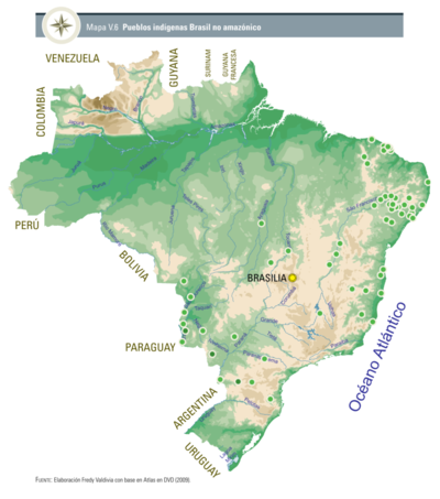
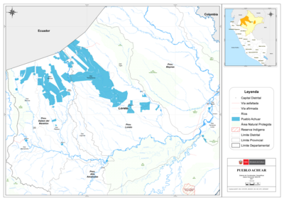
Dispossesions in the Americas

Dispossesions in the Americas

  • Home
  • Explore
  • About
  • Authors
  • Art
  • Bodies
  • Curricula
  • Cultural Heritage
  • Maps
  • Territories
Back to Explore
Map 1766

[Carte de la Guyane depuis le Marony jusqu'au Yary]

  • BUACHE, PHILIPPE (

Published: 1766

  • Download Image

Peoples

  • ACOQUAS
  • AMICOUANES
  • ARMAGOUTOUS
  • AROUAGAIS
  • COUSSANIS
  • COUSSARIS
  • GALIBIS
  • ITOUTANES
  • KARANARIOUX
  • KARICOUCHIANES
  • KOUROUVAOUA
  • MARAONNES
  • MAYES
  • MOREYOUX
  • NOYENNES
  • OROKOYENNES
  • OURANAYOUS
  • OURAMPIS
  • PALENQUES
  • PALICOURS
  • ROUCAOUA
  • TAPIRIS
  • TOCOYENNES

Citation

[Carte de la Guyane depuis le Marony jusqu'au Yary] 60 Minutes [=Om. 105 ;1 : 1 060 000 env] / par Ph. Buache. Terminée ce 29 mars 1766. Gallica. Last modified: November 6, 2012. Accessed, July 17, 2023. https://gallica.bnf.fr/ark:/12148/btv1b8493520z

  • Download Image

Reading in Spanish

Map 1766

[Carte de la Guyane depuis le Marony jusqu'au Yary]

  • BUACHE, PHILIPPE (

Published: 1766

  • Download Image
  • Download Image

Reading in Portuguese

Map 1766

[Carte de la Guyane depuis le Marony jusqu'au Yary]

  • BUACHE, PHILIPPE (

Published: 1766

  • Download Image

Peoples

  • ACOQUAS
  • AMICOUANES
  • ARMAGOUTOUS
  • AROUAGAIS
  • COUSSANIS
  • COUSSARIS
  • GALIBIS
  • ITOUTANES
  • KARANARIOUX
  • KARICOUCHIANES
  • KOUROUVAOUA
  • MARAONNES
  • MAYES
  • MOREYOUX
  • NOYENNES
  • OROKOYENNES
  • OURANAYOUS
  • OURAMPIS
  • PALENQUES
  • PALICOURS
  • ROUCAOUA
  • TAPIRIS
  • TOCOYENNES

Citation

[Carte de la Guyane depuis le Marony jusqu'au Yary] 60 Minutes [=Om. 105 ;1 : 1 060 000 env] / par Ph. Buache. Terminée ce 29 mars 1766. Gallica. Last modified: November 6, 2012. Accessed, July 17, 2023. https://gallica.bnf.fr/ark:/12148/btv1b8493520z

  • Download Image

Related Content

Pueblos indígenas Brasil no amazónico

Pueblos indígenas Brasil no amazónico

Map 2009
Carte anglaise des côtes du Brésil

Carte anglaise des côtes du Brésil

Map 1700 - 1799
Pueblo de Guasca

Pueblo de Guasca

Map 1758
LA PROVINCIA DE POTOSÍ EN EL ALTO PERÚ EN EL SIGLO XVII

LA PROVINCIA DE POTOSÍ EN EL ALTO PERÚ EN EL SIGLO XVII

Map 1600 - 1699
PUEBLO ACHUAR

PUEBLO ACHUAR

Map 2021
Carte des environs de Cap de Nord

Carte des environs de Cap de Nord

Map 1774
Cartografía social – confinamiento por la expansión minera en el sur de La Guajira

Cartografía social – confinamiento por la expansión minera en el sur de La Guajira

Map
Bolivia Or Upper Peru;Chili and the United Provinces Of South America, or La Plata

Bolivia Or Upper Peru;Chili and the United Provinces Of South America, or La Plata

Map 1800 - 1850

Dispossessions in the Americas

A project by

University of Pennsylvania

Copyright 2024

With support from

Mellon Foundation

Site design & development

Element 84

Art Credits

[Carte de la Guyane depuis le Marony jusqu’au Yary] 60 Minutes [=Om. 105 ;1 : 1 060 000 env] / par Ph. Buache. Terminée ce 29 mars 1766. Gallica. Last modified: November 6, 2012. Accessed, July 17, 2023. https://gallica.bnf.fr/ark:/12148/btv1b8493520z

Site Pages

  • Home
  • Explore
  • About
  • Authors
  • Art
  • Bodies
  • Curricula
  • Cultural Heritage
  • Maps
  • Territories