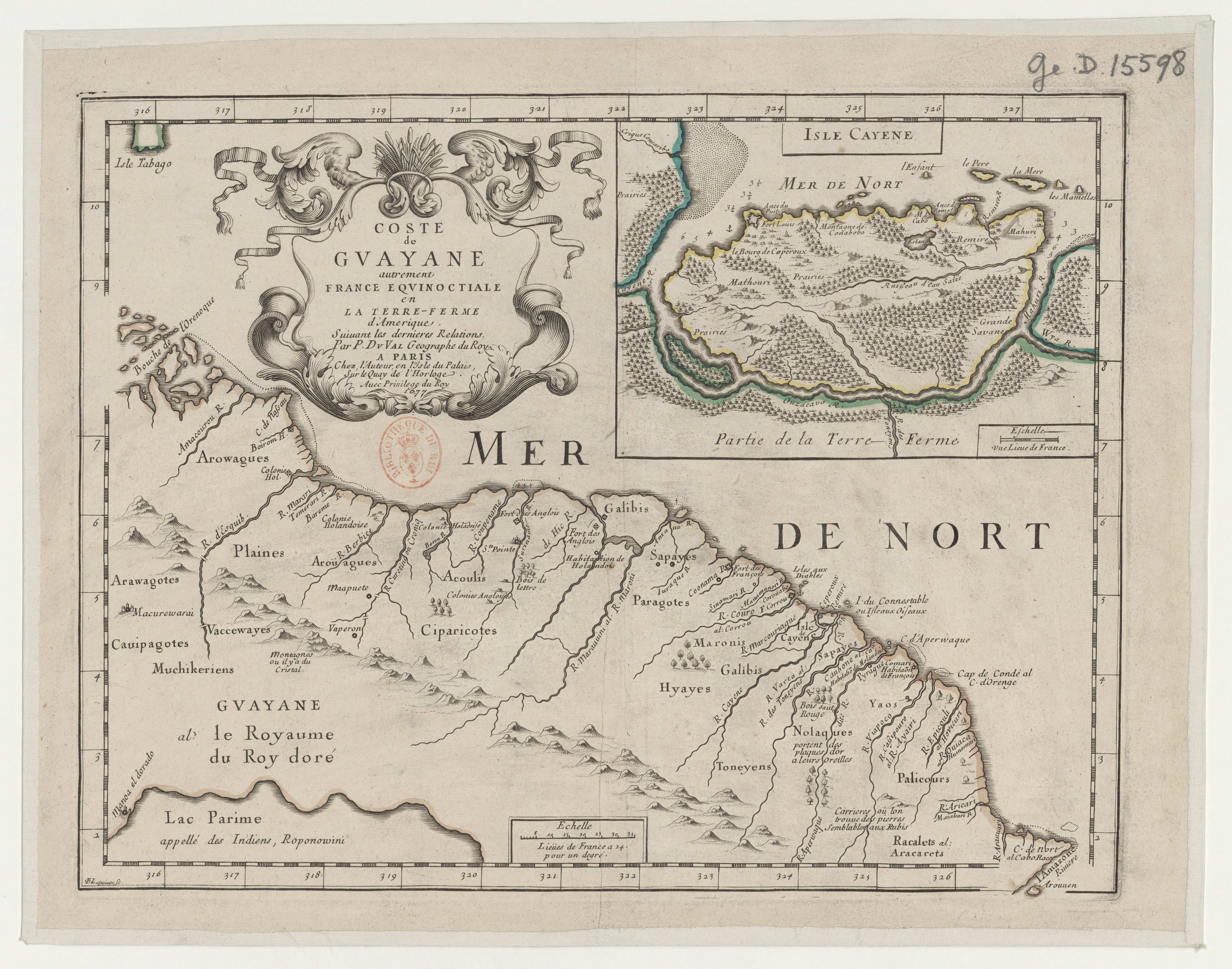
Dispossesions in the Americas

Dispossesions in the Americas

  • Home
  • Explore
  • About
  • Authors
  • Art
  • Bodies
  • Curricula
  • Cultural Heritage
  • Maps
  • Territories
Back to Explore
Map 1729

Carte de la Guïane françoise ou du gouvernement de Caïenne depuis le Cap de Nord jusqu'àla rivière de Maroni inclusivement.

  • ANVILLE, JEAN-BAPTISTE D'

Published: 1729

  • Download Image

Peoples

  • ACOQUAS
  • ARAMISAS
  • ARAVACAS
  • ARMABOUTOUS
  • AROUAS
  • CARANES
  • COUSSARIS
  • GALIBIS
  • MAIEZ
  • MERCIOUX
  • MERILLONS
  • NOURAGUES
  • PALICOURS
  • PIRIOUS
  • OUAYES
  • OYANPIQUES
  • SUPAYES
  • TOCOIEUNES
  • TOUNOIENNES
  • YAYOS

Citation

Carte de la Guïane françoise ou du gouvernement de Caïenne depuis le Cap de Nord jusqu'àla rivière de Maroni inclusivement / par le Sr d'Anville. Gallica. Last modified: October 12, 2013. Accessed, July 15, 2023. https://gallica.bnf.fr/ark:/12148/btv1b85967714

  • Download Image

Reading in Spanish

Map 1729

Carte de la Guïane françoise ou du gouvernement de Caïenne depuis le Cap de Nord jusqu'àla rivière de Maroni inclusivement.

  • ANVILLE, JEAN-BAPTISTE D'

Published: 1729

  • Download Image
  • Download Image

Related Content

Colombia Prima or South America drawn from the large map in eight sheets by Louis Stanislas D'Arcy Delarochette

Colombia Prima or South America drawn from the large map in eight sheets by Louis Stanislas D'Arcy Delarochette

Map 1811
Provincia Franciscana de Yucatán

Provincia Franciscana de Yucatán

Map 1600 - 1699
Location of Nahuat Area on Gulf Coast Plain

Location of Nahuat Area on Gulf Coast Plain

Map 1969
PLANO DEL HATO DEL TAMBO;ADJUNTO A LA ESCRITURA DE DONACIÓN QUE OTORGA PABLO CHIRIBOGA A FAVOR DE LOS INDÍGENAS DE PAPALLACTA

PLANO DEL HATO DEL TAMBO;ADJUNTO A LA ESCRITURA DE DONACIÓN QUE OTORGA PABLO CHIRIBOGA A FAVOR DE LOS INDÍGENAS DE PAPALLACTA

Map 1903
Map of the Inca Empire in western South America

Map of the Inca Empire in western South America

Map 1310 - 1525
REGIÓN MIXE

REGIÓN MIXE

Map 2000
INDIGENOUS DRAFT LABOR (MITA) FOR MINES OF POTOSI UNDER SPANISH COLONIAL RULE – THE CASE OF THE PAKAXA AYMARA POLITY IN THE LATE 16TH CENTURY

INDIGENOUS DRAFT LABOR (MITA) FOR MINES OF POTOSI UNDER SPANISH COLONIAL RULE – THE CASE OF THE PAKAXA AYMARA POLITY IN THE LATE 16TH CENTURY

Map 1570 - 1650
Paraguay, ó prov. de Rio de la Plata cum regionibus adiacentibus Tucuman et Sta. Cruz de la Sierra

Paraguay, ó prov. de Rio de la Plata cum regionibus adiacentibus Tucuman et Sta. Cruz de la Sierra

Map 1633

Dispossessions in the Americas

A project by

University of Pennsylvania

Copyright 2024

With support from

Mellon Foundation

Site design & development

Element 84

Art Credits

Carte de la Guïane françoise ou du gouvernement de Caïenne depuis le Cap de Nord jusqu’àla rivière de Maroni inclusivement / par le Sr d’Anville. Gallica. Last modified: October 12, 2013. Accessed, July 15, 2023. https://gallica.bnf.fr/ark:/12148/btv1b85967714

Site Pages

  • Home
  • Explore
  • About
  • Authors
  • Art
  • Bodies
  • Curricula
  • Cultural Heritage
  • Maps
  • Territories