Dispossesions in the Americas

Dispossesions in the Americas

  • Home
  • Explore
  • About
  • Authors
  • Art
  • Bodies
  • Curricula
  • Cultural Heritage
  • Maps
  • Territories
Back to Explore
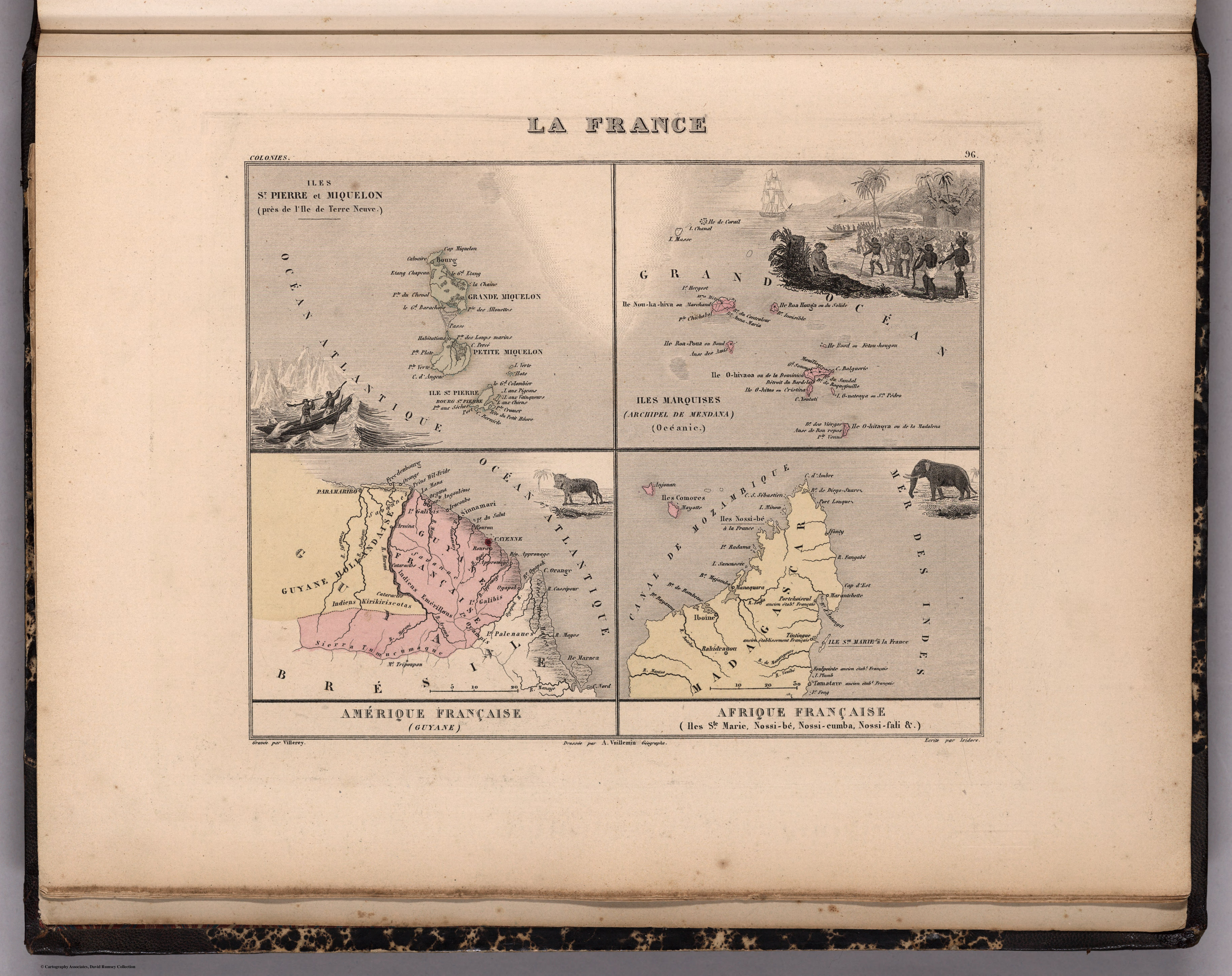
Map 1869

La France. Amérique Française (Guyane). Afrique Française (Illes S.te Marie, Nossi-bé, Nossi-cumba, Nossi-fali &.).

  • MIGEON, J.;VUILLEMIN, A.

Published: 1869

  • Download Image

Peoples

  • EMERILLONS
  • GALIBIS
  • KIRIKIRISCOTAS
  • OYAMPIS
  • PALENAUES

Citation

Iles St. Pierre et Miquelon. Iles Marquises. Guyane. Iles Ste. Marie, Nossi-be, Nossi-cumb... David Rumsey Map Collection. Accessed, July 5, 2023. https://www.davidrumsey.com/luna/servlet/detail/RUMSEY~8~1~269248~90043150:Iles-St--Pierre-et-Miquelon--Iles-M
  • Download Image

Reading in Spanish

Map 1869

La France. Amérique Française (Guyane). Afrique Française (Illes S.te Marie, Nossi-bé, Nossi-cumba, Nossi-fali &.).

  • MIGEON, J.;VUILLEMIN, A.

Published: 1869

  • Download Image
  • Download Image

Related Content

LOCALIZACION GEOGRAFICA DE LAS COMUNIDADES CIMARRONAS EN COLOMBIA DURANTE LOS SIGLOS XVI Y XVII

LOCALIZACION GEOGRAFICA DE LAS COMUNIDADES CIMARRONAS EN COLOMBIA DURANTE LOS SIGLOS XVI Y XVII

Map 1500 - 1699
Cover-up of the Ponce de Leon statue at the Antorcha de la Amistad in Miami, Florida

Cover-up of the Ponce de Leon statue at the Antorcha de la Amistad in Miami, Florida

Artwork
PUEBLO KAKINTE

PUEBLO KAKINTE

Map 2021
FIGURE 26.1. MAP OF COASTAL ECUADOR SHOWING THE PRINCIPAL COASTAL PREHISPANIC CULTURES AND SITES

FIGURE 26.1. MAP OF COASTAL ECUADOR SHOWING THE PRINCIPAL COASTAL PREHISPANIC CULTURES AND SITES

Map 1500
Descripción de la costa de tierra firme que perteneçe a la gouernaçión de Cumaná;que es desde la boca de los Dragos asta el río de Unare para mayor inteligencia de la posición y vecindad que tiene la ysla de la Margarita con dicha costa

Descripción de la costa de tierra firme que perteneçe a la gouernaçión de Cumaná;que es desde la boca de los Dragos asta el río de Unare para mayor inteligencia de la posición y vecindad que tiene la ysla de la Margarita con dicha costa

Map 1661
Area of Tarascan Speech around 1750

Area of Tarascan Speech around 1750

Map 1750
Guide map of the tribes and subjects of Volume 1 of the Handbook

Guide map of the tribes and subjects of Volume 1 of the Handbook

Map
Map of Culhuacan (Valley of Mexico), 1580, Relacion geografica de Culhuacan

Map of Culhuacan (Valley of Mexico), 1580, Relacion geografica de Culhuacan

Map 1580

Dispossessions in the Americas

A project by

University of Pennsylvania

Copyright 2024

With support from

Mellon Foundation

Site design & development

Element 84

Art Credits

Iles St. Pierre et Miquelon. Iles Marquises. Guyane. Iles Ste. Marie, Nossi-be, Nossi-cumb… David Rumsey Map Collection. Accessed, July 5, 2023. https://www.davidrumsey.com/luna/servlet/detail/RUMSEY~8~1~269248~90043150:Iles-St--Pierre-et-Miquelon--Iles-M
Site Pages

  • Home
  • Explore
  • About
  • Authors
  • Art
  • Bodies
  • Curricula
  • Cultural Heritage
  • Maps
  • Territories