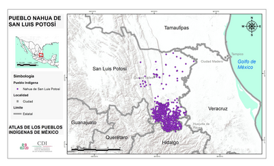
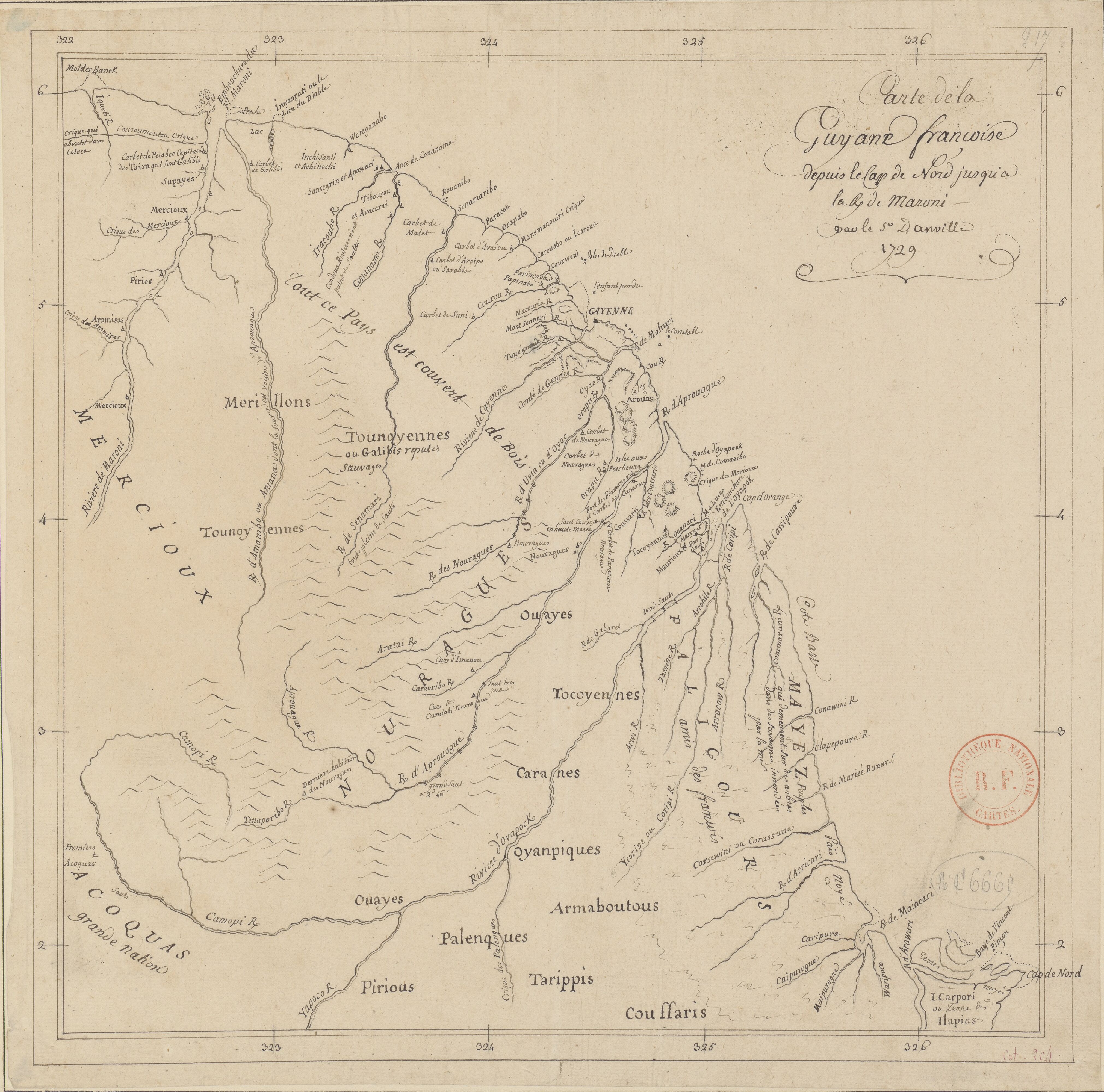
Dispossesions in the Americas

Dispossesions in the Americas

  • Home
  • Explore
  • About
  • Authors
  • Art
  • Bodies
  • Curricula
  • Cultural Heritage
  • Maps
  • Territories
Back to Explore
Map 1729

Carte de la Guyane françoise depuis le cap de Nord jusqu'à la R. de Maroni, par le S.r D anville

  • ANVILLE, JEAN-BAPTISTE D'

Published: 1729

  • Download Image

Peoples

  • ACOQUAS
  • ARMABOUTOUS
  • ARAMISAS
  • AROUAS
  • COUSSARIS
  • GALIBIS
  • MAURIOUX
  • MAYEZ
  • MERCIOUX
  • MERILLONS
  • NOURAGUES
  • OUAYES
  • OYANPIQUES
  • PALENQUES
  • PALICOURS
  • PIRIOUS
  • TARIPPIS
  • TOCOYENNES
  • TOUNOYENNES

Citation

Carte de la Guyane françoise depuis le cap de Nord jusqu'à la r[ivière] de Maroni / par le S[ieu]r D anville. Gallica. Last modified: November 21, 2011. Accessed, June 29, 2023. https://gallica.bnf.fr/ark:/12148/btv1b530092934

  • Download Image

Reading in Spanish

Map 1729

Carte de la Guyane françoise depuis le cap de Nord jusqu'à la R. de Maroni, par le S.r D anville

  • ANVILLE, JEAN-BAPTISTE D'

Published: 1729

  • Download Image
  • Download Image

Reading in Portuguese

Map 1729

Carte de la Guyane françoise depuis le cap de Nord jusqu'à la R. de Maroni, par le S.r D anville

  • ANVILLE, JEAN-BAPTISTE D'

Published: 1729

  • Download Image

Peoples

  • ACOQUAS
  • ARMABOUTOUS
  • ARAMISAS
  • AROUAS
  • COUSSARIS
  • GALIBIS
  • MAURIOUX
  • MAYEZ
  • MERCIOUX
  • MERILLONS
  • NOURAGUES
  • OUAYES
  • OYANPIQUES
  • PALENQUES
  • PALICOURS
  • PIRIOUS
  • TARIPPIS
  • TOCOYENNES
  • TOUNOYENNES

Citation

Carte de la Guyane françoise depuis le cap de Nord jusqu'à la r[ivière] de Maroni / par le S[ieu]r D anville. Gallica. Last modified: November 21, 2011. Accessed, June 29, 2023. https://gallica.bnf.fr/ark:/12148/btv1b530092934

  • Download Image

Related Content

PUEBLO NAHUA DE SAN LUIS POTOSI

PUEBLO NAHUA DE SAN LUIS POTOSI

Map 2020
San Roman and Santa Rosa

San Roman and Santa Rosa

Map 1997
"Territorio Indígena Cabécar de China Kicha"

"Territorio Indígena Cabécar de China Kicha"

Map 2010
INTENDENCIA DE TLAXCALA

INTENDENCIA DE TLAXCALA

Map 1800
REGIÓN TUXTLAS, POPOLUCA-NÁHUATL DE VERACRUZ

REGIÓN TUXTLAS, POPOLUCA-NÁHUATL DE VERACRUZ

Map 2000
"Territorio Indígena Bribrí de Chirripó"

"Territorio Indígena Bribrí de Chirripó"

Map 2010
Plan de l'isle de Pin

Plan de l'isle de Pin

Map 1692
Jalacte

Jalacte

Map 1997

Dispossessions in the Americas

A project by

University of Pennsylvania

Copyright 2024

With support from

Mellon Foundation

Site design & development

Element 84

Art Credits

Carte de la Guyane françoise depuis le cap de Nord jusqu’à la r[ivière] de Maroni / par le S[ieu]r D anville. Gallica. Last modified: November 21, 2011. Accessed, June 29, 2023. https://gallica.bnf.fr/ark:/12148/btv1b530092934

Site Pages

  • Home
  • Explore
  • About
  • Authors
  • Art
  • Bodies
  • Curricula
  • Cultural Heritage
  • Maps
  • Territories