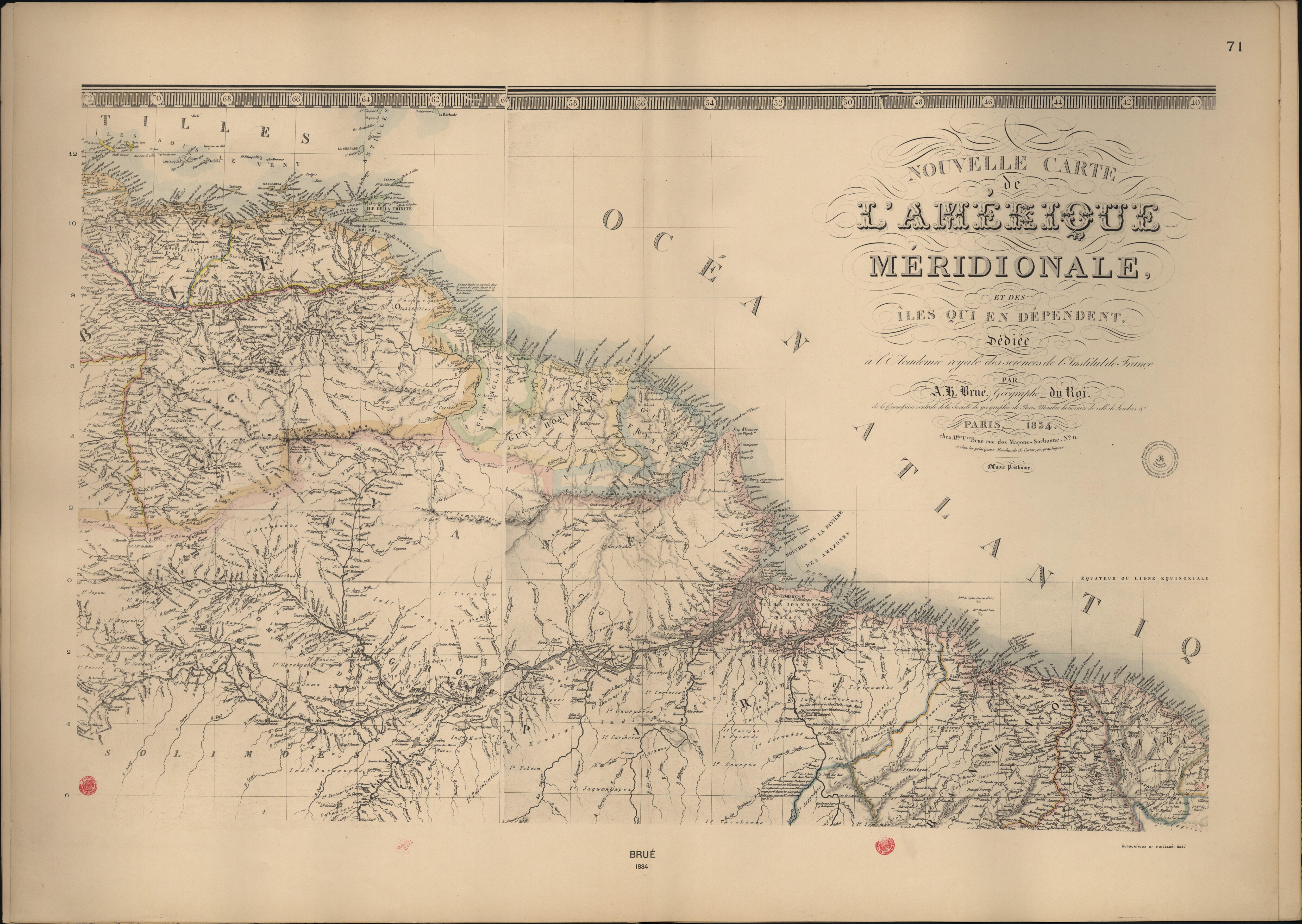
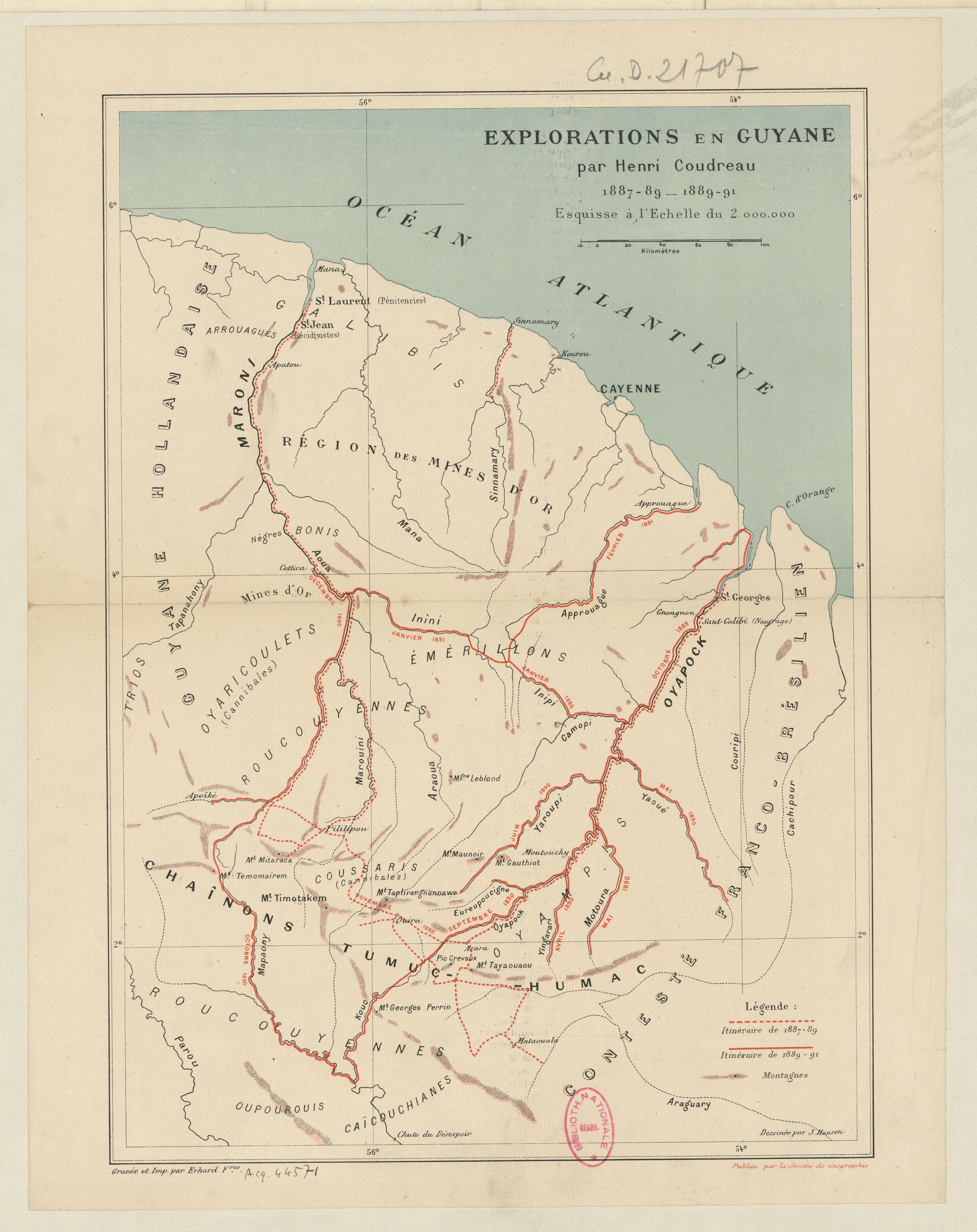
Dispossesions in the Americas

Dispossesions in the Americas

  • Home
  • Explore
  • About
  • Authors
  • Art
  • Bodies
  • Curricula
  • Cultural Heritage
  • Maps
  • Territories
Back to Explore
Map 1887 - 1891

Explorations de la Guyane par Henri Coudreau, 1887-89, 1889-91.

  • COUDREAU, HENRI

Published: 1891

  • Download Image

Peoples

  • ARROUAGUES
  • CAICOUCHIANES
  • COUSSARIS
  • EMERILLONS
  • GALIBIS
  • OUPOUROUIS
  • OYAMPIS
  • OYARICOULETS
  • ROUCOUYENNES

Citation

Explorations de la Guyane / par Henri Coudreau, 1887-89, 1889-91. Gallica. Last modified: November 18, 2013. Accessed, June 29, 2023. https://gallica.bnf.fr/ark:/12148/btv1b530588601

  • Download Image

Reading in Spanish

Map 1887 - 1891

Explorations de la Guyane par Henri Coudreau, 1887-89, 1889-91.

  • COUDREAU, HENRI

Published: 1891

  • Download Image
  • Download Image

Reading in Portuguese

Map 1887 - 1891

Explorations de la Guyane par Henri Coudreau, 1887-89, 1889-91.

  • COUDREAU, HENRI

Published: 1891

  • Download Image

Peoples

  • ARROUAGUES
  • CAICOUCHIANES
  • COUSSARIS
  • EMERILLONS
  • GALIBIS
  • OUPOUROUIS
  • OYAMPIS
  • OYARICOULETS
  • ROUCOUYENNES

Citation

Explorations de la Guyane / par Henri Coudreau, 1887-89, 1889-91. Gallica. Last modified: November 18, 2013. Accessed, June 29, 2023. https://gallica.bnf.fr/ark:/12148/btv1b530588601

  • Download Image

Related Content

"Territorio Indígena Cabécar de Nairi Awari"

"Territorio Indígena Cabécar de Nairi Awari"

Map 2010
Map of Chocho and Ichcatec Areas, Oaxaca0

Map of Chocho and Ichcatec Areas, Oaxaca0

Map 1969
CARTA COROGRÁFICA DE JALISCO, ZACATECAS Y COLIMA

CARTA COROGRÁFICA DE JALISCO, ZACATECAS Y COLIMA

Map 1824
Nouvelle Carte de l'Amérique Méridionale, et des îles qui en dépendent dédiée à l'Academie royale des sciences de l'Institut de France.

Nouvelle Carte de l'Amérique Méridionale, et des îles qui en dépendent dédiée à l'Academie royale des sciences de l'Institut de France.

Map 1800 - 1899
A New Chart of the Coast of Brazil from the Banks of St. Roque, to the Island of St. Sebastian;with the Islands and Soundings in the Offing

A New Chart of the Coast of Brazil from the Banks of St. Roque, to the Island of St. Sebastian;with the Islands and Soundings in the Offing

Map 1794
LINGUISTIC GROUPS OF OAXACA

LINGUISTIC GROUPS OF OAXACA

Map 1966
The Barima River as depicted on Dixon's compass traverse and the AGS million-scale map published in 1940 (bottom)

The Barima River as depicted on Dixon's compass traverse and the AGS million-scale map published in 1940 (bottom)

Map 1895
Bosquejo hodométrico del expacio que media entre los extremos de la Provincia de Suchiltepeques y la Capital de Guatemala, para dar una idea del nuevo camino abierto y costeado por D. José Rossi y Rubí, Alcalde mayor de dicha Provincia, de orden superior, año de 1800.

Bosquejo hodométrico del expacio que media entre los extremos de la Provincia de Suchiltepeques y la Capital de Guatemala, para dar una idea del nuevo camino abierto y costeado por D. José Rossi y Rubí, Alcalde mayor de dicha Provincia, de orden superior, año de 1800.

Map 1800

Dispossessions in the Americas

A project by

University of Pennsylvania

Copyright 2024

With support from

Mellon Foundation

Site design & development

Element 84

Art Credits

Explorations de la Guyane / par Henri Coudreau, 1887-89, 1889-91. Gallica. Last modified: November 18, 2013. Accessed, June 29, 2023. https://gallica.bnf.fr/ark:/12148/btv1b530588601

Site Pages

  • Home
  • Explore
  • About
  • Authors
  • Art
  • Bodies
  • Curricula
  • Cultural Heritage
  • Maps
  • Territories