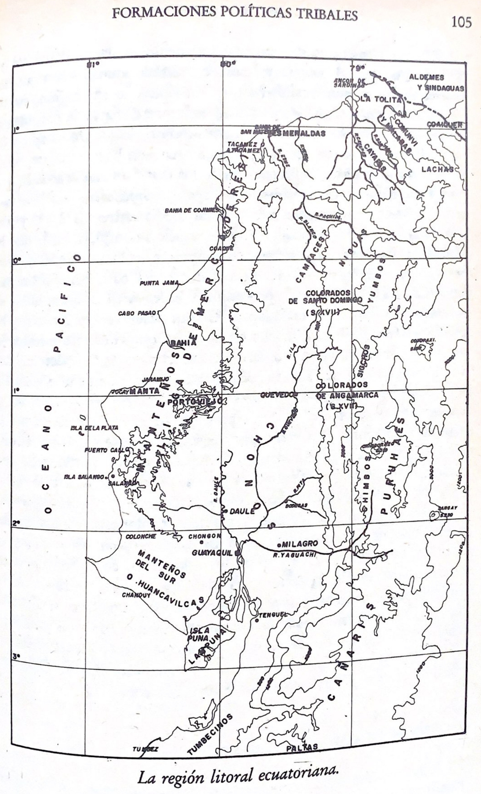
Dispossesions in the Americas

Dispossesions in the Americas

  • Home
  • Explore
  • About
  • Authors
  • Art
  • Bodies
  • Curricula
  • Cultural Heritage
  • Maps
  • Territories
Back to Explore
Map -500 - 1551

La región litoral ecuatoriana

  • ENRIQUE AYALA MORA

Published: 1984

  • Download Image

Peoples

  • MANTA
  • TSACHILA
  • CHONO
  • PURUHA
  • HUANCAVILCAS
  • PUNA
  • YUMBOS
  • CANARIS
  • NIGUAS
  • TUMBECINOS
  • PALTAS

Citation

Ayala Mora;Enrique. Nueva historia del Ecuador. V2. Quito;Ecuador: Corporación Editora Nacional;1983. https://upenn.alma.exlibrisgroup.com/discovery/fulldisplay?vid=01UPENN_INST:Services&id=9918706893503681&inst=01UPENN_INST&context=L

  • Download Image

Reading in Spanish

Map -500 - 1551

La región litoral ecuatoriana

  • ENRIQUE AYALA MORA

Published: 1984

  • Download Image
  • Download Image

Reading in Portuguese

Map -500 - 1551

La región litoral ecuatoriana

  • ENRIQUE AYALA MORA

Published: 1984

  • Download Image

Peoples

  • MANTA
  • TSACHILA
  • CHONO
  • PURUHA
  • HUANCAVILCAS
  • PUNA
  • YUMBOS
  • CANARIS
  • NIGUAS
  • TUMBECINOS
  • PALTAS

Citation

Ayala Mora;Enrique. Nueva historia del Ecuador. V2. Quito;Ecuador: Corporación Editora Nacional;1983. https://upenn.alma.exlibrisgroup.com/discovery/fulldisplay?vid=01UPENN_INST:Services&id=9918706893503681&inst=01UPENN_INST&context=L

  • Download Image

Related Content

Plan de la Rivière de Kourou et de la mission.

Plan de la Rivière de Kourou et de la mission.

Map 1700 - 1799
The Negro Inglés: Most important municipios, 2001

The Negro Inglés: Most important municipios, 2001

Map 2001
Carte générale de Colombie, de la Guyane Française, Hollandaise et Anglaise.

Carte générale de Colombie, de la Guyane Française, Hollandaise et Anglaise.

Map 1800 - 1899
Mapa de la Distribucion de los Idiomas qu se hablan en Guatemala

Mapa de la Distribucion de los Idiomas qu se hablan en Guatemala

Map 1923
Origin of Mayans according to HLA genes and the uniqueness

Origin of Mayans according to HLA genes and the uniqueness

Map
A draught of the Bay of Honduras and part of the Musquetto Shore by George Robertson

A draught of the Bay of Honduras and part of the Musquetto Shore by George Robertson

Map 1766
Fig. 1. Map of French Guiana with locations of the various Amerindian groups

Fig. 1. Map of French Guiana with locations of the various Amerindian groups

Map 1999
PUEBLO TARAHUMARA

PUEBLO TARAHUMARA

Map 2020

Dispossessions in the Americas

A project by

University of Pennsylvania

Copyright 2024

With support from

Mellon Foundation

Site design & development

Element 84

Art Credits

Ayala Mora;Enrique. Nueva historia del Ecuador. V2. Quito;Ecuador: Corporación Editora Nacional;1983. https://upenn.alma.exlibrisgroup.com/discovery/fulldisplay?vid=01UPENN_INST:Services&id=9918706893503681&inst=01UPENN_INST&context=L

Site Pages

  • Home
  • Explore
  • About
  • Authors
  • Art
  • Bodies
  • Curricula
  • Cultural Heritage
  • Maps
  • Territories