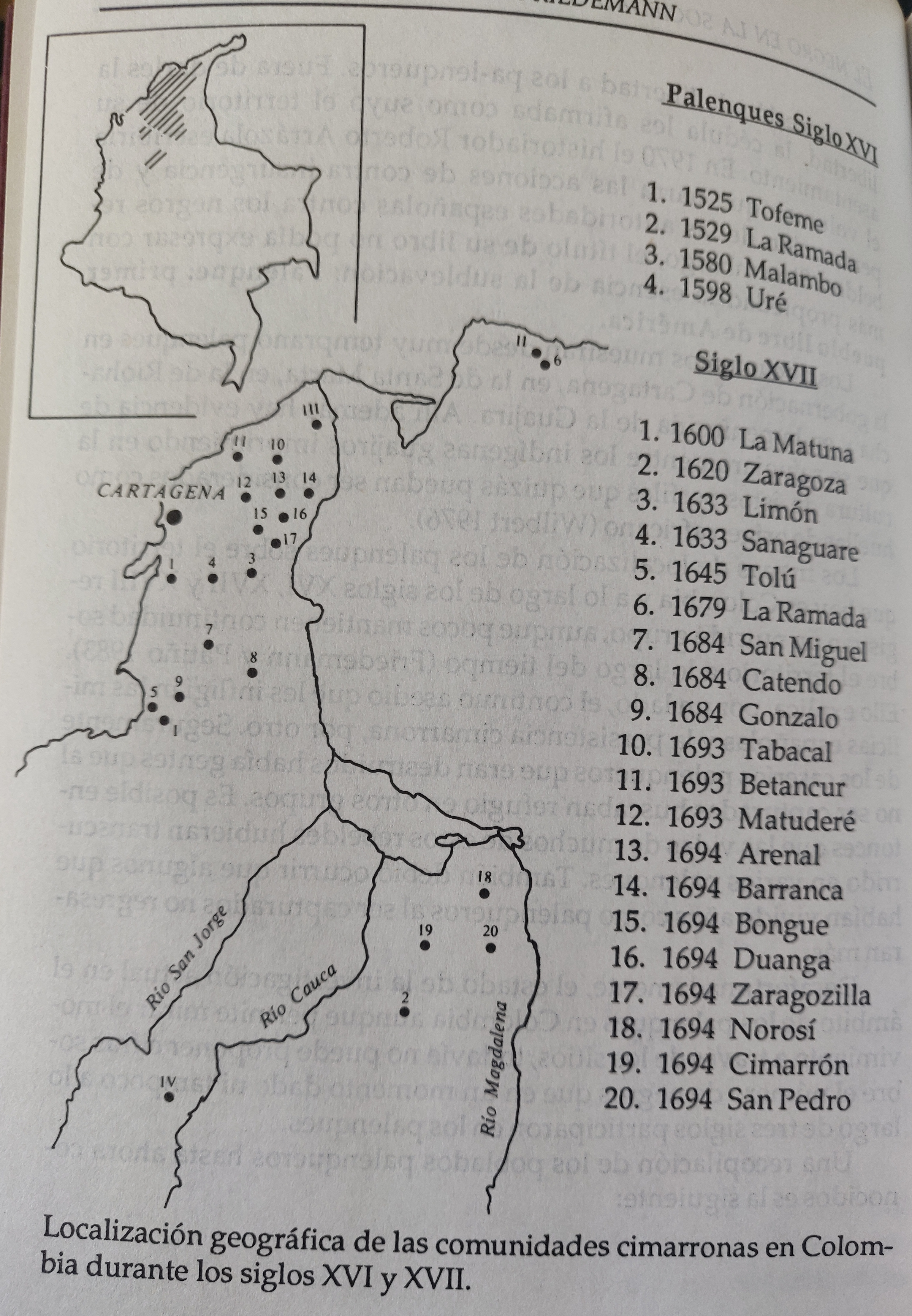
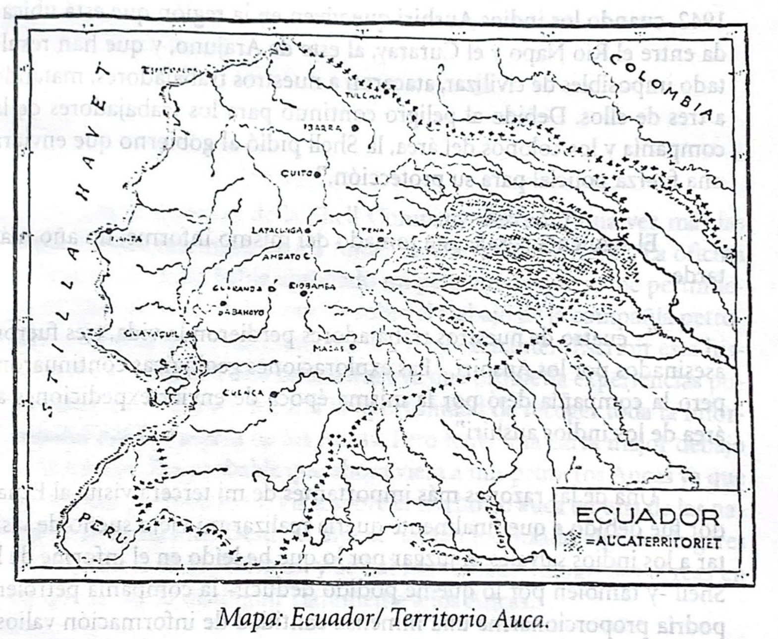
Dispossesions in the Americas

Dispossesions in the Americas

  • Home
  • Explore
  • About
  • Authors
  • Art
  • Bodies
  • Curricula
  • Cultural Heritage
  • Maps
  • Territories
Back to Explore
Map 1940 - 1947

Mapa. Ecuador/Territorio Auca

  • ROLF BLOMBERG

Published: 1997

  • Download Image

Peoples

  • WAORANI

Citation

Blomberg;Rolf. LOS AUCAS DESNUDOS - UNA RESEÑA DE LOS INDIOS DEL ECUADOR / ROLF BLOMBERG;Abya Yala;1997 https://upenn.alma.exlibrisgroup.com/discovery/fulldisplay?vid=01UPENN_INST:Services&id=9978883223203681&inst=01UPENN_INST&context=L

  • Download Image

Reading in Spanish

Map 1940 - 1947

Mapa. Ecuador/Territorio Auca

  • ROLF BLOMBERG

Published: 1997

  • Download Image
  • Download Image

Reading in Portuguese

Map 1940 - 1947

Mapa. Ecuador/Territorio Auca

  • ROLF BLOMBERG

Published: 1997

  • Download Image

Peoples

  • WAORANI

Citation

Blomberg;Rolf. LOS AUCAS DESNUDOS - UNA RESEÑA DE LOS INDIOS DEL ECUADOR / ROLF BLOMBERG;Abya Yala;1997 https://upenn.alma.exlibrisgroup.com/discovery/fulldisplay?vid=01UPENN_INST:Services&id=9978883223203681&inst=01UPENN_INST&context=L

  • Download Image

Related Content

Amerique Meridionale

Amerique Meridionale

Map 1650
Areas of Indian Culture and Principal Tribes in South America

Areas of Indian Culture and Principal Tribes in South America

Map 1500 - 1900
L'Amerique meridionale

L'Amerique meridionale

Map 1650
SOUTH AMERICA

SOUTH AMERICA

Map 1771 - 1806
A Sequel of the Seat of War in the West Indies containing… Sub-map title: A large & accurate MAP of part of the Isthmus of Panama, taken from a Spanish drought exhibiting the Country adjacent to that City and Puerto Bello, with the Roads and Course of the River CHAGRE, by which the Treasure of the South Sea is conveyed a cross the Isthmus

A Sequel of the Seat of War in the West Indies containing… Sub-map title: A large & accurate MAP of part of the Isthmus of Panama, taken from a Spanish drought exhibiting the Country adjacent to that City and Puerto Bello, with the Roads and Course of the River CHAGRE, by which the Treasure of the South Sea is conveyed a cross the Isthmus

Map 1740
El punto de no retorno [The Point of No Return]

El punto de no retorno [The Point of No Return]

Artwork
LOCALIZACION GEOGRAFICA DE LAS COMUNIDADES CIMARRONAS EN COLOMBIA DURANTE LOS SIGLOS XVI Y XVII

LOCALIZACION GEOGRAFICA DE LAS COMUNIDADES CIMARRONAS EN COLOMBIA DURANTE LOS SIGLOS XVI Y XVII

Map 1500 - 1699
La France. AmÊrique Française (Guyane). Afrique Française (Illes S.te Marie, Nossi-bÊ, Nossi-cumba, Nossi-fali &.).

La France. AmÊrique Française (Guyane). Afrique Française (Illes S.te Marie, Nossi-bÊ, Nossi-cumba, Nossi-fali &.).

Map 1869

Dispossessions in the Americas

A project by

University of Pennsylvania

Copyright 2024

With support from

Mellon Foundation

Site design & development

Element 84

Art Credits

Blomberg;Rolf. LOS AUCAS DESNUDOS - UNA RESEÑA DE LOS INDIOS DEL ECUADOR / ROLF BLOMBERG;Abya Yala;1997 https://upenn.alma.exlibrisgroup.com/discovery/fulldisplay?vid=01UPENN_INST:Services&id=9978883223203681&inst=01UPENN_INST&context=L

Site Pages

  • Home
  • Explore
  • About
  • Authors
  • Art
  • Bodies
  • Curricula
  • Cultural Heritage
  • Maps
  • Territories