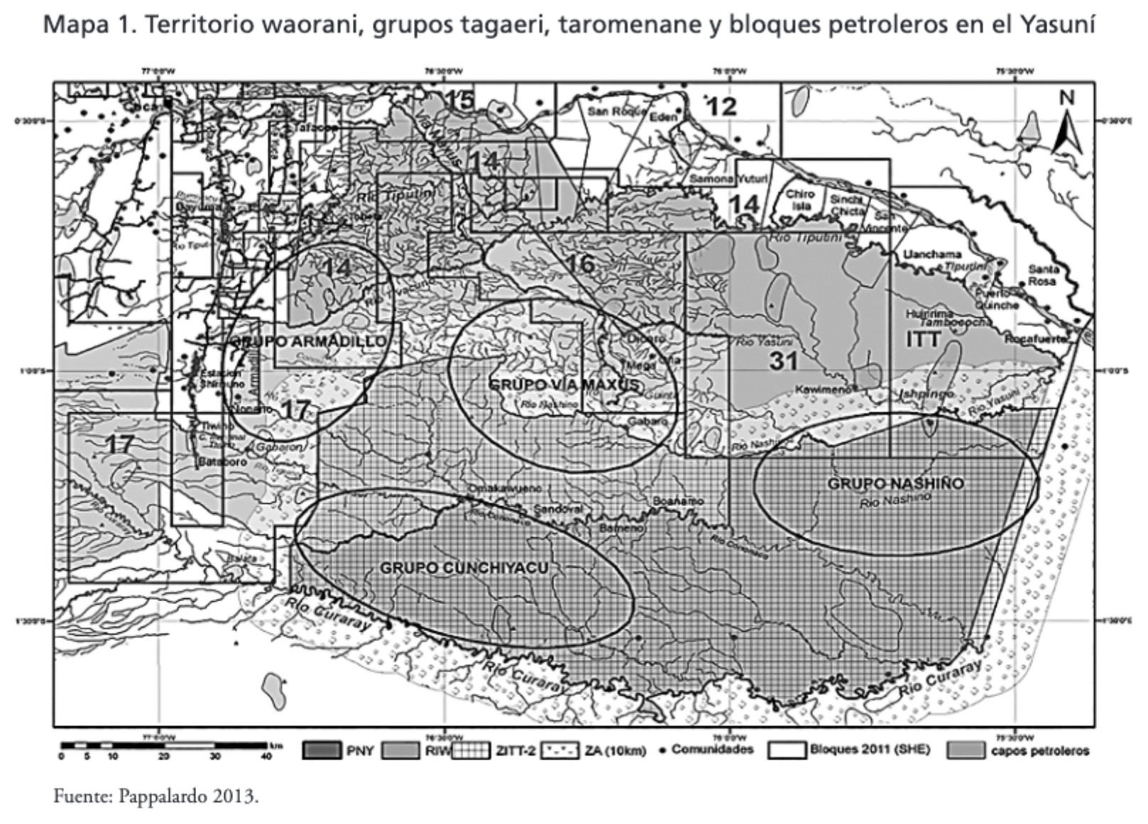
Dispossesions in the Americas

Dispossesions in the Americas

  • Home
  • Explore
  • About
  • Authors
  • Art
  • Bodies
  • Curricula
  • Cultural Heritage
  • Maps
  • Territories
Back to Explore
Map 2013

MAPA 1. TERRITORIO WAORANI;GRUPOS TAGAERI;TAROMENANE Y BLOQUES PETROLEROS EN EL YASUNÍ

  • EUGENIO PAPPALARDO

Published: 2017

  • Download Image

Peoples

  • WAORANI
  • TAGAERI
  • TAROMENANE

Citation

Narváez Quiñónez;Iván Tarcicio. “Amazonía: Cambio de La Comprensión de La Territorialidad Al Interior Del Territorio Waorani (Los Derechos Indígenas)/ Amazon: Change of the Understanding of the Territoriality to the Interior of the Waorani Territory (indigenous Rights).” Eutopía.;no. 12 (2017). https://revistas.flacsoandes.edu.ec/eutopia/article/view/2906/2052

  • Download Image

Reading in Spanish

Map 2013

MAPA 1. TERRITORIO WAORANI;GRUPOS TAGAERI;TAROMENANE Y BLOQUES PETROLEROS EN EL YASUNÍ

  • EUGENIO PAPPALARDO

Published: 2017

  • Download Image
  • Download Image

Reading in Portuguese

Map 2013

MAPA 1. TERRITORIO WAORANI;GRUPOS TAGAERI;TAROMENANE Y BLOQUES PETROLEROS EN EL YASUNÍ

  • EUGENIO PAPPALARDO

Published: 2017

  • Download Image

Peoples

  • WAORANI
  • TAGAERI
  • TAROMENANE

Citation

Narváez Quiñónez;Iván Tarcicio. “Amazonía: Cambio de La Comprensión de La Territorialidad Al Interior Del Territorio Waorani (Los Derechos Indígenas)/ Amazon: Change of the Understanding of the Territoriality to the Interior of the Waorani Territory (indigenous Rights).” Eutopía.;no. 12 (2017). https://revistas.flacsoandes.edu.ec/eutopia/article/view/2906/2052

  • Download Image

Related Content

Preliminary Map;portion of north east [sic] Nicaragua: Brown's Camp to Pis Pis District.

Preliminary Map;portion of north east [sic] Nicaragua: Brown's Camp to Pis Pis District.

Map 1927
Voyage d'exploration du Docteur Crevaux, 9 juillet - 31 novembre 1877 : distribution des sauvages dans les Guyanes.

Voyage d'exploration du Docteur Crevaux, 9 juillet - 31 novembre 1877 : distribution des sauvages dans les Guyanes.

Map 1877
PUEBLO CHONTAL DE TABASCO

PUEBLO CHONTAL DE TABASCO

Map 2020
[Plano de la Isla de Cuba con los derroteros de las naves que vienen de Nueva España al Reino que llaman de Bahama el Nuevo y de las que van a Nueva España y Veracruz]

[Plano de la Isla de Cuba con los derroteros de las naves que vienen de Nueva España al Reino que llaman de Bahama el Nuevo y de las que van a Nueva España y Veracruz]

Map 1500 - 1599
SKETCH MAP OF THE CAPUCHIN MISSIONS IN GUAYANA ABOUT 1779

SKETCH MAP OF THE CAPUCHIN MISSIONS IN GUAYANA ABOUT 1779

Map 1779
MAPA DE COATLINCHAN/ MAP OF COALINCHAN

MAPA DE COATLINCHAN/ MAP OF COALINCHAN

Map 1500 - 1599
Guaraní Occidentales

Guaraní Occidentales

Map 2001
XXIV. Carte du Rio Grande de la Magdalena, depuis ses sources jusqu'a son embouchure.

XXIV. Carte du Rio Grande de la Magdalena, depuis ses sources jusqu'a son embouchure.

Map 1799 - 1804

Dispossessions in the Americas

A project by

University of Pennsylvania

Copyright 2024

With support from

Mellon Foundation

Site design & development

Element 84

Art Credits

Narváez Quiñónez;Iván Tarcicio. “Amazonía: Cambio de La Comprensión de La Territorialidad Al Interior Del Territorio Waorani (Los Derechos Indígenas)/ Amazon: Change of the Understanding of the Territoriality to the Interior of the Waorani Territory (indigenous Rights).” Eutopía.;no. 12 (2017). https://revistas.flacsoandes.edu.ec/eutopia/article/view/2906/2052

Site Pages

  • Home
  • Explore
  • About
  • Authors
  • Art
  • Bodies
  • Curricula
  • Cultural Heritage
  • Maps
  • Territories