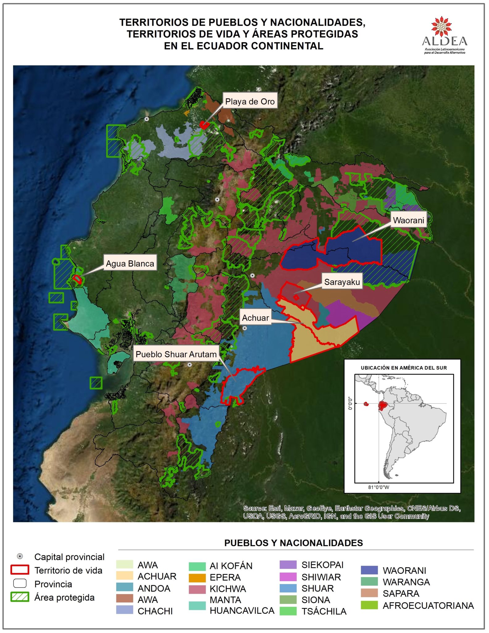
Dispossesions in the Americas

Dispossesions in the Americas

  • Home
  • Explore
  • About
  • Authors
  • Art
  • Bodies
  • Curricula
  • Cultural Heritage
  • Maps
  • Territories
Back to Explore
Map 2016 - 2018

TERRITORIOS DE LOS PUEBLOS Y NACIONALIDADES;TERRITORIOS DE VIDA Y AREAS PROTEGIDAS EN EL ECUADOR CONTINENTAL

  • PAOLA MALDONADO;JAIME ROBLES;VERÓNICA POTES

Published: 2021

  • Download Image

Peoples

  • AWA
  • ACHUAR
  • ANDOA
  • CHACHI
  • COFAN
  • EPERA
  • KICHWA
  • MANTA
  • HUANCAVILCA
  • SECOYA
  • SHIWIAR
  • SHUAR
  • SIONA
  • TSACHILA
  • WAORANI
  • WARANKA
  • SAPARA
  • AFROECUATORIANA

Citation

Maldonado;Paola;Jaime Robles;and Verónica Potes. “Ecuador.” Territorios de Vida;May 30;2021. https://report.territoriesoflife.org/es/analisis-regional-y-nacional/ecuador/.

  • Download Image

Reading in Spanish

Map 2016 - 2018

TERRITORIOS DE LOS PUEBLOS Y NACIONALIDADES;TERRITORIOS DE VIDA Y AREAS PROTEGIDAS EN EL ECUADOR CONTINENTAL

  • PAOLA MALDONADO;JAIME ROBLES;VERÓNICA POTES

Published: 2021

  • Download Image
  • Download Image

Reading in Portuguese

Map 2016 - 2018

TERRITORIOS DE LOS PUEBLOS Y NACIONALIDADES;TERRITORIOS DE VIDA Y AREAS PROTEGIDAS EN EL ECUADOR CONTINENTAL

  • PAOLA MALDONADO;JAIME ROBLES;VERÓNICA POTES

Published: 2021

  • Download Image

Peoples

  • AWA
  • ACHUAR
  • ANDOA
  • CHACHI
  • COFAN
  • EPERA
  • KICHWA
  • MANTA
  • HUANCAVILCA
  • SECOYA
  • SHIWIAR
  • SHUAR
  • SIONA
  • TSACHILA
  • WAORANI
  • WARANKA
  • SAPARA
  • AFROECUATORIANA

Citation

Maldonado;Paola;Jaime Robles;and Verónica Potes. “Ecuador.” Territorios de Vida;May 30;2021. https://report.territoriesoflife.org/es/analisis-regional-y-nacional/ecuador/.

  • Download Image

Related Content

No Title

No Title

Map 1647
PARTE DEL MAR DEL SUR DESDE C. DE S. FRANCISCO HASTA PAIJTA EN LA COSTA DE PERÚ

PARTE DEL MAR DEL SUR DESDE C. DE S. FRANCISCO HASTA PAIJTA EN LA COSTA DE PERÚ

Map 1628
THE QULLASUYU IN THE 1530s – SOUTHERN DISTRICT OF THE INCA STATE

THE QULLASUYU IN THE 1530s – SOUTHERN DISTRICT OF THE INCA STATE

Map 1530
GUANAJUATO

GUANAJUATO

Map 2015
ETATS-UNIS DU BRÉSIL: Carte politique

ETATS-UNIS DU BRÉSIL: Carte politique

Map 1908
Protected Natural Areas in the Maya Region

Protected Natural Areas in the Maya Region

Map 2000 - 2100
Carte anglaise de la côte Nord du Brésil

Carte anglaise de la côte Nord du Brésil

Map 1600 - 1799
Ursa Tuquina, Black Light

Ursa Tuquina, Black Light

Artwork

Dispossessions in the Americas

A project by

University of Pennsylvania

Copyright 2024

With support from

Mellon Foundation

Site design & development

Element 84

Art Credits

Maldonado;Paola;Jaime Robles;and Verónica Potes. “Ecuador.” Territorios de Vida;May 30;2021. https://report.territoriesoflife.org/es/analisis-regional-y-nacional/ecuador/.

Site Pages

  • Home
  • Explore
  • About
  • Authors
  • Art
  • Bodies
  • Curricula
  • Cultural Heritage
  • Maps
  • Territories