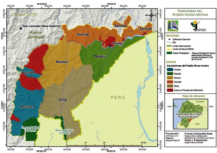
Dispossesions in the Americas

Dispossesions in the Americas

  • Home
  • Explore
  • About
  • Authors
  • Art
  • Bodies
  • Curricula
  • Cultural Heritage
  • Maps
  • Territories
Back to Explore
Map 2017

TERRITORIO DEL PUEBLO SHUAR ATRUAM

  • EQUIPO TIERRAS CGPSHA

Published: 2017

  • Download Image

Peoples

  • SHUAR

Citation

Courtine;E. (2018;September 9). El Pueblo Shuar Arutam de la Cordillera del Condor. ICCA Consortium. Retrieved April 5;2022;from https://www.iccaconsortium.org/index.php/es/2017/03/31/el-pueblo-shuar-arutam-de-la-cordillera-del-condor-2/

  • Download Image

Reading in Spanish

Map 2017

TERRITORIO DEL PUEBLO SHUAR ATRUAM

  • EQUIPO TIERRAS CGPSHA

Published: 2017

  • Download Image
  • Download Image

Reading in Portuguese

Map 2017

TERRITORIO DEL PUEBLO SHUAR ATRUAM

  • EQUIPO TIERRAS CGPSHA

Published: 2017

  • Download Image

Peoples

  • SHUAR

Citation

Courtine;E. (2018;September 9). El Pueblo Shuar Arutam de la Cordillera del Condor. ICCA Consortium. Retrieved April 5;2022;from https://www.iccaconsortium.org/index.php/es/2017/03/31/el-pueblo-shuar-arutam-de-la-cordillera-del-condor-2/

  • Download Image

Related Content

CARTE DU PEROU DU FLEUVE DES AMAZONES ET DU BRESIL

CARTE DU PEROU DU FLEUVE DES AMAZONES ET DU BRESIL

Map 1700 - 1799
CARTA GEOGRÁFICA DEL ECUADOR POR DR. TEODORO WOLF;PUBLICADA POR ORDEN DEL SUPREMO GOBIERNO DE LA REPÚBLICA Y TRABAJADA BAJO LAS PRESIDENCIAS DE LOS EE. SEÑORES DR. D.J.M. PLÁCIDO CAAMAÑO Y DR. D. ANTONIO FLORES. 1892 ... INSTITUTO GEOGRAFICO DE H. WAGNER & E. DEBES EN LEIPZIG. (WITH) LA REGION ORIENTAL DEL ECUADOR. (WITH) ARCHIPIÉLAGO DE GALÁPAGOS.

CARTA GEOGRÁFICA DEL ECUADOR POR DR. TEODORO WOLF;PUBLICADA POR ORDEN DEL SUPREMO GOBIERNO DE LA REPÚBLICA Y TRABAJADA BAJO LAS PRESIDENCIAS DE LOS EE. SEÑORES DR. D.J.M. PLÁCIDO CAAMAÑO Y DR. D. ANTONIO FLORES. 1892 ... INSTITUTO GEOGRAFICO DE H. WAGNER & E. DEBES EN LEIPZIG. (WITH) LA REGION ORIENTAL DEL ECUADOR. (WITH) ARCHIPIÉLAGO DE GALÁPAGOS.

Map 1892
PUEBLO CHOCHOLTECO

PUEBLO CHOCHOLTECO

Map 2020
Carte du Chili depuis le sud du Perou jusqu'au Cap Horn ...
     par Mr. Bonne, Ingr. Hydrographe de la Marine.

Carte du Chili depuis le sud du Perou jusqu'au Cap Horn ... par Mr. Bonne, Ingr. Hydrographe de la Marine.

Map 1780
Carte du Pérou et Brésil sep.l de Tierra-Firme, de Guyana, et de la Rivière des Amazones: Ce qui fait la partie Boréale de l'Amérique Meridio. le. Par le Sr. D' Anville

Carte du Pérou et Brésil sep.l de Tierra-Firme, de Guyana, et de la Rivière des Amazones: Ce qui fait la partie Boréale de l'Amérique Meridio. le. Par le Sr. D' Anville

Map 1700 - 1799
Population Speaking Indigenous Languages in Nicaragua

Population Speaking Indigenous Languages in Nicaragua

Map 2000
PUEBLO NOMATSIGENGA

PUEBLO NOMATSIGENGA

Map 2021
SONORA

SONORA

Map 2015

Dispossessions in the Americas

A project by

University of Pennsylvania

Copyright 2024

With support from

Mellon Foundation

Site design & development

Element 84

Art Credits

Courtine;E. (2018;September 9). El Pueblo Shuar Arutam de la Cordillera del Condor. ICCA Consortium. Retrieved April 5;2022;from https://www.iccaconsortium.org/index.php/es/2017/03/31/el-pueblo-shuar-arutam-de-la-cordillera-del-condor-2/

Site Pages

  • Home
  • Explore
  • About
  • Authors
  • Art
  • Bodies
  • Curricula
  • Cultural Heritage
  • Maps
  • Territories