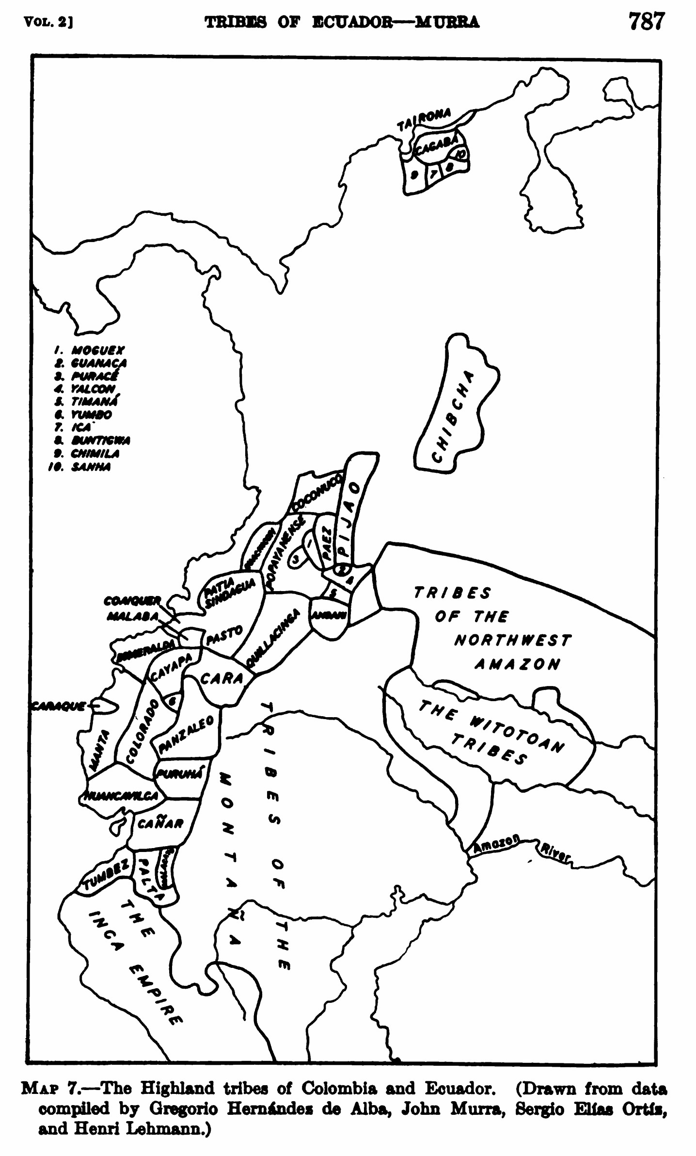
Dispossesions in the Americas

Dispossesions in the Americas

  • Home
  • Explore
  • About
  • Authors
  • Art
  • Bodies
  • Curricula
  • Cultural Heritage
  • Maps
  • Territories
Back to Explore
Map 1400

MAP 7.—The Highland tribes of Colombia and Ecuador. (Drawn from data compiled by Gregorio Hernández de Alba;John Murra;Sergio Elías Ortíz;and Henri Lehmann.)

  • Gregorio Hernández de Alba;John Murra;Sergio Elías Ortíz;and Henri Lehmann.

Published: 1963

  • Download Image

Peoples

  • KANARI
  • TSACHILAS
  • PURUHA
  • PALTAS

Citation

Steward;Julian Haynes;Handbook of South American Indians: Volume 2. New York: Cooper Square Publishers;1963. pages 786-791 https://babel.hathitrust.org/cgi/pt?id=uva.x001436992&view=1up&seq=18&skin=2021

  • Download Image

Reading in Spanish

Map 1400

MAP 7.—The Highland tribes of Colombia and Ecuador. (Drawn from data compiled by Gregorio Hernández de Alba;John Murra;Sergio Elías Ortíz;and Henri Lehmann.)

  • Gregorio Hernández de Alba;John Murra;Sergio Elías Ortíz;and Henri Lehmann.

Published: 1963

  • Download Image
  • Download Image

Reading in Portuguese

Map 1400

MAP 7.—The Highland tribes of Colombia and Ecuador. (Drawn from data compiled by Gregorio Hernández de Alba;John Murra;Sergio Elías Ortíz;and Henri Lehmann.)

  • Gregorio Hernández de Alba;John Murra;Sergio Elías Ortíz;and Henri Lehmann.

Published: 1963

  • Download Image

Peoples

  • KANARI
  • TSACHILAS
  • PURUHA
  • PALTAS

Citation

Steward;Julian Haynes;Handbook of South American Indians: Volume 2. New York: Cooper Square Publishers;1963. pages 786-791 https://babel.hathitrust.org/cgi/pt?id=uva.x001436992&view=1up&seq=18&skin=2021

  • Download Image

Related Content

The Central Highlands of Chiapas

The Central Highlands of Chiapas

Map 1969
Carta para la inteligencia del informe sobre fronteras presentado al Excelentísimo Gobierno nacional por el General Don Wenceslao Paunero. Impreso

Carta para la inteligencia del informe sobre fronteras presentado al Excelentísimo Gobierno nacional por el General Don Wenceslao Paunero. Impreso

Map 1850 - 1880
SOUTH AMERICA;BRAZIL;&C.

SOUTH AMERICA;BRAZIL;&C.

Map 1883
Guaraní Occidentales

Guaraní Occidentales

Map 2001
Victoria regia [Giant Water Lily]

Victoria regia [Giant Water Lily]

Artwork
ILHAS E LAGOS NOTAVEIS DO BRAZIL

ILHAS E LAGOS NOTAVEIS DO BRAZIL

Map 1800 - 1899
of Amerindians

of Amerindians

Map
La región andina central ecuatoriana

La región andina central ecuatoriana

Map -500 - 1550

Dispossessions in the Americas

A project by

University of Pennsylvania

Copyright 2024

With support from

Mellon Foundation

Site design & development

Element 84

Art Credits

Steward;Julian Haynes;Handbook of South American Indians: Volume 2. New York: Cooper Square Publishers;1963. pages 786-791 https://babel.hathitrust.org/cgi/pt?id=uva.x001436992&view=1up&seq=18&skin=2021

Site Pages

  • Home
  • Explore
  • About
  • Authors
  • Art
  • Bodies
  • Curricula
  • Cultural Heritage
  • Maps
  • Territories