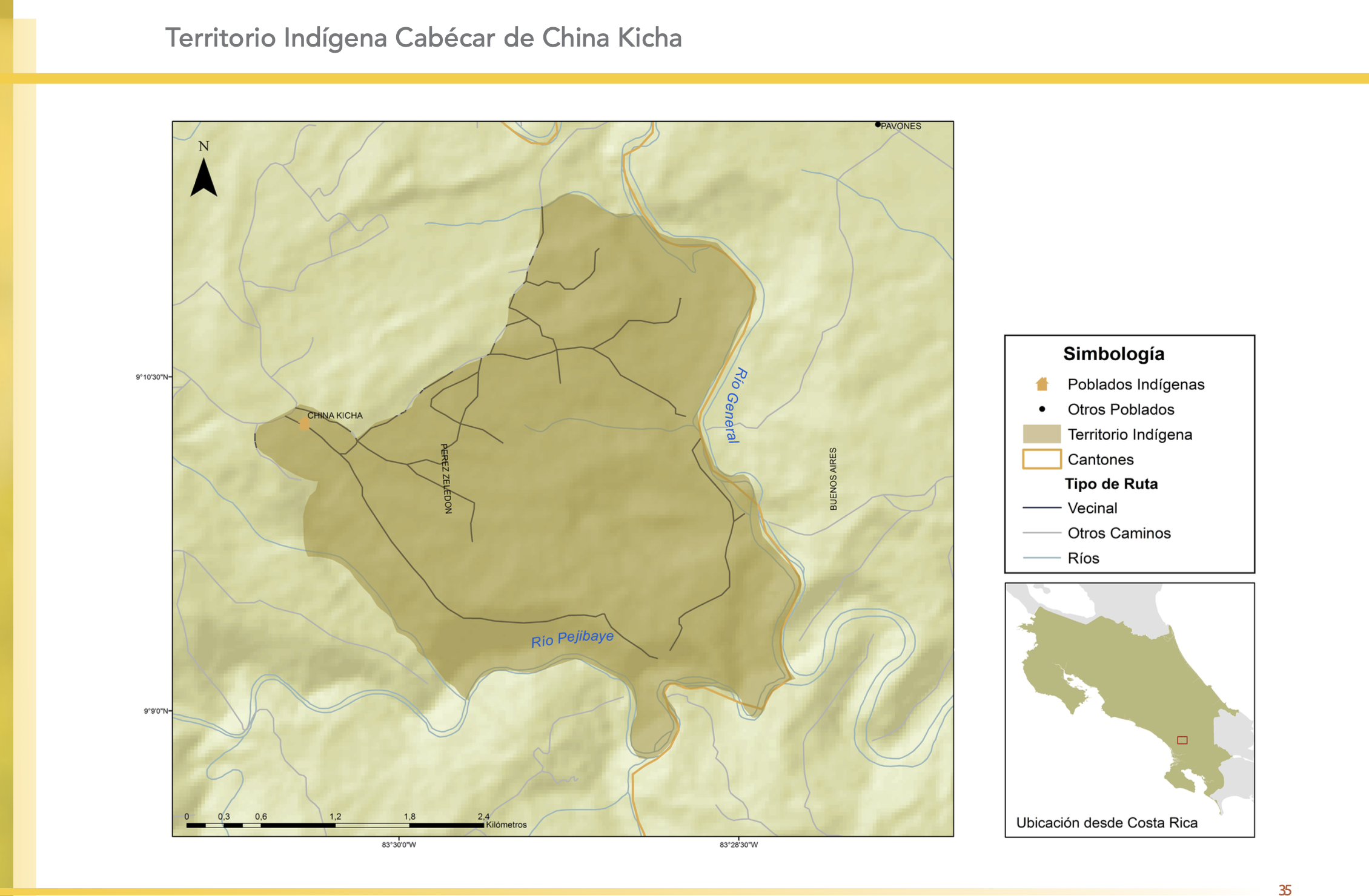
Dispossesions in the Americas

Dispossesions in the Americas

  • Home
  • Explore
  • About
  • Authors
  • Art
  • Bodies
  • Curricula
  • Cultural Heritage
  • Maps
  • Territories
Back to Explore
Map 2010

"Territorio Indígena Cabécar de China Kicha"

  • GÓMEZ ET AL.

Published: 2014

  • Download Image

Peoples

  • CABECAR DE CHINA KICHA

Citation

Gómez Meléndez, Agustín, Felipe González Evora, Heiddys García, Marco      Espinoza, and Fabián Solano Monge. Atlas de territorios      indígenas--Universidad de Costa Rica. Costa Rica: Universidad de Costa      Rica, 2014.         https://hdl.handle.net/10669/15098

  • Download Image

Reading in Spanish

Map 2010

"Territorio Indígena Cabécar de China Kicha"

  • GÓMEZ ET AL.

Published: 2014

  • Download Image
  • Download Image

Reading in Portuguese

Map 2010

"Territorio Indígena Cabécar de China Kicha"

  • GÓMEZ ET AL.

Published: 2014

  • Download Image

Peoples

  • CABECAR DE CHINA KICHA

Citation

Gómez Meléndez, Agustín, Felipe González Evora, Heiddys García, Marco      Espinoza, and Fabián Solano Monge. Atlas de territorios      indígenas--Universidad de Costa Rica. Costa Rica: Universidad de Costa      Rica, 2014.         https://hdl.handle.net/10669/15098

  • Download Image

Related Content

PUEBLO JAKALTECO

PUEBLO JAKALTECO

Map 2020
PUEBLO ZAPATECO

PUEBLO ZAPATECO

Map 2020
Población mahkurawe (guarijío) en 2010

Población mahkurawe (guarijío) en 2010

Map 2010
Carta particolare dell'India Ocidentale;con la terra ferma dal' capo di Paria sin al' capo S. Romano

Carta particolare dell'India Ocidentale;con la terra ferma dal' capo di Paria sin al' capo S. Romano

Map 1661
TRENTA LEGHE (166 CHILOMETRI) DELL’ ITAMBE’ GUAZÙ

TRENTA LEGHE (166 CHILOMETRI) DELL’ ITAMBE’ GUAZÙ

Map 1884
Jivaro country in Sad America

Jivaro country in Sad America

Map 1976 - 1978
Origin of Mayans according to HLA genes and the uniqueness

Origin of Mayans according to HLA genes and the uniqueness

Map
Government map of Nicaragua : from the latest surveys ordered by President Patricio Rivas and Genl. William Walker ;executed under the supervision of the Señor Fermín Ferrer;Governor of the Western Department;1856

Government map of Nicaragua : from the latest surveys ordered by President Patricio Rivas and Genl. William Walker ;executed under the supervision of the Señor Fermín Ferrer;Governor of the Western Department;1856

Map 1800 - 1856

Dispossessions in the Americas

A project by

University of Pennsylvania

Copyright 2024

With support from

Mellon Foundation

Site design & development

Element 84

Art Credits

Gómez Meléndez, Agustín, Felipe González Evora, Heiddys García, Marco      Espinoza, and Fabián Solano Monge. Atlas de territorios      indígenas–Universidad de Costa Rica. Costa Rica: Universidad de Costa      Rica, 2014.         https://hdl.handle.net/10669/15098

Site Pages

  • Home
  • Explore
  • About
  • Authors
  • Art
  • Bodies
  • Curricula
  • Cultural Heritage
  • Maps
  • Territories