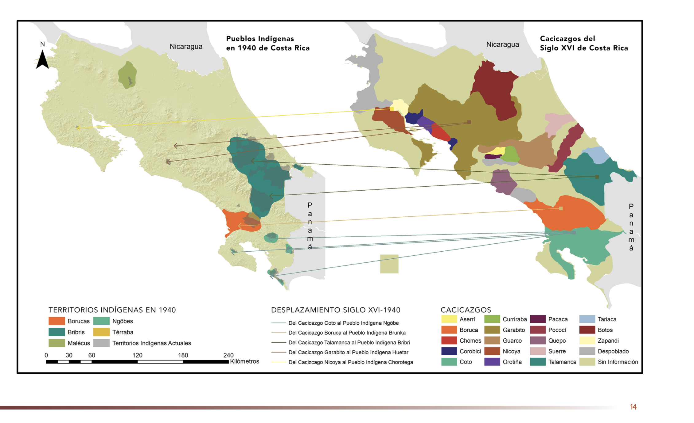
Dispossesions in the Americas

Dispossesions in the Americas

  • Home
  • Explore
  • About
  • Authors
  • Art
  • Bodies
  • Curricula
  • Cultural Heritage
  • Maps
  • Territories
Back to Explore
Map 1500 - 1899

"Pueblos Indígenas 1940 y Cacicazgos del Siglo XVI de Costa Rica"

  • GÓMEZ ET AL.

Published: 2014

  • Download Image

Peoples

  • BORUCAS
  • BRIBRIS
  • MALECUS
  • NGOBES
  • TERRABA
  • ASERRI
  • BORUCA
  • CHOMES
  • COROBICI
  • COTO
  • CUIRRABA
  • GARABITO
  • GUARCO
  • NICOYA
  • OROTINA
  • PACACA
  • POCOCI
  • QUEPO
  • SUERRE
  • TALAMANCA
  • TARIACA
  • BOTOS
  • ZAPANDI

Citation

Gómez Meléndez, Agustín, Felipe González Evora, Heiddys García, Marco      Espinoza, and Fabián Solano Monge. Atlas de territorios      indígenas--Universidad de Costa Rica. Costa Rica: Universidad de Costa      Rica, 2014.         https://hdl.handle.net/10669/15088

  • Download Image

Reading in Spanish

Map 1500 - 1899

"Pueblos Indígenas 1940 y Cacicazgos del Siglo XVI de Costa Rica"

  • GÓMEZ ET AL.

Published: 2014

  • Download Image
  • Download Image

Related Content

Nuremberg Map of Tenochititlan and the Gulf Coast, 1524

Nuremberg Map of Tenochititlan and the Gulf Coast, 1524

Map 1524
Terra Indígena Itaóca

Terra Indígena Itaóca

Map 2012
Plano de las tierras del Convento de Predicadores del Valle del Santo Ecce Homo, parroquia del Cocuy.

Plano de las tierras del Convento de Predicadores del Valle del Santo Ecce Homo, parroquia del Cocuy.

Map 1822
PUEBLO AMUZGO

PUEBLO AMUZGO

Map 2020
Amerique Méridionale, Dressée, sur les Mémoires les plus récents et assujétie aux observations astronomique

Amerique Méridionale, Dressée, sur les Mémoires les plus récents et assujétie aux observations astronomique

Map 1786
Government map of Nicaragua : from the latest surveys ordered by President Patricio Rivas and Genl. William Walker ;executed under the supervision of the Señor Fermín Ferrer;Governor of the Western Department;1856

Government map of Nicaragua : from the latest surveys ordered by President Patricio Rivas and Genl. William Walker ;executed under the supervision of the Señor Fermín Ferrer;Governor of the Western Department;1856

Map 1800 - 1856
PRIMERAS CULTURAS QUITENAS - LA AMAZONIA - GENEALOGÍA - INVASIONES MAYAS

PRIMERAS CULTURAS QUITENAS - LA AMAZONIA - GENEALOGÍA - INVASIONES MAYAS

Map
"Territorio Indígena Matambú (Chorotega)"

"Territorio Indígena Matambú (Chorotega)"

Map 2010

Dispossessions in the Americas

A project by

University of Pennsylvania

Copyright 2024

With support from

Mellon Foundation

Site design & development

Element 84

Art Credits

Gómez Meléndez, Agustín, Felipe González Evora, Heiddys García, Marco      Espinoza, and Fabián Solano Monge. Atlas de territorios      indígenas–Universidad de Costa Rica. Costa Rica: Universidad de Costa      Rica, 2014.         https://hdl.handle.net/10669/15088

Site Pages

  • Home
  • Explore
  • About
  • Authors
  • Art
  • Bodies
  • Curricula
  • Cultural Heritage
  • Maps
  • Territories