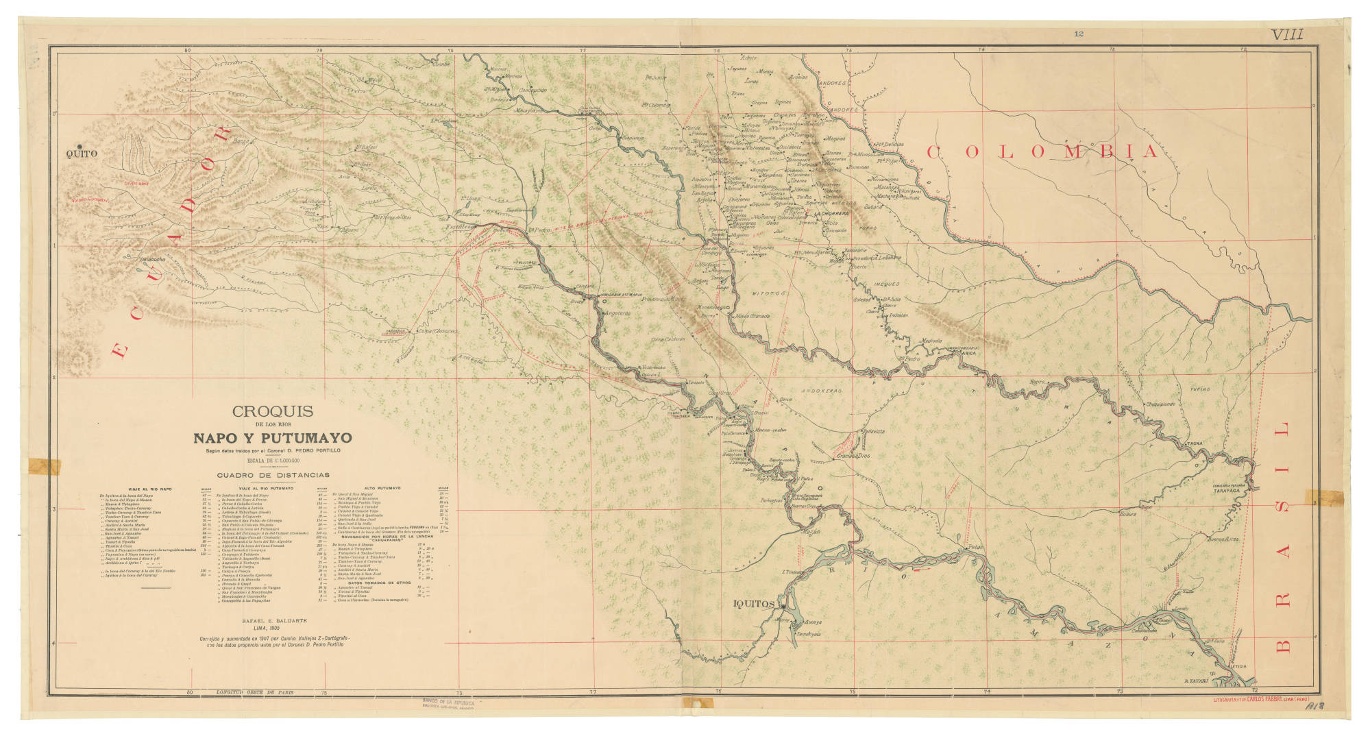
Dispossesions in the Americas

Dispossesions in the Americas

  • Home
  • Explore
  • About
  • Authors
  • Art
  • Bodies
  • Curricula
  • Cultural Heritage
  • Maps
  • Territories
Back to Explore
Map 1905

CROQUIS DE LOS RÍOS NAPO Y PUTUMAYO Según datos traídos por el Coronel D. PEDRO PORTILLO

  • BALUARTE, RAFAEL E, ET AL.

Published: 1905

  • Download Image

Peoples

  • ANDOKES
  • WITOTOS
  • PORAS
  • ANDOKERAS
  • YURIAS

Citation

Baluarte, R., Vallejos, Z., & Camilo Portillo, P. Croquis de los ríos Napo y Putumayo: según datos traídos por el Coronel D. Pedro Portillo [Map]. 1905 Red de Bibliotecas del Banco de la República en Colombia. https://babel.banrepcultural.org/digital/collection/p17054coll13/id/156/rec/1

  • Download Image

Reading in Spanish

Map 1905

CROQUIS DE LOS RÍOS NAPO Y PUTUMAYO Según datos traídos por el Coronel D. PEDRO PORTILLO

  • BALUARTE, RAFAEL E, ET AL.

Published: 1905

  • Download Image
  • Download Image

Reading in Portuguese

Map 1905

CROQUIS DE LOS RÍOS NAPO Y PUTUMAYO Según datos traídos por el Coronel D. PEDRO PORTILLO

  • BALUARTE, RAFAEL E, ET AL.

Published: 1905

  • Download Image

Peoples

  • ANDOKES
  • WITOTOS
  • PORAS
  • ANDOKERAS
  • YURIAS

Citation

Baluarte, R., Vallejos, Z., & Camilo Portillo, P. Croquis de los ríos Napo y Putumayo: según datos traídos por el Coronel D. Pedro Portillo [Map]. 1905 Red de Bibliotecas del Banco de la República en Colombia. https://babel.banrepcultural.org/digital/collection/p17054coll13/id/156/rec/1

  • Download Image

Related Content

XXXVI. Carte de la Guiane Francaise et Hollandaise. Dressée d'aprés les Cartes de N. Buache et de Simon Mentelle Capitaine d'Infanterie;Darde du Dépôt des Cartes et Plans de la Colonie de Cayenne.

XXXVI. Carte de la Guiane Francaise et Hollandaise. Dressée d'aprés les Cartes de N. Buache et de Simon Mentelle Capitaine d'Infanterie;Darde du Dépôt des Cartes et Plans de la Colonie de Cayenne.

Map 1800 - 1899
Carte de la Coste de Cayenne.

Carte de la Coste de Cayenne.

Map 1600 - 1699
Venezuela, Colombia, Ecuador;British, Dutch, and French Guiana

Venezuela, Colombia, Ecuador;British, Dutch, and French Guiana

Map 1901
MAPPA DA PROVINCIA DE MINAS GERAES

MAPPA DA PROVINCIA DE MINAS GERAES

Map 1826
Carte du gouvernement de Cayenne dans l'Amerique méridionale.

Carte du gouvernement de Cayenne dans l'Amerique méridionale.

Map 1696
REGIÓN MONTANA DE GUERRERO

REGIÓN MONTANA DE GUERRERO

Map 2000
SAN LUIS POTOSÍ

SAN LUIS POTOSÍ

Map 2015
TAMÁRÃHO

TAMÁRÃHO

Map 2015

Dispossessions in the Americas

A project by

University of Pennsylvania

Copyright 2024

With support from

Mellon Foundation

Site design & development

Element 84

Art Credits

Baluarte, R., Vallejos, Z., & Camilo Portillo, P. Croquis de los ríos Napo y Putumayo: según datos traídos por el Coronel D. Pedro Portillo [Map]. 1905 Red de Bibliotecas del Banco de la República en Colombia. https://babel.banrepcultural.org/digital/collection/p17054coll13/id/156/rec/1

Site Pages

  • Home
  • Explore
  • About
  • Authors
  • Art
  • Bodies
  • Curricula
  • Cultural Heritage
  • Maps
  • Territories