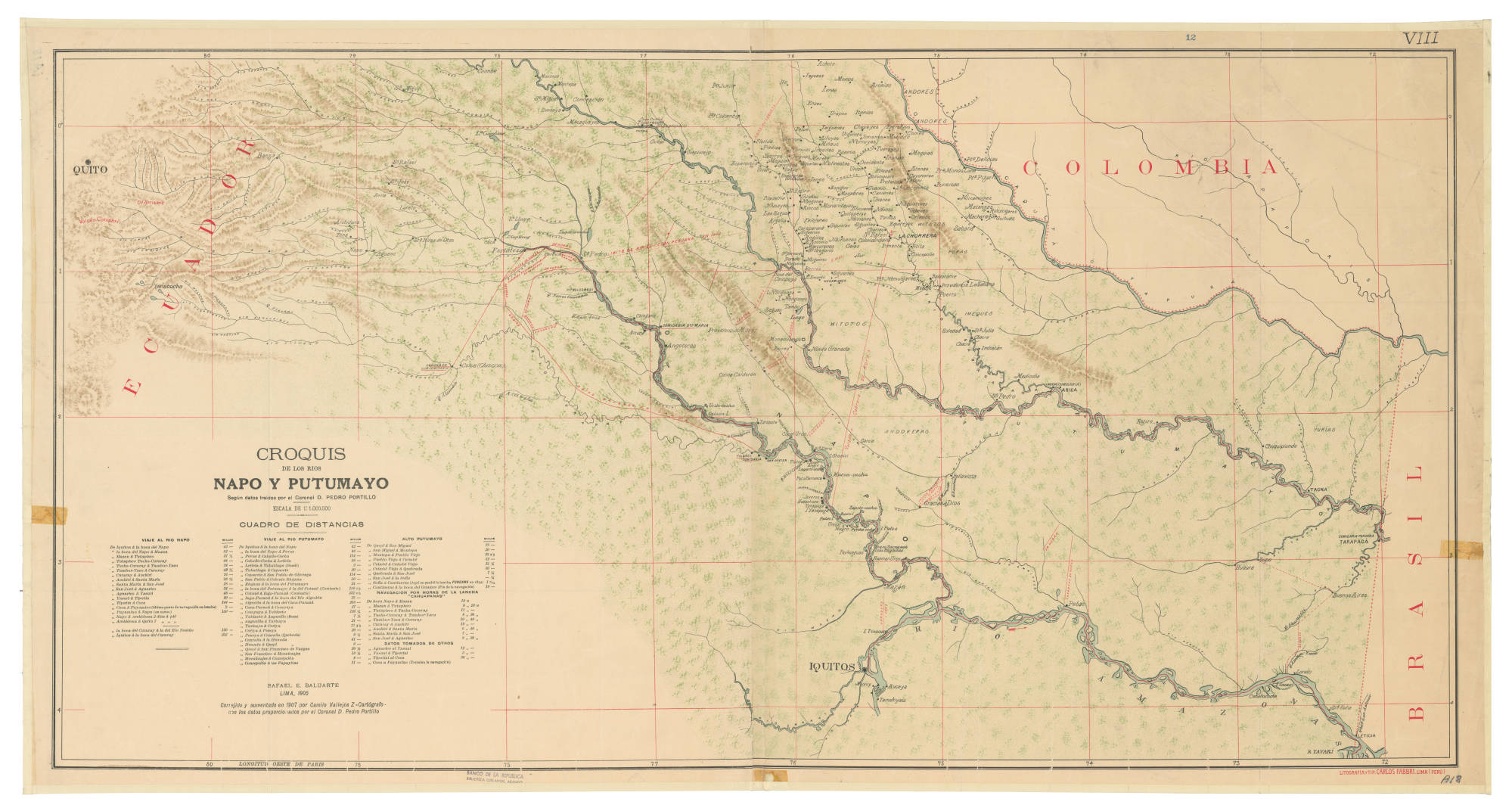
Dispossesions in the Americas

Dispossesions in the Americas

  • Home
  • Explore
  • About
  • Authors
  • Art
  • Bodies
  • Curricula
  • Cultural Heritage
  • Maps
  • Territories
Back to Explore
Map 1905

CROQUIS DE LOS RÍOS NAPO Y PUTUMAYO Según datos traídos por el Coronel D. PEDRO PORTILLO

  • BALUARTE, RAFAEL E, ET AL.

Published: 1905

  • Download Image

Peoples

  • ANDOKES
  • WITOTOS
  • PORAS
  • ANDOKERAS
  • YURIAS

Citation

Baluarte, R., Vallejos, Z., & Camilo Portillo, P. Croquis de los ríos Napo y Putumayo: según datos traídos por el Coronel D. Pedro Portillo [Map]. 1905 Red de Bibliotecas del Banco de la República en Colombia. https://babel.banrepcultural.org/digital/collection/p17054coll13/id/156/rec/1

  • Download Image

Reading in Spanish

Map 1905

CROQUIS DE LOS RÍOS NAPO Y PUTUMAYO Según datos traídos por el Coronel D. PEDRO PORTILLO

  • BALUARTE, RAFAEL E, ET AL.

Published: 1905

  • Download Image
  • Download Image

Related Content

Carte de la partie de l'Yucatan concedée aux Anglais: [traités de 1783 et 1786].

Carte de la partie de l'Yucatan concedée aux Anglais: [traités de 1783 et 1786].

Map 1783 - 1786
No nos culpes por lo que pasó [Do not blame us fow what happened]

No nos culpes por lo que pasó [Do not blame us fow what happened]

Artwork
PUEBLO MAM

PUEBLO MAM

Map
VISTA DE LA NUEVA POBLACION DE SAN FERNANDO DE GUADALUPE EN EL SALTO DE AGUA DEL RIO TULIJA, QUE LLEVA SU CORRIENTE A LAS LAGUNAS DE CHICHICASTE Y DE TÉRMINOS

VISTA DE LA NUEVA POBLACION DE SAN FERNANDO DE GUADALUPE EN EL SALTO DE AGUA DEL RIO TULIJA, QUE LLEVA SU CORRIENTE A LAS LAGUNAS DE CHICHICASTE Y DE TÉRMINOS

Map 1795
San Jose

San Jose

Map 1997
Map of Sonora, Showing Historic Location of Pima Bajo, Opata, Papago, and Seri Indians in 1960

Map of Sonora, Showing Historic Location of Pima Bajo, Opata, Papago, and Seri Indians in 1960

Map 1960
Mexico at the time of the conquest (1519), showing the extent of the Culhua Mexica (Aztec Empire) and of the Maya holdings

Mexico at the time of the conquest (1519), showing the extent of the Culhua Mexica (Aztec Empire) and of the Maya holdings

Map 1519
Matrimonios Duitama

Matrimonios Duitama

Map 1500 - 1600

Dispossessions in the Americas

A project by

University of Pennsylvania

Copyright 2024

With support from

Mellon Foundation

Site design & development

Element 84

Art Credits

Baluarte, R., Vallejos, Z., & Camilo Portillo, P. Croquis de los ríos Napo y Putumayo: según datos traídos por el Coronel D. Pedro Portillo [Map]. 1905 Red de Bibliotecas del Banco de la República en Colombia. https://babel.banrepcultural.org/digital/collection/p17054coll13/id/156/rec/1

Site Pages

  • Home
  • Explore
  • About
  • Authors
  • Art
  • Bodies
  • Curricula
  • Cultural Heritage
  • Maps
  • Territories