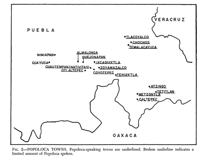
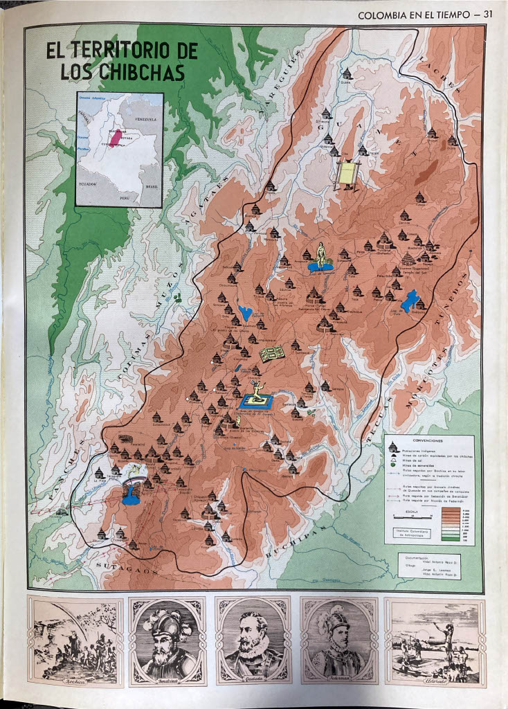
Dispossesions in the Americas

Dispossesions in the Americas

  • Home
  • Explore
  • About
  • Authors
  • Art
  • Bodies
  • Curricula
  • Cultural Heritage
  • Maps
  • Territories
Back to Explore
Map 1500 - 1599

El Territorio de los Chibchas

  • Jorge E. Lesmes;Antonio Rozo Vidal. (Information from the Instituto Colombiano de Antropologia)

Published: 1969

  • Download Image

Peoples

  • AGATAES
  • BUCHIPAS
  • COLIMAS
  • GUANES
  • LACHES
  • MORCOTES
  • MUISCA
  • MUZOS
  • PANCHES
  • SUTAGAOS
  • TECUAS
  • YARIGUIES

Citation

Acevedo Latorre, Eduardo. Atlas de Colombia. Bogotá: Instituto Geográfico Agustín Codazzi, 1969, p. 31.

  • Download Image

Reading in Spanish

Map 1500 - 1599

El Territorio de los Chibchas

  • Jorge E. Lesmes;Antonio Rozo Vidal. (Information from the Instituto Colombiano de Antropologia)

Published: 1969

  • Download Image
  • Download Image

Related Content

The indigenous language groups  of Baja California at contact

The indigenous language groups of Baja California at contact

Map 1530
Location of Nahuat Area on Gulf Coast Plain

Location of Nahuat Area on Gulf Coast Plain

Map 1969
La Guyane Francoise, avec partie de la Guyane Hollandoise: suivant les Opérations et les Cartes récentes;des Ingênieurs-Géographes François.

La Guyane Francoise, avec partie de la Guyane Hollandoise: suivant les Opérations et les Cartes récentes;des Ingênieurs-Géographes François.

Map 1787
Map of Nicaragua showing Ulwa settlements in Eastern Nicaragua and field study sites (in rectangle)

Map of Nicaragua showing Ulwa settlements in Eastern Nicaragua and field study sites (in rectangle)

Map 1990
PROVINCIE DEL PARA E DEL MARAGNONE

PROVINCIE DEL PARA E DEL MARAGNONE

Map 1600 - 1699
CARTA COROGRÁFICA DE JALISCO, ZACATECAS Y COLIMA

CARTA COROGRÁFICA DE JALISCO, ZACATECAS Y COLIMA

Map 1824
PUEBLO KANDOZI

PUEBLO KANDOZI

Map 2021
K. GUIANA. I. DAS BRITISCHE, II. [DAS] NIEDERLAENDISCHE, III. [DAS FRANZÖSISCHE.]

K. GUIANA. I. DAS BRITISCHE, II. [DAS] NIEDERLAENDISCHE, III. [DAS FRANZÖSISCHE.]

Map 1800 - 1899

Dispossessions in the Americas

A project by

University of Pennsylvania

Copyright 2024

With support from

Mellon Foundation

Site design & development

Element 84

Art Credits

Acevedo Latorre, Eduardo. Atlas de Colombia. Bogotá: Instituto Geográfico Agustín Codazzi, 1969, p. 31.

Site Pages

  • Home
  • Explore
  • About
  • Authors
  • Art
  • Bodies
  • Curricula
  • Cultural Heritage
  • Maps
  • Territories