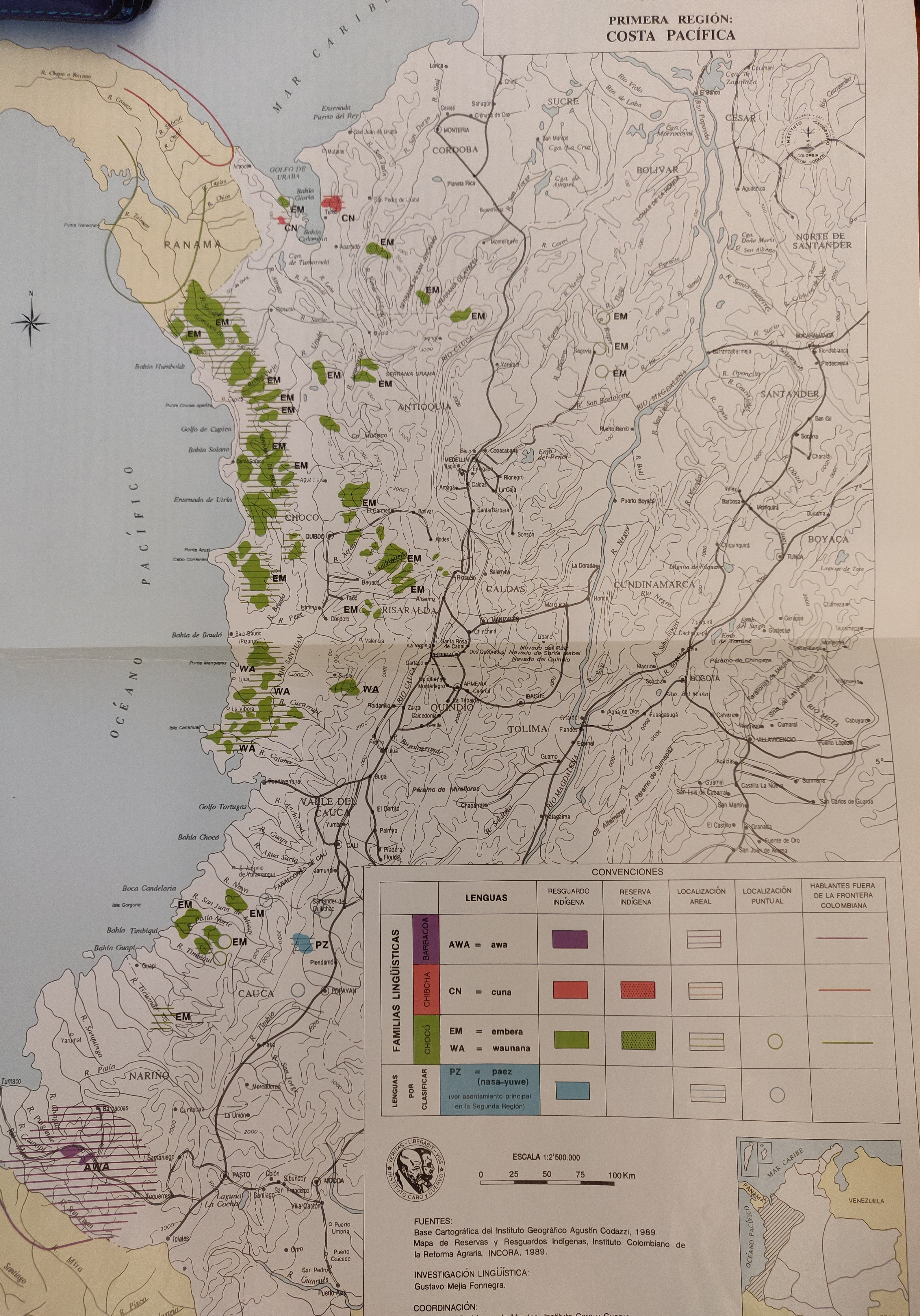
Dispossesions in the Americas

Dispossesions in the Americas

  • Home
  • Explore
  • About
  • Authors
  • Art
  • Bodies
  • Curricula
  • Cultural Heritage
  • Maps
  • Territories
Back to Explore
Map 1989

FAMILIAS LINGUISTICAS Y LENGUAS INDIGENAS - PRIMERA REGION: COSTA PACIFICA

  • INSTITUTO GEOGRAFICO AGUSTIN CODAZZI

Published: 1989

  • Download Image

Peoples

  • AWA
  • CUNA
  • EMBERA
  • WAUNANA
  • PAEZ

Citation

Maria Stella Gonzalez de Perez y Maria Luisa Rodriguez de Montes (2000), "Lenguas Indigenas de Colombia," Instituto Caro y Cuervo, Bogota. 1989 (Familias Linguísticas y Lenguas Indígenas - Primera región: Costa Pacífica, p. 54)

  • Download Image

Reading in Spanish

Map 1989

FAMILIAS LINGUISTICAS Y LENGUAS INDIGENAS - PRIMERA REGION: COSTA PACIFICA

  • INSTITUTO GEOGRAFICO AGUSTIN CODAZZI

Published: 1989

  • Download Image
  • Download Image

Reading in Portuguese

Map 1989

FAMILIAS LINGUISTICAS Y LENGUAS INDIGENAS - PRIMERA REGION: COSTA PACIFICA

  • INSTITUTO GEOGRAFICO AGUSTIN CODAZZI

Published: 1989

  • Download Image

Peoples

  • AWA
  • CUNA
  • EMBERA
  • WAUNANA
  • PAEZ

Citation

Maria Stella Gonzalez de Perez y Maria Luisa Rodriguez de Montes (2000), "Lenguas Indigenas de Colombia," Instituto Caro y Cuervo, Bogota. 1989 (Familias Linguísticas y Lenguas Indígenas - Primera región: Costa Pacífica, p. 54)

  • Download Image

Related Content

Northern Tepehuan Area, Chihuahua

Northern Tepehuan Area, Chihuahua

Map 1969
Carte de la Goÿanne francoise depuis le fort de Barou et la Rre. D'yari, jusqua Maroni ou on voit les principaux établissements des Francois tant das l'isle de Caÿenne que dans la terre ferme, avec les noms des nations indienne qui habitent et les missions que le RR.PP y ont établies.

Carte de la Goÿanne francoise depuis le fort de Barou et la Rre. D'yari, jusqua Maroni ou on voit les principaux établissements des Francois tant das l'isle de Caÿenne que dans la terre ferme, avec les noms des nations indienne qui habitent et les missions que le RR.PP y ont établies.

Map 1741
MAPA ETNO-HISTÓRICO DO BRASIL E REGIÕES ADJACENTES

MAPA ETNO-HISTÓRICO DO BRASIL E REGIÕES ADJACENTES

Map 1400 - 1944
Distribución histórica de las poblaciones indígenas según la familia lingüística

Distribución histórica de las poblaciones indígenas según la familia lingüística

Map 1490
LA GRAN CIVDAD I CAVEsa y corte rreal de los doze rreys Yngas, Santiago del Cuzco en medio del rreyno y obispado

LA GRAN CIVDAD I CAVEsa y corte rreal de los doze rreys Yngas, Santiago del Cuzco en medio del rreyno y obispado

Map 1615
Mbyá

Mbyá

Map 2001
CARTE DU THÉÂTRE DE LA GUERRE ENTRE LE BRÉSIL, LA CONFÉDÉRATION ARGENTINE, LA RÉPUBLIQUE DE L'URUGUAY & LE PARAGUAY

CARTE DU THÉÂTRE DE LA GUERRE ENTRE LE BRÉSIL, LA CONFÉDÉRATION ARGENTINE, LA RÉPUBLIQUE DE L'URUGUAY & LE PARAGUAY

Map 1864 - 1865
Santa Elena and Pueblo Viejo

Santa Elena and Pueblo Viejo

Map 1997

Dispossessions in the Americas

A project by

University of Pennsylvania

Copyright 2024

With support from

Mellon Foundation

Site design & development

Element 84

Art Credits

Maria Stella Gonzalez de Perez y Maria Luisa Rodriguez de Montes (2000), “Lenguas Indigenas de Colombia,” Instituto Caro y Cuervo, Bogota. 1989 (Familias Linguísticas y Lenguas Indígenas - Primera región: Costa Pacífica, p. 54)

Site Pages

  • Home
  • Explore
  • About
  • Authors
  • Art
  • Bodies
  • Curricula
  • Cultural Heritage
  • Maps
  • Territories