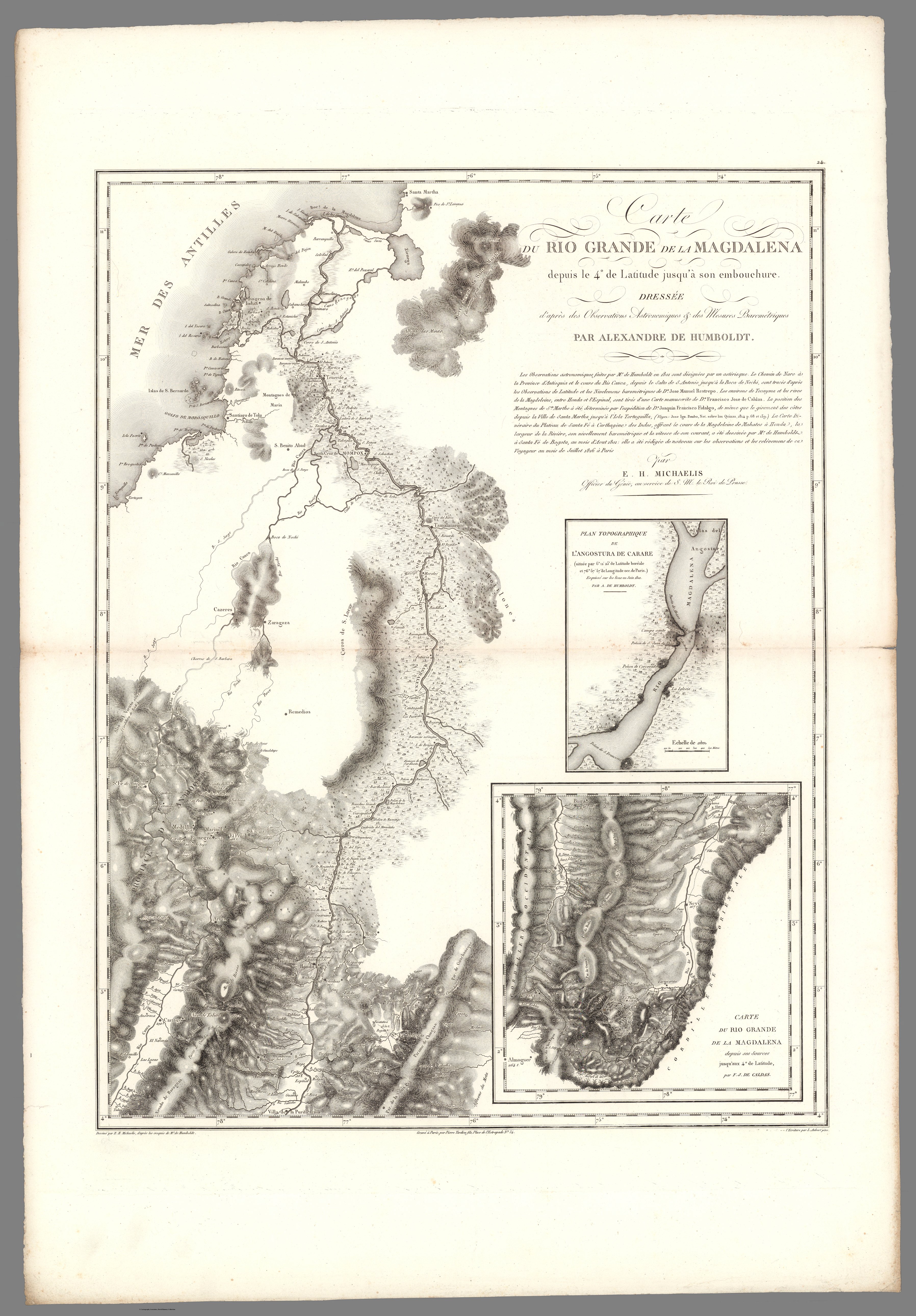
Dispossesions in the Americas

Dispossesions in the Americas

  • Home
  • Explore
  • About
  • Authors
  • Art
  • Bodies
  • Curricula
  • Cultural Heritage
  • Maps
  • Territories
Back to Explore
Map 1799 - 1804

XXIV. Carte du Rio Grande de la Magdalena, depuis ses sources jusqu'a son embouchure.

  • Alexandre de Humboldt;Aime Bonpland

Published: 1831

  • Download Image

Peoples

  • MOTILONES

Citation

Voyage de MM. Alexandre de Humboldt et Aime Bonpland. Atlas Geographique et Physique, pour Accompagner la Relation Historique. Sixieme livraison. Paris, J. Smith, Rue Montmorency, No. 16;Londres, Dulau et Compie., Soho-Square. 1831. Imprimerie de J. Smith. https://www.davidrumsey.com/luna/servlet/detail/RUMSEY~8~1~292872~90064417:XXIV--Carte-du-Rio-Grande-de-la-Mag?sort=Pub_List_No_InitialSort&qvq=q:colombia;sort:Pub_List_No_InitialSort;lc:RUMSEY~8~1&mi=207&trs=457#

  • Download Image

Reading in Spanish

Map 1799 - 1804

XXIV. Carte du Rio Grande de la Magdalena, depuis ses sources jusqu'a son embouchure.

  • Alexandre de Humboldt;Aime Bonpland

Published: 1831

  • Download Image
  • Download Image

Reading in Portuguese

Map 1799 - 1804

XXIV. Carte du Rio Grande de la Magdalena, depuis ses sources jusqu'a son embouchure.

  • Alexandre de Humboldt;Aime Bonpland

Published: 1831

  • Download Image

Peoples

  • MOTILONES

Citation

Voyage de MM. Alexandre de Humboldt et Aime Bonpland. Atlas Geographique et Physique, pour Accompagner la Relation Historique. Sixieme livraison. Paris, J. Smith, Rue Montmorency, No. 16;Londres, Dulau et Compie., Soho-Square. 1831. Imprimerie de J. Smith. https://www.davidrumsey.com/luna/servlet/detail/RUMSEY~8~1~292872~90064417:XXIV--Carte-du-Rio-Grande-de-la-Mag?sort=Pub_List_No_InitialSort&qvq=q:colombia;sort:Pub_List_No_InitialSort;lc:RUMSEY~8~1&mi=207&trs=457#

  • Download Image

Related Content

The Island and Colony of Cayenne subject to the French, on the Continent of South America.

The Island and Colony of Cayenne subject to the French, on the Continent of South America.

Map 1760
THE CARACAS

THE CARACAS

Map 1810
Descripciones geograficas de muchas tierras y mares del Norte y Sur en las Indias

Descripciones geograficas de muchas tierras y mares del Norte y Sur en las Indias

Map 1613 - 1615
CARTA DO RIO IÇA

CARTA DO RIO IÇA

Map 1868
Map of Nicaragua showing Ulwa settlements in Eastern Nicaragua and field study sites (in rectangle)

Map of Nicaragua showing Ulwa settlements in Eastern Nicaragua and field study sites (in rectangle)

Map 1990
MULTI-ETHNIC TERRITORY under INCA DIRECT RULE: THE CENTRAL AND UPPER VALLEYS OF COCHABAMBA in the 1530s

MULTI-ETHNIC TERRITORY under INCA DIRECT RULE: THE CENTRAL AND UPPER VALLEYS OF COCHABAMBA in the 1530s

Map 1520
Geographic Distribution of Huichol and Cora, Showing State Names

Geographic Distribution of Huichol and Cora, Showing State Names

Map 1969
Otoxha

Otoxha

Map 1997

Dispossessions in the Americas

A project by

University of Pennsylvania

Copyright 2024

With support from

Mellon Foundation

Site design & development

Element 84

Art Credits

Voyage de MM. Alexandre de Humboldt et Aime Bonpland. Atlas Geographique et Physique, pour Accompagner la Relation Historique. Sixieme livraison. Paris, J. Smith, Rue Montmorency, No. 16;Londres, Dulau et Compie., Soho-Square. 1831. Imprimerie de J. Smith. https://www.davidrumsey.com/luna/servlet/detail/RUMSEY~8~1~292872~90064417:XXIV--Carte-du-Rio-Grande-de-la-Mag?sort=Pub_List_No_InitialSort&qvq=q:colombia;sort:Pub_List_No_InitialSort;lc:RUMSEY~8~1&mi=207&trs=457#

Site Pages

  • Home
  • Explore
  • About
  • Authors
  • Art
  • Bodies
  • Curricula
  • Cultural Heritage
  • Maps
  • Territories