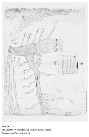
Dispossesions in the Americas

Dispossesions in the Americas

  • Home
  • Explore
  • About
  • Authors
  • Art
  • Bodies
  • Curricula
  • Cultural Heritage
  • Maps
  • Territories
Back to Explore
Map 1759

MAPA 1: RIO ATRATO Y PUEBLOS DE INDIOS CUNA-CUNAS

  • UNKOWN

Published: 1759

  • Download Image

Peoples

  • CUNUCUNAS

Citation

VASQUEZ PINO, DANIELA. 'Los Yndios Infieles Han Quebrantado la Paz'. Negotiations between European, Chocoes and Cunas in Darien, 1739-1789. Fronteras de la historia, 2015, vol.20, n.2, pp.14-42. ISSN 2027-4688. ( http://www.scielo.org.co/scielo.php?script=sci_abstract&pid=S2027-46882015000200001)."Mapa1.MapadelazonacomprendidaentrelacostayelAtratohastaQuibdóylalocalizacióndelosindioscunacunas."31x42cm.A-347-1759.A.G.N.,Colonia"Caciqueseindios",t.58,fol.559.Mapotecanúm.4 (103AVC.139),SantafédeBogotá(Colombia).

  • Download Image

Reading in Spanish

Map 1759

MAPA 1: RIO ATRATO Y PUEBLOS DE INDIOS CUNA-CUNAS

  • UNKOWN

Published: 1759

  • Download Image
  • Download Image

Related Content

Carte géographique de l'isle de Cayenne et de ses environs dressée sur les observations estimées et les remarques de Mr de Préfontaine

Carte géographique de l'isle de Cayenne et de ses environs dressée sur les observations estimées et les remarques de Mr de Préfontaine

Map 1747 - 1762
San Marcos

San Marcos

Map 1997
O. DIE REP: ARGENTINA. P. DAS DICTATORAT PARAGUAY.

O. DIE REP: ARGENTINA. P. DAS DICTATORAT PARAGUAY.

Map 1830
The Boundaries of Cuauhtinchan and Totomihuacan, Historia Tolteca-Chichimeca, pp. 1-2

The Boundaries of Cuauhtinchan and Totomihuacan, Historia Tolteca-Chichimeca, pp. 1-2

Map 1560
Guyanes. Amér. Mérid. no. 7. (Dresse par Ph. Vandermaelen, lithographie par H. Ode. Cinquième partie. - Amer. merid. Bruxelles. 1827)

Guyanes. Amér. Mérid. no. 7. (Dresse par Ph. Vandermaelen, lithographie par H. Ode. Cinquième partie. - Amer. merid. Bruxelles. 1827)

Map 1800 - 1899
PUEBLO TARAHUMARA

PUEBLO TARAHUMARA

Map 2020
Mbyá

Mbyá

Map 2001
Prehispanic Distribution of the Otomí Family

Prehispanic Distribution of the Otomí Family

Map 1969

Dispossessions in the Americas

A project by

University of Pennsylvania

Copyright 2024

With support from

Mellon Foundation

Site design & development

Element 84

Art Credits

VASQUEZ PINO, DANIELA. ‘Los Yndios Infieles Han Quebrantado la Paz’. Negotiations between European, Chocoes and Cunas in Darien, 1739-1789. Fronteras de la historia, 2015, vol.20, n.2, pp.14-42. ISSN 2027-4688. ( http://www.scielo.org.co/scielo.php?script=sci_abstract&pid=S2027-46882015000200001)."Mapa1.MapadelazonacomprendidaentrelacostayelAtratohastaQuibdóylalocalizacióndelosindioscunacunas.“31x42cm.A-347-1759.A.G.N.,Colonia"Caciqueseindios",t.58,fol.559.Mapotecanúm.4 (103AVC.139),SantafédeBogotá(Colombia).

Site Pages

  • Home
  • Explore
  • About
  • Authors
  • Art
  • Bodies
  • Curricula
  • Cultural Heritage
  • Maps
  • Territories