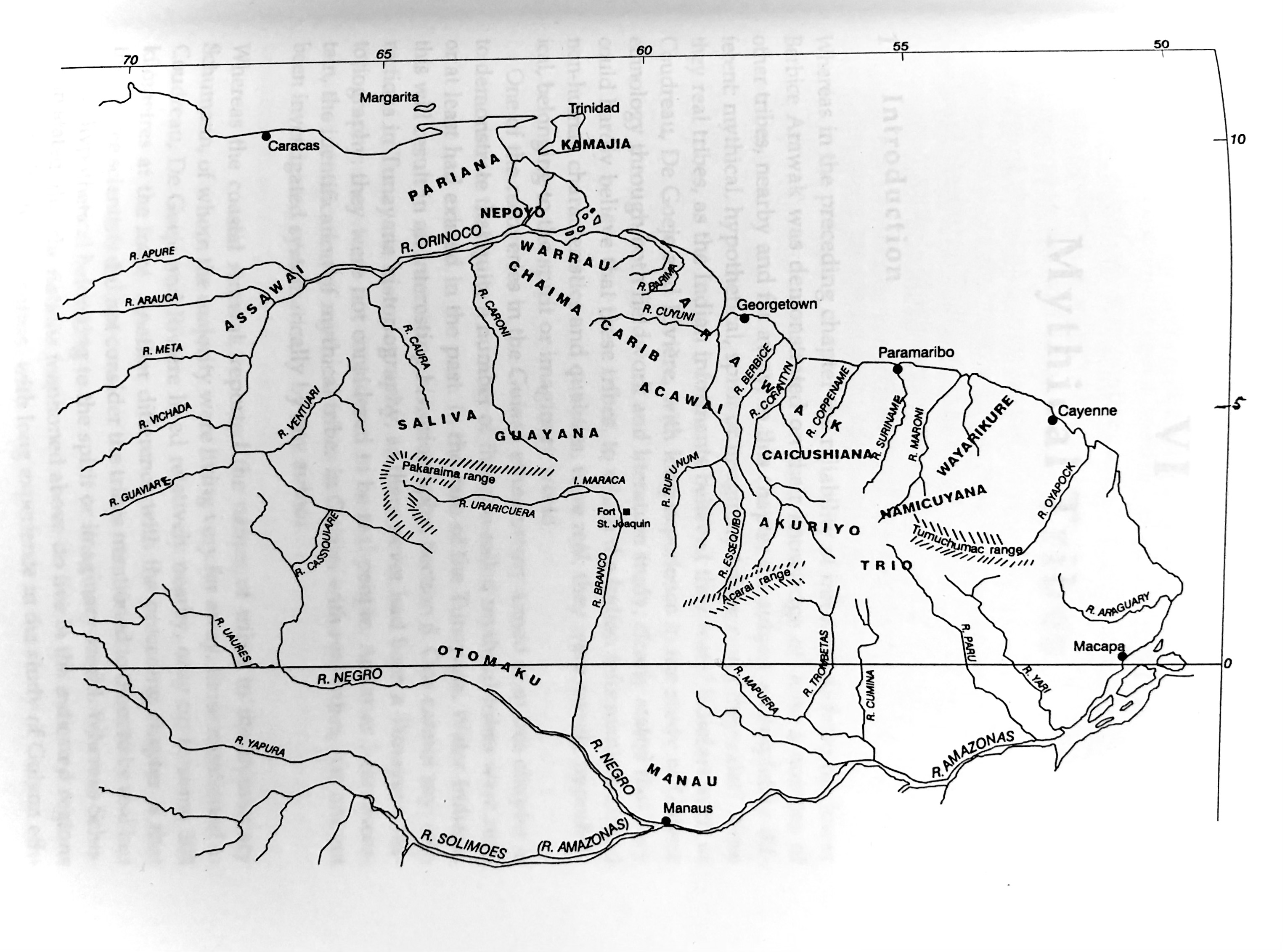
Dispossesions in the Americas

Dispossesions in the Americas

  • Home
  • Explore
  • About
  • Authors
  • Art
  • Bodies
  • Curricula
  • Cultural Heritage
  • Maps
  • Territories
Back to Explore
Map 1700 - 1799

Plate 8. The 18 tribes reported by the Berbice Arawak

  • Bos, Gerrit

Published: 1798

  • Download Image

Peoples

  • ACAWAI
  • AKURIYO
  • ARAWAK
  • ASSAWAI
  • CAICUSHIANA
  • CARIB
  • CHAIMA
  • GUAYANA
  • KAMAJIA
  • MANAU
  • NAMICUYANA
  • NEPOYO
  • OTOMAKU
  • PARIANA
  • SALIVA
  • TRIO
  • WARRAU
  • WAYARIKURE

Citation

Bos, Gerrit. "Plate 8. The 18 tribes reported by the Berbice Arawak, 1751." Bos, Gerrit. Some Recoveries In Guiana Indian Ethnohistory. Amsterdam: Vrije Universiteit, 1998.

  • Download Image

Reading in Spanish

Map 1700 - 1799

Plate 8. The 18 tribes reported by the Berbice Arawak

  • Bos, Gerrit

Published: 1798

  • Download Image
  • Download Image

Reading in Portuguese

Map 1700 - 1799

Plate 8. The 18 tribes reported by the Berbice Arawak

  • Bos, Gerrit

Published: 1798

  • Download Image

Peoples

  • ACAWAI
  • AKURIYO
  • ARAWAK
  • ASSAWAI
  • CAICUSHIANA
  • CARIB
  • CHAIMA
  • GUAYANA
  • KAMAJIA
  • MANAU
  • NAMICUYANA
  • NEPOYO
  • OTOMAKU
  • PARIANA
  • SALIVA
  • TRIO
  • WARRAU
  • WAYARIKURE

Citation

Bos, Gerrit. "Plate 8. The 18 tribes reported by the Berbice Arawak, 1751." Bos, Gerrit. Some Recoveries In Guiana Indian Ethnohistory. Amsterdam: Vrije Universiteit, 1998.

  • Download Image

Related Content

Descripçión de las prouinçias de los yndios cumanagotos y otras naciones de yndios que auitan dichas prouincias desde la ensenada de Santa Fee;corriendo la costa de leste a oeste al cauo de Quadera;término de la gouernación de Caracas;en cuya distançia abrá quarenta leguas de costa;y de la mar a los Llanos quinçe o diez y seis leguas de latitud

Descripçión de las prouinçias de los yndios cumanagotos y otras naciones de yndios que auitan dichas prouincias desde la ensenada de Santa Fee;corriendo la costa de leste a oeste al cauo de Quadera;término de la gouernación de Caracas;en cuya distançia abrá quarenta leguas de costa;y de la mar a los Llanos quinçe o diez y seis leguas de latitud

Map 1655
MAKÁ

MAKÁ

Map 2015
Guatemala-boundary- Mexico

Guatemala-boundary- Mexico

Map 1895
PARAGUAY Language Families

PARAGUAY Language Families

Map
Territorio ancestral y territorio agrario 2015

Territorio ancestral y territorio agrario 2015

Map 2015
Chili

Chili

Map 1625
El sonido del río animado: peque peque [The Sound of the Animated River: Peque Peque]

El sonido del río animado: peque peque [The Sound of the Animated River: Peque Peque]

Artwork
Carte De L'Amérique Méridionale. Pour l Histoire Générale

Carte De L'Amérique Méridionale. Pour l Histoire Générale

Map 1700 - 1770

Dispossessions in the Americas

A project by

University of Pennsylvania

Copyright 2024

With support from

Mellon Foundation

Site design & development

Element 84

Art Credits

Bos, Gerrit. “Plate 8. The 18 tribes reported by the Berbice Arawak, 1751.” Bos, Gerrit. Some Recoveries In Guiana Indian Ethnohistory. Amsterdam: Vrije Universiteit, 1998.

Site Pages

  • Home
  • Explore
  • About
  • Authors
  • Art
  • Bodies
  • Curricula
  • Cultural Heritage
  • Maps
  • Territories