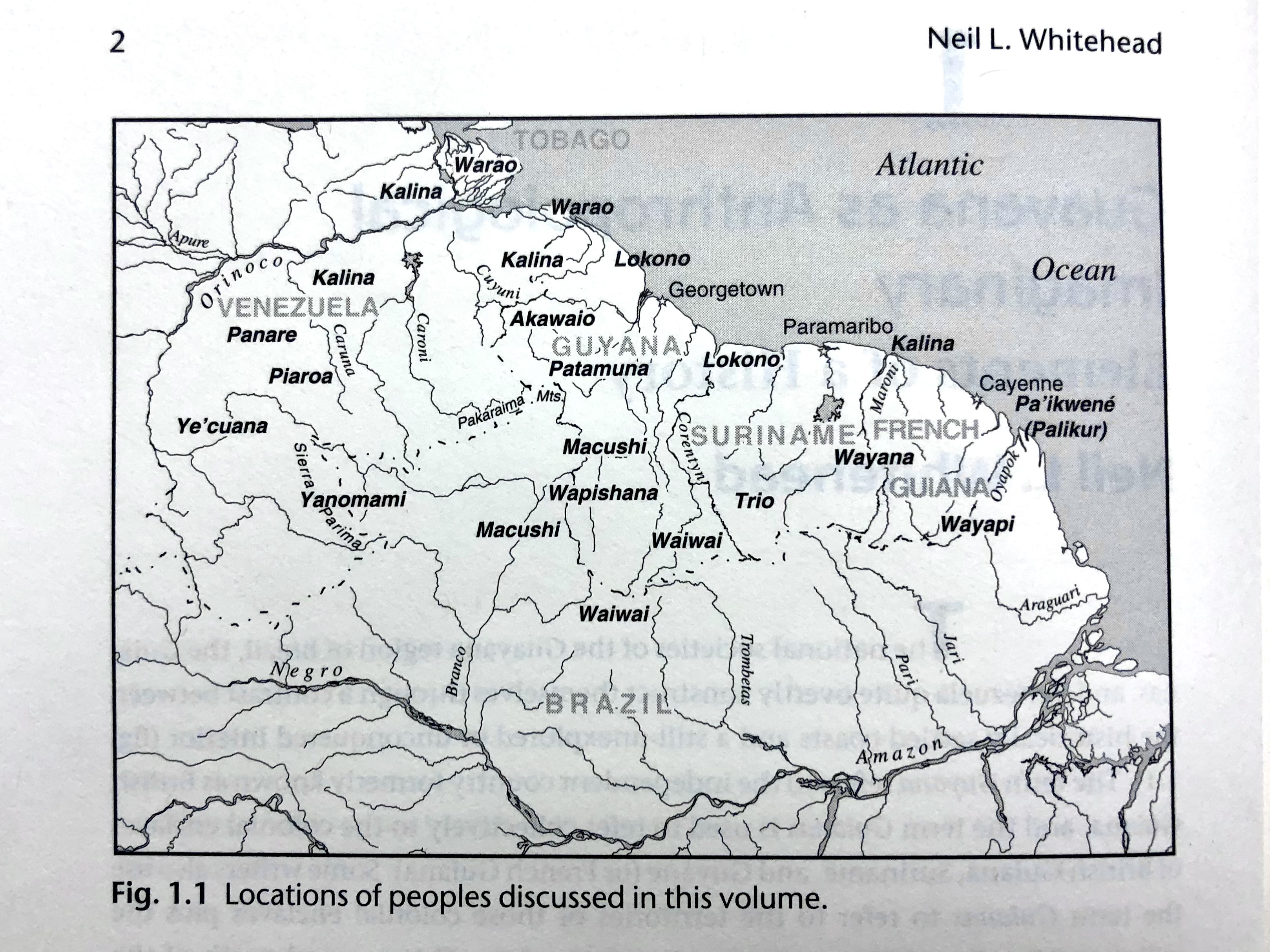
Dispossesions in the Americas

Dispossesions in the Americas

  • Home
  • Explore
  • About
  • Authors
  • Art
  • Bodies
  • Curricula
  • Cultural Heritage
  • Maps
  • Territories
Back to Explore
Map 1900 - 1999

Fig. 1.1 Locations of peoples discussed in this volume

  • Whitehead, Neil L.

Published: 2009

  • Download Image

Peoples

  • AKAWAIO
  • KALINA
  • LOKONO
  • MACUSHI
  • PA'IKWENE
  • PALIKUR
  • PANARE
  • PATAMUNA
  • PIAROA
  • TRIO
  • WAIWAI
  • WAPISHANA
  • WARAO
  • WAYANA
  • WAYAPI
  • YANOMAMI
  • YE'CUANA

Citation

Neil L. Whitehead, and Stephanie W. Alemán (eds.), Anthropologies of Guayana: Cultural Spaces in Northeastern Amazonia. (Tucson: University of Arizona Press, 2009), 2.

  • Download Image

Reading in Spanish

Map 1900 - 1999

Fig. 1.1 Locations of peoples discussed in this volume

  • Whitehead, Neil L.

Published: 2009

  • Download Image
  • Download Image

Reading in Portuguese

Map 1900 - 1999

Fig. 1.1 Locations of peoples discussed in this volume

  • Whitehead, Neil L.

Published: 2009

  • Download Image

Peoples

  • AKAWAIO
  • KALINA
  • LOKONO
  • MACUSHI
  • PA'IKWENE
  • PALIKUR
  • PANARE
  • PATAMUNA
  • PIAROA
  • TRIO
  • WAIWAI
  • WAPISHANA
  • WARAO
  • WAYANA
  • WAYAPI
  • YANOMAMI
  • YE'CUANA

Citation

Neil L. Whitehead, and Stephanie W. Alemán (eds.), Anthropologies of Guayana: Cultural Spaces in Northeastern Amazonia. (Tucson: University of Arizona Press, 2009), 2.

  • Download Image

Related Content

Territory of the Jumanos, Mansos, and Sumas

Territory of the Jumanos, Mansos, and Sumas

Map 1997
Kowkülen [Liquid being]

Kowkülen [Liquid being]

Artwork
Peru

Peru

Map 1630
MAP OF NEW GRANADA

MAP OF NEW GRANADA

Map 1864
A New Map of Mexico and Adjacent Provinces Compiled From Original Documents

A New Map of Mexico and Adjacent Provinces Compiled From Original Documents

Map 1810
‘INDIAN ROYAL TOWNS’ (REDUCCIONES) IN THE PACAJES PROVINCE (CORREGIMIENTO) UNDER SPANISH COLONIAL RULE IN THE LATE 16TH CENTURY

‘INDIAN ROYAL TOWNS’ (REDUCCIONES) IN THE PACAJES PROVINCE (CORREGIMIENTO) UNDER SPANISH COLONIAL RULE IN THE LATE 16TH CENTURY

Map 1570 - 1630
IDIOMAS DE GUATEMALA Y BELICE

IDIOMAS DE GUATEMALA Y BELICE

Map
Principales poblados de la Verapaz y localización de los idomas d ela zona, siglo XVI.

Principales poblados de la Verapaz y localización de los idomas d ela zona, siglo XVI.

Map 1600

Dispossessions in the Americas

A project by

University of Pennsylvania

Copyright 2024

With support from

Mellon Foundation

Site design & development

Element 84

Art Credits

Neil L. Whitehead, and Stephanie W. Alemán (eds.), Anthropologies of Guayana: Cultural Spaces in Northeastern Amazonia. (Tucson: University of Arizona Press, 2009), 2.

Site Pages

  • Home
  • Explore
  • About
  • Authors
  • Art
  • Bodies
  • Curricula
  • Cultural Heritage
  • Maps
  • Territories