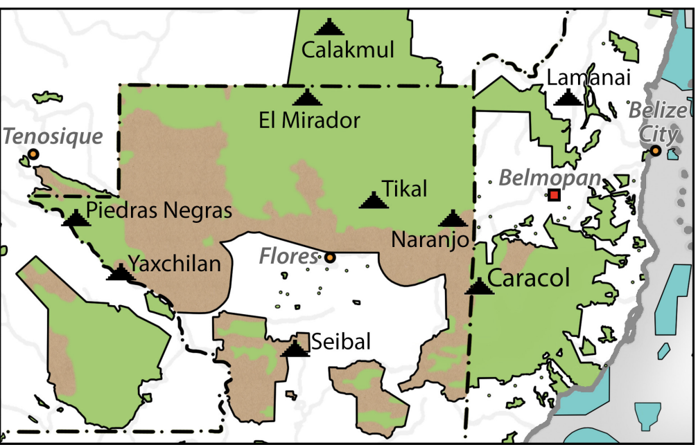
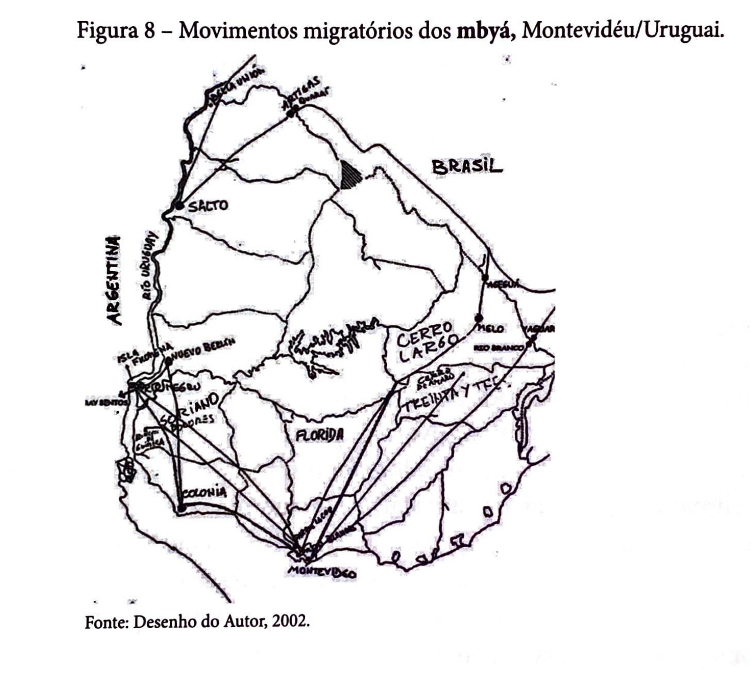
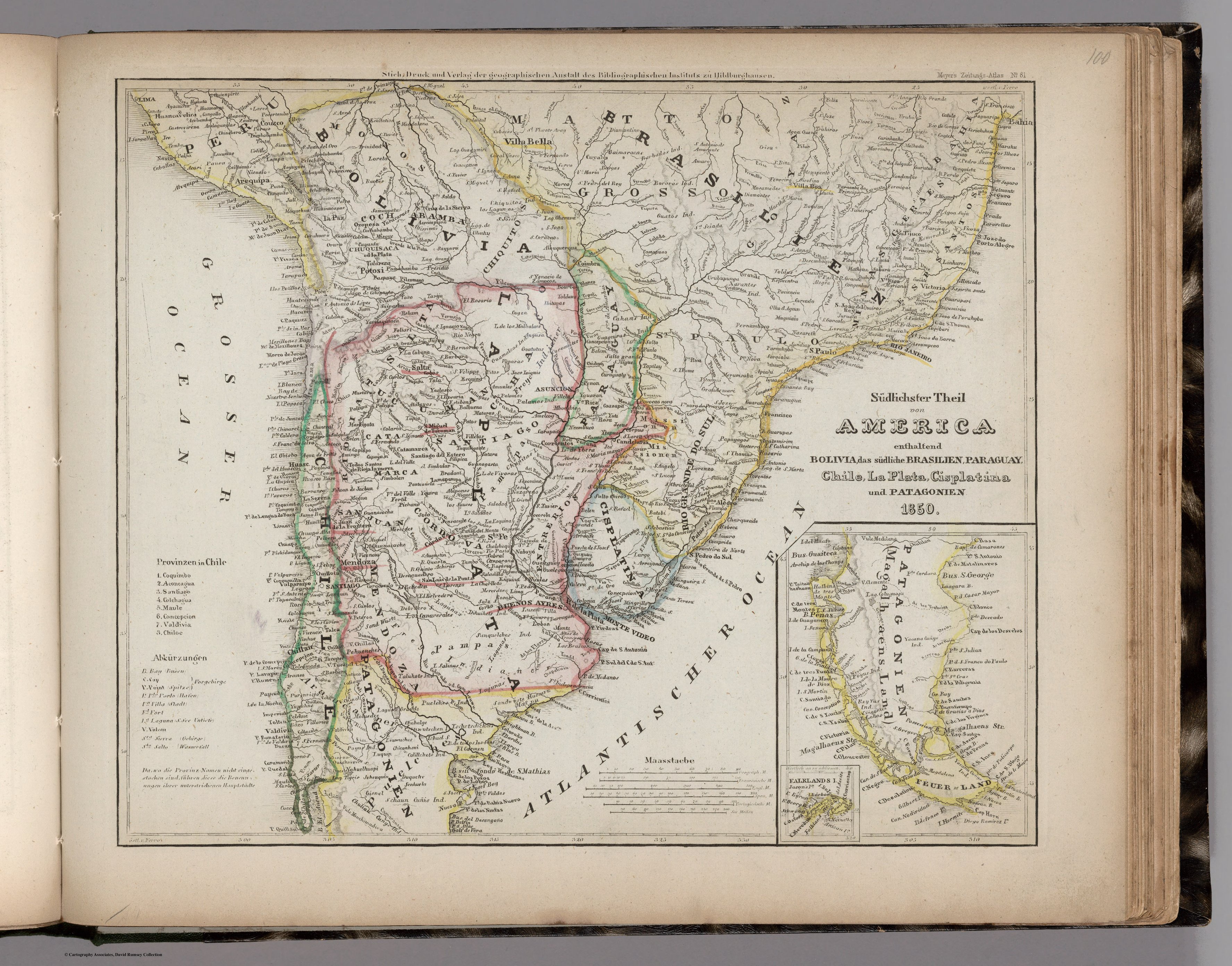
Dispossesions in the Americas

Dispossesions in the Americas

  • Home
  • Explore
  • About
  • Authors
  • Art
  • Bodies
  • Curricula
  • Cultural Heritage
  • Maps
  • Territories
Back to Explore
Map 1850

Sudlichster Theil von AMERICA enthaltend BOLIVIA, das sudliche BRASILIEN, PARAGUAY, Chile, La Plata, Cisplatina und PATAGONIEN

  • MEYER, JOSEPH

Published: 1850

  • Download Image

Peoples

  • GUATOS
  • BORBROS
  • BARBADOS
  • XAVANTES
  • CHIQUITOS
  • YURACARAES
  • CAHANS
  • GUAYCURUS
  • COROMETES
  • GUAMALCAS
  • PALAMOS
  • CHUPITAS
  • PICUNTSCHEN
  • DIHUIHETS
  • TALUHETS
  • PUCLCHES
  • TSCHETSCHCHETS
  • CALILLCHETS
  • POYUS
  • SCHAUN CUNIS
  • CHULIAU-CUNYS
  • GUATUTAS
  • VAPARAS
  • MBOCOBIS

Citation

Meyer, Joseph. Sudlichster Theil von America enthaltend Bolivia, das sudliche Brasilien, Paraguay, Chile, La Plata, Cisplatina und Patagonien. Map. Hildburghausen: Bibliographischen Instituts, 1850. Accessed August 13, 2023. https://www.davidrumsey.com/luna/servlet/detail/RUMSEY~8~1~305111~90075536.

  • Download Image

Reading in Spanish

Map 1850

Sudlichster Theil von AMERICA enthaltend BOLIVIA, das sudliche BRASILIEN, PARAGUAY, Chile, La Plata, Cisplatina und PATAGONIEN

  • MEYER, JOSEPH

Published: 1850

  • Download Image
  • Download Image

Related Content

Map of deforestation within protected areas in Guatemala and adjoining areas

Map of deforestation within protected areas in Guatemala and adjoining areas

Map 2000 - 2100
Movimentos migratórios dos mbyá, Montevidéu/Uruguai

Movimentos migratórios dos mbyá, Montevidéu/Uruguai

Map 1980
REGIÓN HUICOT O GRAN NAYAR

REGIÓN HUICOT O GRAN NAYAR

Map 2000
PUEBLO CHONTAL DE OAXACA

PUEBLO CHONTAL DE OAXACA

Map 2020
PUEBLO MIXTECO

PUEBLO MIXTECO

Map 2020
The Yuman Ethnolinguistic Family

The Yuman Ethnolinguistic Family

Map 2016
Comunidad "Territorio Indígena General E. Mosconi Tres Paraísos" - Pueblo Wichí

Comunidad "Territorio Indígena General E. Mosconi Tres Paraísos" - Pueblo Wichí

Map 2020
"Carta Maritima del Reyno de Tierra Firme ú Castilla del Oro : Comprehende el Istmo y Provincia de Panamá, las Provincias de Veragua, Darien y Biruquete"

"Carta Maritima del Reyno de Tierra Firme ú Castilla del Oro : Comprehende el Istmo y Provincia de Panamá, las Provincias de Veragua, Darien y Biruquete"

Map 1729 - 1776

Dispossessions in the Americas

A project by

University of Pennsylvania

Copyright 2024

With support from

Mellon Foundation

Site design & development

Element 84

Art Credits

Meyer, Joseph. Sudlichster Theil von America enthaltend Bolivia, das sudliche Brasilien, Paraguay, Chile, La Plata, Cisplatina und Patagonien. Map. Hildburghausen: Bibliographischen Instituts, 1850. Accessed August 13, 2023. https://www.davidrumsey.com/luna/servlet/detail/RUMSEY~8~1~305111~90075536.

Site Pages

  • Home
  • Explore
  • About
  • Authors
  • Art
  • Bodies
  • Curricula
  • Cultural Heritage
  • Maps
  • Territories