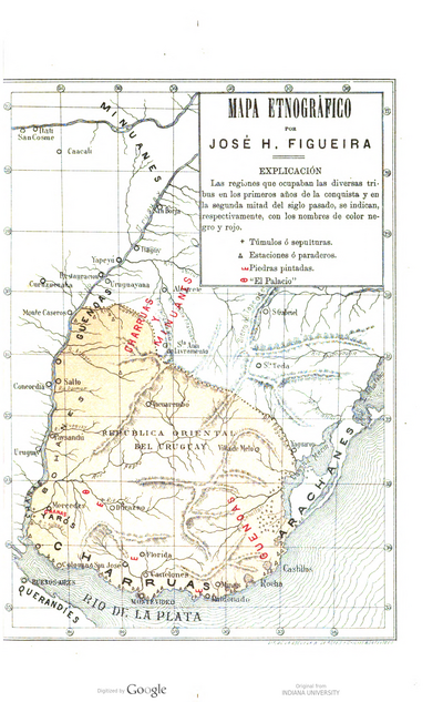
Dispossesions in the Americas

Dispossesions in the Americas

  • Home
  • Explore
  • About
  • Authors
  • Art
  • Bodies
  • Curricula
  • Cultural Heritage
  • Maps
  • Territories
Back to Explore
Map 1794

CHART containing the greater part of the SOUTH SEA to the South of the LINE, with the ISLANDS dispersed thro' the same

  • WHITTLE, JAMES

Published: 1794

  • Download Image

Peoples

  • TUPINAMBAS
  • TAPUYAS
  • CHIQUITOS
  • GUAYCURUS
  • CHARUAS
  • PATAGOUS

Citation

Whittle, James, and Robert Laurie. Chart containing the greater part of the South Sea to the South of the Line, with the Islands dispersed thro' the same. Map. London: Laurie & Whittle, 1794. Accessed August 13, 2023. https://gallica.bnf.fr/ark:/12148/btv1b53123130r/f1.item.

  • Download Image

Reading in Spanish

Map 1794

CHART containing the greater part of the SOUTH SEA to the South of the LINE, with the ISLANDS dispersed thro' the same

  • WHITTLE, JAMES

Published: 1794

  • Download Image
  • Download Image

Related Content

PUEBLO AIMARA

PUEBLO AIMARA

Map 2021
Provincias de Cumana;Paria;la Isla de la Trinidad;y el Rio Orinoco. 1758.

Provincias de Cumana;Paria;la Isla de la Trinidad;y el Rio Orinoco. 1758.

Map 1758
PUEBLO NAHUA DE PUEBLA

PUEBLO NAHUA DE PUEBLA

Map 2020
MAPA de las PROVINCIAS DE VENEZUELA Y DEL REINO DE SANTA FE

MAPA de las PROVINCIAS DE VENEZUELA Y DEL REINO DE SANTA FE

Map 1831
Asentamientos de los Pipiles-Nicaraos

Asentamientos de los Pipiles-Nicaraos

Map 1972
FACSIMILE: PART OF AMERICA BY GUSSEFELDT

FACSIMILE: PART OF AMERICA BY GUSSEFELDT

Map 1796
Centroamérica: localización de algunos componentes culturales. 1950-1955

Centroamérica: localización de algunos componentes culturales. 1950-1955

Map 1950
Mapa de El Salvador señalando los asentamientos indígenas del país. Fuente: Tierras Nativas. Proyecto de Actualización del Mapa
“Co-Existencia de los Pueblos Indígenas y el Ambiente Natural de Centro América”. (CONCULTURA 2003)

Mapa de El Salvador señalando los asentamientos indígenas del país. Fuente: Tierras Nativas. Proyecto de Actualización del Mapa “Co-Existencia de los Pueblos Indígenas y el Ambiente Natural de Centro América”. (CONCULTURA 2003)

Map 2003

Dispossessions in the Americas

A project by

University of Pennsylvania

Copyright 2024

With support from

Mellon Foundation

Site design & development

Element 84

Art Credits

Whittle, James, and Robert Laurie. Chart containing the greater part of the South Sea to the South of the Line, with the Islands dispersed thro’ the same. Map. London: Laurie & Whittle, 1794. Accessed August 13, 2023. https://gallica.bnf.fr/ark:/12148/btv1b53123130r/f1.item.

Site Pages

  • Home
  • Explore
  • About
  • Authors
  • Art
  • Bodies
  • Curricula
  • Cultural Heritage
  • Maps
  • Territories