Dispossesions in the Americas

Dispossesions in the Americas

  • Home
  • Explore
  • About
  • Authors
  • Art
  • Bodies
  • Curricula
  • Cultural Heritage
  • Maps
  • Territories
Back to Explore
Map 1800 - 1899

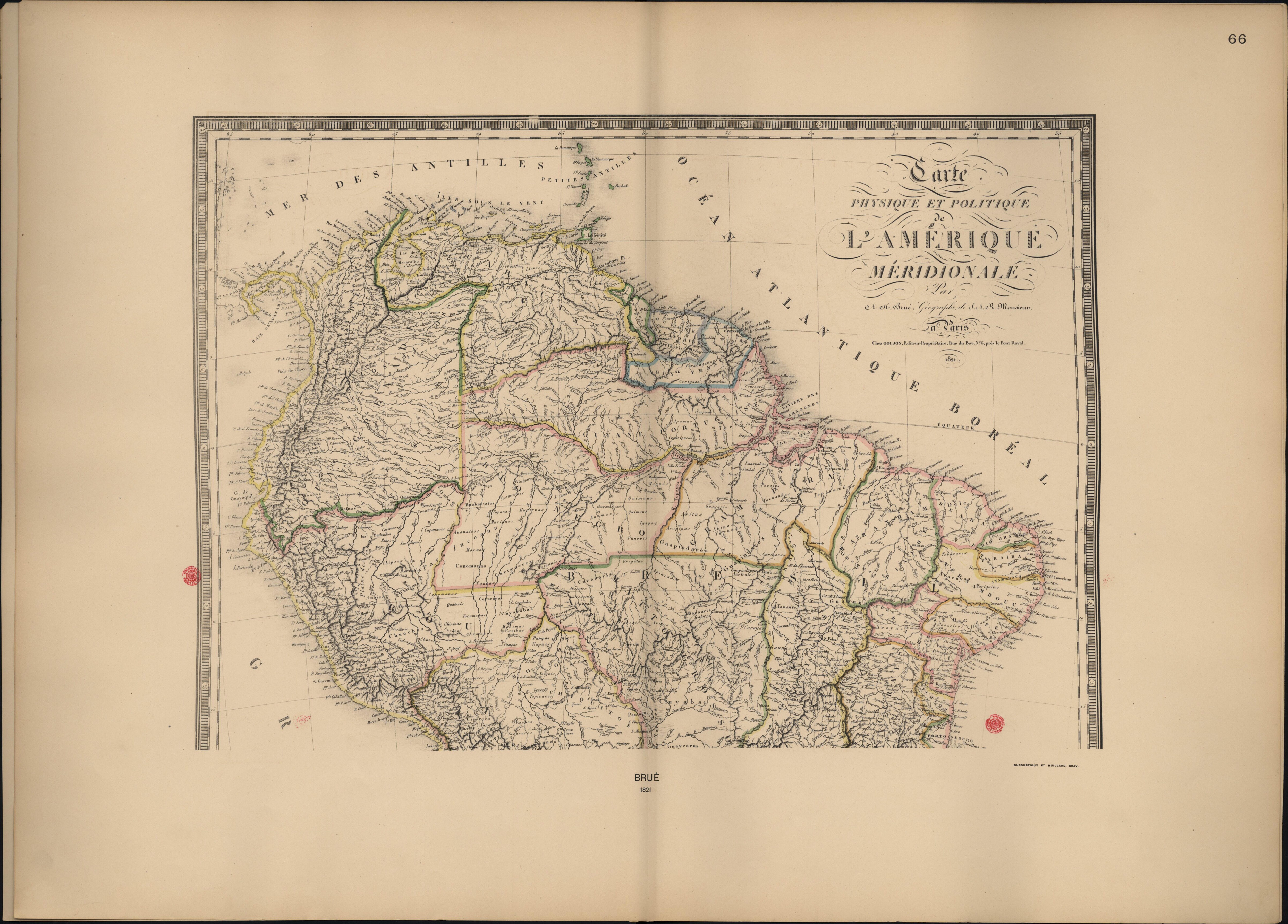
Carte Physique et Politique de l'Amérique Méridionale.

  • Brué, A. H.

Published: 1821

  • Download Image

Peoples

  • ABACATES
  • ACOQUAS
  • ACRIAS
  • ANAMARIS
  • APAMAS
  • APERAS
  • APIACAS
  • ARACUYAS
  • ARAMICHAUX
  • ARAPIYUS
  • ARAYAS
  • ARINOS
  • ARITUS
  • ARUACAS
  • AUANATEOS
  • BACAURIS
  • BARBADOS
  • BARBUDOS
  • BAURES
  • BOROROS
  • CACIGARAS
  • CALCAYALARES
  • CALEXIS
  • CAMAYARIS
  • CAMIANAS
  • CAPANAXAS
  • CARANGUES
  • CARAYAS
  • CARIGUAN
  • CARPINAS
  • CHIPEOS
  • CHIQUITOS
  • CHIRENES CHIRIVAS
  • CHUNCHOS
  • CICACICA
  • CONOMANAS
  • COPARIPUCUS
  • CORIAUNAS
  • CORUMBARES
  • COUSSARIS
  • CUACANAYAS
  • CURANARIS
  • CURIVARAS
  • CURIGUERES
  • CURUCURUZ
  • CUYUBABAS
  • ENGAYABAS
  • GALIBIS
  • GUACURUACUAS
  • GUAPINDAYES
  • GUAPINDAYES AUSTRALES
  • GUARANACACOS
  • GUARINOMAS
  • GUAYAPIS
  • GUAYAZAS
  • GUAYCORUS
  • GUEGUES
  • GUVAYES
  • HUAHUATATES
  • HUAIRVAS
  • IGAPOY
  • JOAZEIROS
  • KIRIKIRIS
  • MACUSIS
  • MAGUES
  • MAMAYANAGES
  • MARIOUES
  • MARIQUITOS
  • MAYEZ
  • MOCHOBOS
  • MORUAS
  • MOTUANIS
  • MOXOS
  • NAUNAS
  • OBACATIARAS
  • OMAGUAS
  • OREGATUS
  • PACAJAS
  • PARABAYANAS
  • PALICOURS
  • PETIGUARES
  • PUNOVIS
  • QUATOSIS
  • QUIMAUS
  • RACHES
  • SAMACHUANOS
  • TACUANHAS
  • TAPICURES
  • TAPIRAPEQUES
  • TIGUARES
  • TOBAXARES
  • TOPINAMBAS
  • TOROMOMAS
  • TUERE
  • XAVANTES
  • YOEMANAIS
  • YUCARES
  • YUNGAS
  • YURUNAS
  • ZURINAS

Citation

Brué, A. H., Atlas accompagnant le premier mémoire du Brésil. Biblioteca Nacional Digital. Accessed, August 5, 2023. bndigital.bnportugal.gov.pt/idviewer/14413/106 bndigital.bnportugal.gov.pt/idviewer/14413/106
  • Download Image

Reading in Spanish

Map 1800 - 1899

Carte Physique et Politique de l'Amérique Méridionale.

  • Brué, A. H.

Published: 1821

  • Download Image
  • Download Image

Related Content

Guide map of the tribes and subjects of Volume 1 of the Handbook

Guide map of the tribes and subjects of Volume 1 of the Handbook

Map
Der Nordliche Theil von Sud-America

Der Nordliche Theil von Sud-America

Map 1800 - 1899
Radicación de Comunidades Mapuche. Titulos de Comisario y Titulos de Merced

Radicación de Comunidades Mapuche. Titulos de Comisario y Titulos de Merced

Map 1884 - 1929
PARAGUAY

PARAGUAY

Map 1878
Map of the RIVER AQUIRY (an Affluent of the Purûs)

Map of the RIVER AQUIRY (an Affluent of the Purûs)

Map 1800 - 1850
Isle Ste. Catherine

Isle Ste. Catherine

Map 1650 - 1750
The indigenous language groups  of Baja California at contact

The indigenous language groups of Baja California at contact

Map 1530
MAPA DE LA NUEVA PROVINCIA POBLADA DE BARBAROS, SITUADA EN LA COSTA DEL SENO MEXICANO, DESDE EL PUERTO DE TAMPICO HASTA LA PROVINCIA DE TEXAS

MAPA DE LA NUEVA PROVINCIA POBLADA DE BARBAROS, SITUADA EN LA COSTA DEL SENO MEXICANO, DESDE EL PUERTO DE TAMPICO HASTA LA PROVINCIA DE TEXAS

Map 1744

Dispossessions in the Americas

A project by

University of Pennsylvania

Copyright 2024

With support from

Mellon Foundation

Site design & development

Element 84

Art Credits

Brué, A. H., Atlas accompagnant le premier mémoire du Brésil. Biblioteca Nacional Digital. Accessed, August 5, 2023. bndigital.bnportugal.gov.pt/idviewer/14413/106 bndigital.bnportugal.gov.pt/idviewer/14413/106
Site Pages

  • Home
  • Explore
  • About
  • Authors
  • Art
  • Bodies
  • Curricula
  • Cultural Heritage
  • Maps
  • Territories