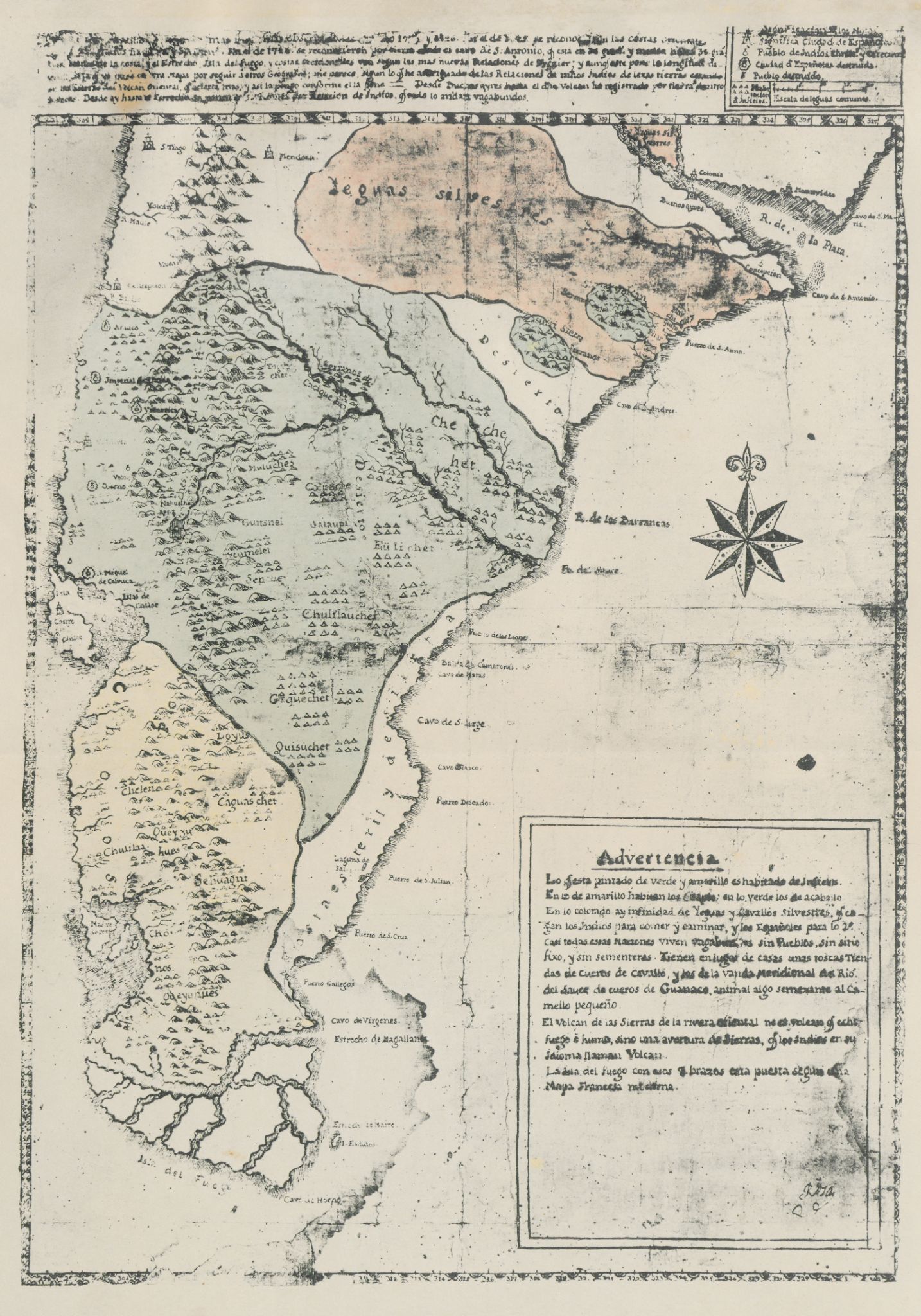
Dispossesions in the Americas

Dispossesions in the Americas

  • Home
  • Explore
  • About
  • Authors
  • Art
  • Bodies
  • Curricula
  • Cultural Heritage
  • Maps
  • Territories
Back to Explore
Map 1700 - 1750

Carta inédita de la extremidad austral de América construída por el P. José Cardiel, S. J. en 1747

  • CARDIEL, JOSE

Published: 1747

  • Download Image

Peoples

  • POBLACION INFIEL
  • CHE CHE HET
  • EULICHET
  • UAIAUPI
  • TUCUMELEL
  • CHULILAUCHES
  • GEQUECHET
  • QUISUCHER
  • LOYUS
  • CHELEN
  • CHULILA
  • QUEYJU
  • SEHUAGNI
  • QUEYUANES

Citation

Cardiel, Jose, and Guillermo Furlong. Carta inédita de la extremidad austral de América construída por el P. José Cardiel, S. J. en 1747. Map. Buenos Aires, Argentina, 1747. Accessed July 9, 2023. https://digital.iai.spk-berlin.de/viewer/image/630121893/1/LOG_0000/.

  • Download Image

Reading in Spanish

Map 1700 - 1750

Carta inédita de la extremidad austral de América construída por el P. José Cardiel, S. J. en 1747

  • CARDIEL, JOSE

Published: 1747

  • Download Image
  • Download Image

Reading in Portuguese

Map 1700 - 1750

Carta inédita de la extremidad austral de América construída por el P. José Cardiel, S. J. en 1747

  • CARDIEL, JOSE

Published: 1747

  • Download Image

Peoples

  • POBLACION INFIEL
  • CHE CHE HET
  • EULICHET
  • UAIAUPI
  • TUCUMELEL
  • CHULILAUCHES
  • GEQUECHET
  • QUISUCHER
  • LOYUS
  • CHELEN
  • CHULILA
  • QUEYJU
  • SEHUAGNI
  • QUEYUANES

Citation

Cardiel, Jose, and Guillermo Furlong. Carta inédita de la extremidad austral de América construída por el P. José Cardiel, S. J. en 1747. Map. Buenos Aires, Argentina, 1747. Accessed July 9, 2023. https://digital.iai.spk-berlin.de/viewer/image/630121893/1/LOG_0000/.

  • Download Image

Related Content

PARAGUAY Language Families

PARAGUAY Language Families

Map
Popoloca Towns

Popoloca Towns

Map 1950
El lugar de los espíritus [The Place of the Spirits]

El lugar de los espíritus [The Place of the Spirits]

Artwork
Le Perou dans l'Amerique Meridionale Dresse sur les divers relations des filibustiers et nouveaux voyageurs

Le Perou dans l'Amerique Meridionale Dresse sur les divers relations des filibustiers et nouveaux voyageurs

Map 1719
Los a'i como área cultural chibcha

Los a'i como área cultural chibcha

Map 1997
Terre de Sainte Croix, nommée apresent Bresil

Terre de Sainte Croix, nommée apresent Bresil

Map 1749
Ubicación geográfica del pueblo texistepequeño

Ubicación geográfica del pueblo texistepequeño

Map 2018
Carte de la Partie Orientale de la Province de Varinas comprise entre L'Orenoque;L'Apure et le Rio Meta

Carte de la Partie Orientale de la Province de Varinas comprise entre L'Orenoque;L'Apure et le Rio Meta

Map 1800

Dispossessions in the Americas

A project by

University of Pennsylvania

Copyright 2024

With support from

Mellon Foundation

Site design & development

Element 84

Art Credits

Cardiel, Jose, and Guillermo Furlong. Carta inédita de la extremidad austral de América construída por el P. José Cardiel, S. J. en 1747. Map. Buenos Aires, Argentina, 1747. Accessed July 9, 2023. https://digital.iai.spk-berlin.de/viewer/image/630121893/1/LOG_0000/.

Site Pages

  • Home
  • Explore
  • About
  • Authors
  • Art
  • Bodies
  • Curricula
  • Cultural Heritage
  • Maps
  • Territories