Dispossesions in the Americas

Dispossesions in the Americas

  • Home
  • Explore
  • About
  • Authors
  • Art
  • Bodies
  • Curricula
  • Cultural Heritage
  • Maps
  • Territories
Back to Explore
Map 1800 - 1850

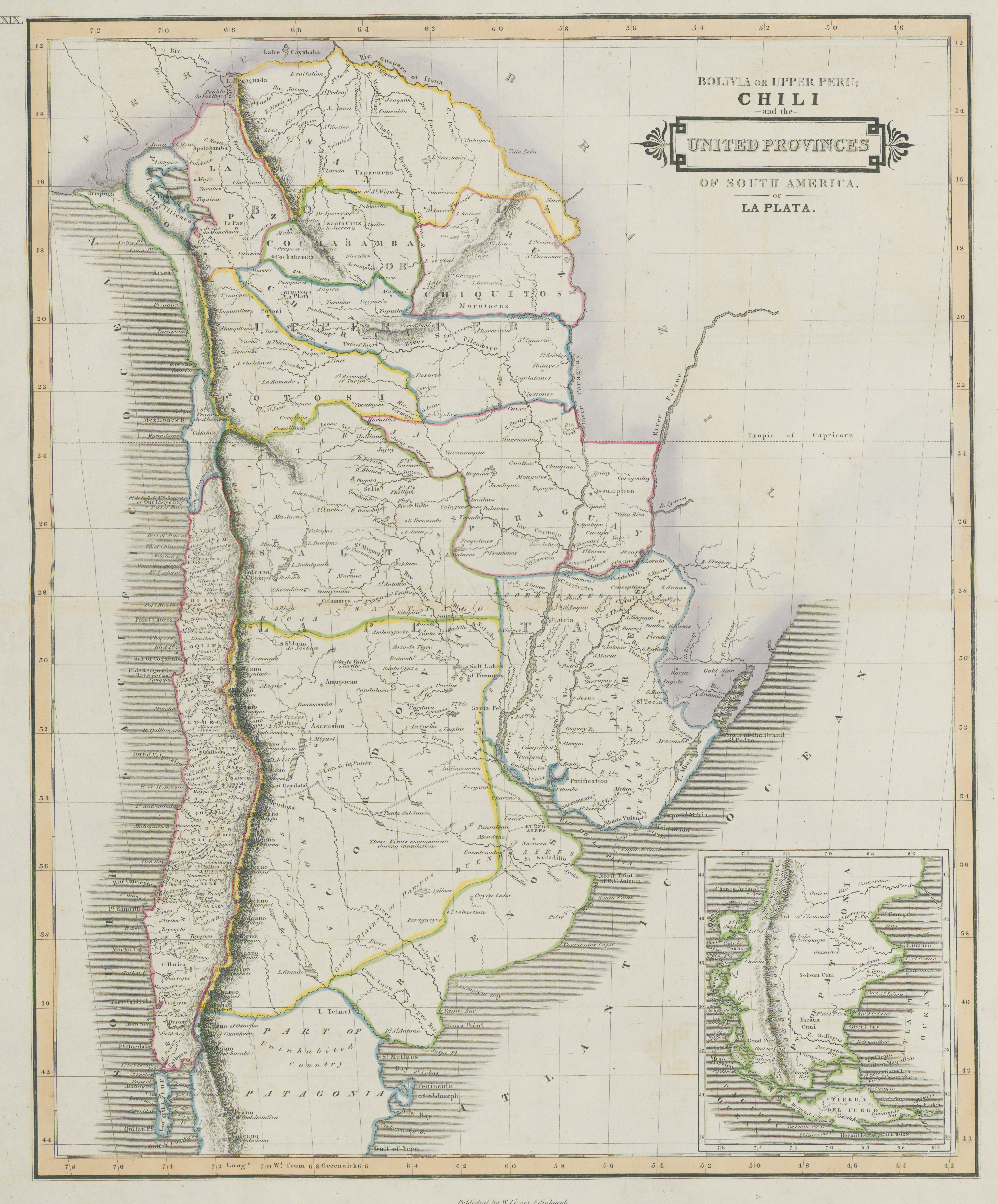
Bolivia Or Upper Peru;Chili and the United Provinces Of South America, or La Plata

  • LIZARS, WILLIAM

Published: 1836

  • Download Image

Peoples

  • PEHUENCHES
  • TAPICURAS
  • MOROROCOS
  • YACANA CUNI

Citation

Lizars, William. Bolivia Or Upper Peru, Chili and the United Provinces Of South America, or La Plata. Map. Edimburgh, Scotland: W. Lizars, 1836. Accessed July 9, 2023. https://digital.iai.spk-berlin.de/viewer/image/630121303/1/LOG_0000/.
  • Download Image

Reading in Spanish

Map 1800 - 1850

Bolivia Or Upper Peru;Chili and the United Provinces Of South America, or La Plata

  • LIZARS, WILLIAM

Published: 1836

  • Download Image
  • Download Image

Related Content

CARTA GEOGRÁFICA DEL ECUADOR POR DR. TEODORO WOLF;PUBLICADA POR ORDEN DEL SUPREMO GOBIERNO DE LA REPÚBLICA Y TRABAJADA BAJO LAS PRESIDENCIAS DE LOS EE. SEÑORES DR. D.J.M. PLÁCIDO CAAMAÑO Y DR. D. ANTONIO FLORES. 1892 ... INSTITUTO GEOGRAFICO DE H. WAGNER & E. DEBES EN LEIPZIG. (WITH) LA REGION ORIENTAL DEL ECUADOR. (WITH) ARCHIPIÉLAGO DE GALÁPAGOS.

CARTA GEOGRÁFICA DEL ECUADOR POR DR. TEODORO WOLF;PUBLICADA POR ORDEN DEL SUPREMO GOBIERNO DE LA REPÚBLICA Y TRABAJADA BAJO LAS PRESIDENCIAS DE LOS EE. SEÑORES DR. D.J.M. PLÁCIDO CAAMAÑO Y DR. D. ANTONIO FLORES. 1892 ... INSTITUTO GEOGRAFICO DE H. WAGNER & E. DEBES EN LEIPZIG. (WITH) LA REGION ORIENTAL DEL ECUADOR. (WITH) ARCHIPIÉLAGO DE GALÁPAGOS.

Map 1892
Pueblos Indígenas y Ecosistemas Naturales en Centroamérica y el Sur de México

Pueblos Indígenas y Ecosistemas Naturales en Centroamérica y el Sur de México

Map 2000 - 2024
Pueblo y tierras de Sopó

Pueblo y tierras de Sopó

Map 1758
PUEBLO NAHUA DE SAN LUIS POTOSI

PUEBLO NAHUA DE SAN LUIS POTOSI

Map 2020
Mappa da actual distribuição dos indios no Brazil meridional

Mappa da actual distribuição dos indios no Brazil meridional

Map 1857 - 1907
Tequistlatec and Tlapanec Areas, Mexico

Tequistlatec and Tlapanec Areas, Mexico

Map 1915
REGIÓN OTOMI DE HIDALGO Y QUERETARO

REGIÓN OTOMI DE HIDALGO Y QUERETARO

Map 2000
Carte de la cote orientale Du Brésil entre le 15e et le 23e degré de latitude australe

Carte de la cote orientale Du Brésil entre le 15e et le 23e degré de latitude australe

Map 1821

Dispossessions in the Americas

A project by

University of Pennsylvania

Copyright 2024

With support from

Mellon Foundation

Site design & development

Element 84

Art Credits

Lizars, William. Bolivia Or Upper Peru, Chili and the United Provinces Of South America, or La Plata. Map. Edimburgh, Scotland: W. Lizars, 1836. Accessed July 9, 2023. https://digital.iai.spk-berlin.de/viewer/image/630121303/1/LOG_0000/.
Site Pages

  • Home
  • Explore
  • About
  • Authors
  • Art
  • Bodies
  • Curricula
  • Cultural Heritage
  • Maps
  • Territories