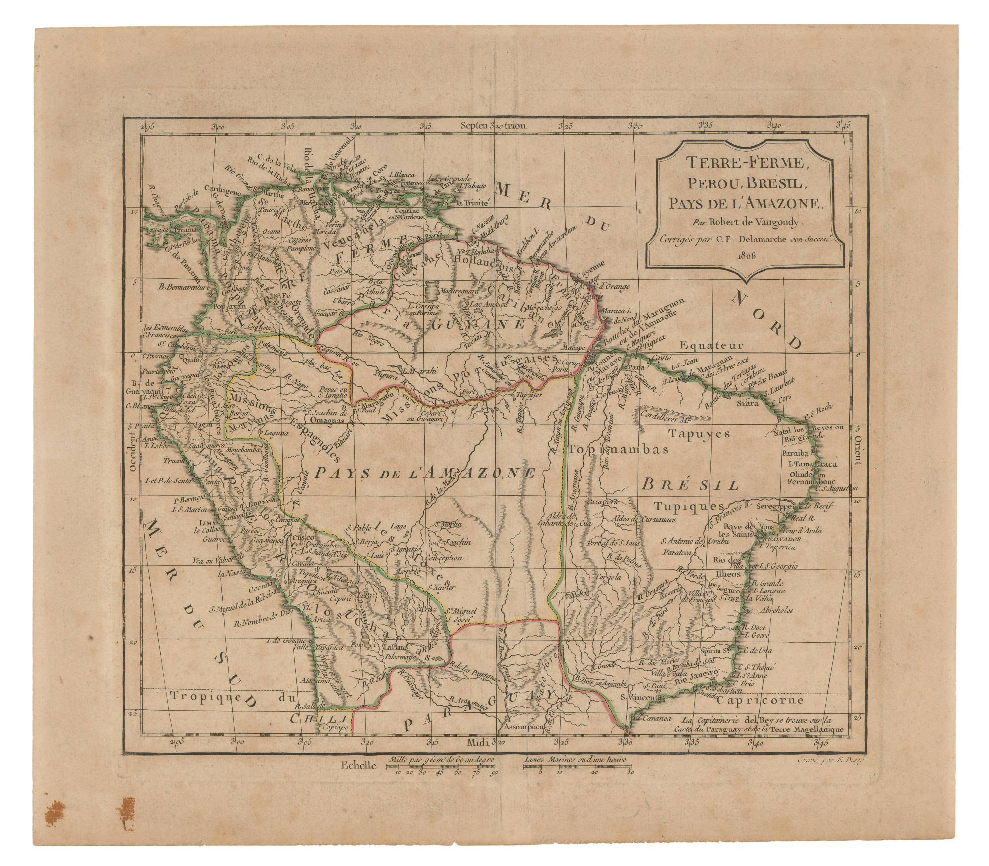
Dispossesions in the Americas

Dispossesions in the Americas

  • Home
  • Explore
  • About
  • Authors
  • Art
  • Bodies
  • Curricula
  • Cultural Heritage
  • Maps
  • Territories
Back to Explore
Map 1806

TERRE-FERME, PEROU, BRESIL, PAYS DE L'AMAZONE

  • DE VAUGONDY, ROBERT, ET AL.

Published: 1806

  • Download Image

Peoples

  • CARIBANE
  • QUIXOS
  • PACAMORES
  • MAYNAS
  • OMAGUAS
  • TAPUYES
  • TOPINAMBAS
  • MOXES
  • TUPIQUES

Citation

de Vaugondy, Robert, and Charles Francois Delamarche. "Terre-Ferme, Perou, Bresil, Pays de L'Amazone." Map. 1806. Accessed July 6, 2023. https://babel.banrepcultural.org/digital/collection/p17054coll13/id/415/rec/8.

  • Download Image

Reading in Spanish

Map 1806

TERRE-FERME, PEROU, BRESIL, PAYS DE L'AMAZONE

  • DE VAUGONDY, ROBERT, ET AL.

Published: 1806

  • Download Image
  • Download Image

Reading in Portuguese

Map 1806

TERRE-FERME, PEROU, BRESIL, PAYS DE L'AMAZONE

  • DE VAUGONDY, ROBERT, ET AL.

Published: 1806

  • Download Image

Peoples

  • CARIBANE
  • QUIXOS
  • PACAMORES
  • MAYNAS
  • OMAGUAS
  • TAPUYES
  • TOPINAMBAS
  • MOXES
  • TUPIQUES

Citation

de Vaugondy, Robert, and Charles Francois Delamarche. "Terre-Ferme, Perou, Bresil, Pays de L'Amazone." Map. 1806. Accessed July 6, 2023. https://babel.banrepcultural.org/digital/collection/p17054coll13/id/415/rec/8.

  • Download Image

Related Content

VENEZUELA

VENEZUELA

Map 1878
A la France Partie de la Guyane

A la France Partie de la Guyane

Map 1732
Chile's Indigenous Population

Chile's Indigenous Population

Map 2021
Map of Coatlinchan (Valley of Mexico), 1584, Archivo General de la Nación no. 566

Map of Coatlinchan (Valley of Mexico), 1584, Archivo General de la Nación no. 566

Map 1584
Official Map of Nicaragua.

Official Map of Nicaragua.

Map 1898
Carte géographo-géologique de la Guyane Française Dressée sur les relevés de Mr. Leblond, Médecin Naturaliste Pentionné de S.M. Louis XVI

Carte géographo-géologique de la Guyane Française Dressée sur les relevés de Mr. Leblond, Médecin Naturaliste Pentionné de S.M. Louis XVI

Map 1814
The Aboriginal Distribution of Tribes in Northwest Mexico

The Aboriginal Distribution of Tribes in Northwest Mexico

Map 1969
Caminho do Kechuita, Aguapé, RS/Brasil

Caminho do Kechuita, Aguapé, RS/Brasil

Map 1999

Dispossessions in the Americas

A project by

University of Pennsylvania

Copyright 2024

With support from

Mellon Foundation

Site design & development

Element 84

Art Credits

de Vaugondy, Robert, and Charles Francois Delamarche. “Terre-Ferme, Perou, Bresil, Pays de L’Amazone.” Map. 1806. Accessed July 6, 2023. https://babel.banrepcultural.org/digital/collection/p17054coll13/id/415/rec/8.

Site Pages

  • Home
  • Explore
  • About
  • Authors
  • Art
  • Bodies
  • Curricula
  • Cultural Heritage
  • Maps
  • Territories