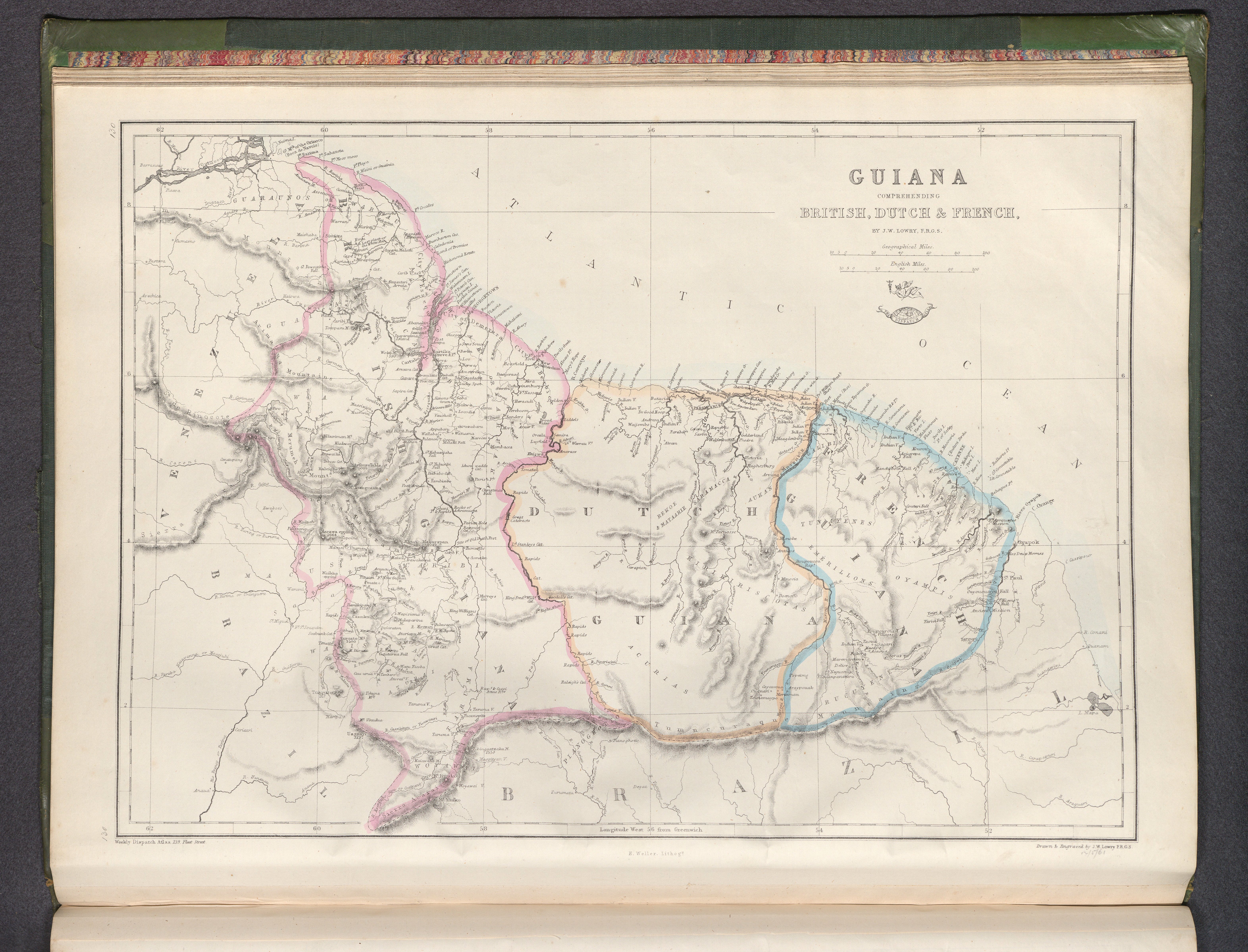
Dispossesions in the Americas

Dispossesions in the Americas

  • Home
  • Explore
  • About
  • Authors
  • Art
  • Bodies
  • Curricula
  • Cultural Heritage
  • Maps
  • Territories
Back to Explore
Map 1800 - 1899

Guiana, comprehending British, Dutch & French

  • Lowry, Joseph Wilson,

Published: 1863

  • Download Image

Peoples

  • ACURIAS
  • AUKAN
  • ARUAKA
  • ATOBAI
  • CARIBI
  • EMERILLONS
  • GALIBIS
  • GUAICA
  • GUARUNOS
  • KIRIKIRISCOTAS
  • MACUSI
  • OYAMPIS
  • PIANOGHOTTOWAICA
  • RUCUYENES
  • SARAMACCA
  • TUNAYENES
  • WAPISIANA
  • WARRAUWOYAWAI

Citation

Lowry, Joseph Wilson, Guiana, comprehending British, Dutch & French. David Rumsey Map Collection. Accessed: July 4, 2023. https://www.davidrumsey.com/luna/servlet/detail/RUMSEY~8~1~343750~90111648:Guiana,-comprehending-British,-Dutc

  • Download Image

Reading in Spanish

Map 1800 - 1899

Guiana, comprehending British, Dutch & French

  • Lowry, Joseph Wilson,

Published: 1863

  • Download Image
  • Download Image

Reading in Portuguese

Map 1800 - 1899

Guiana, comprehending British, Dutch & French

  • Lowry, Joseph Wilson,

Published: 1863

  • Download Image

Peoples

  • ACURIAS
  • AUKAN
  • ARUAKA
  • ATOBAI
  • CARIBI
  • EMERILLONS
  • GALIBIS
  • GUAICA
  • GUARUNOS
  • KIRIKIRISCOTAS
  • MACUSI
  • OYAMPIS
  • PIANOGHOTTOWAICA
  • RUCUYENES
  • SARAMACCA
  • TUNAYENES
  • WAPISIANA
  • WARRAUWOYAWAI

Citation

Lowry, Joseph Wilson, Guiana, comprehending British, Dutch & French. David Rumsey Map Collection. Accessed: July 4, 2023. https://www.davidrumsey.com/luna/servlet/detail/RUMSEY~8~1~343750~90111648:Guiana,-comprehending-British,-Dutc

  • Download Image

Related Content

PARAQVARIA vulgo PARAGVAY.

PARAQVARIA vulgo PARAGVAY.

Map 1600 - 1699
PUEBLO HUASTECO

PUEBLO HUASTECO

Map 2020
LE BRESIL

LE BRESIL

Map 1714
Plano geográfico de las provincias y terrenos confinantes a la Talamanca con demostración de su montañas, situaciones, etc.

Plano geográfico de las provincias y terrenos confinantes a la Talamanca con demostración de su montañas, situaciones, etc.

Map 1781
O Vendedor de frutas [The Fruit Vendor]

O Vendedor de frutas [The Fruit Vendor]

Artwork
Mapa de resguardos indígenas

Mapa de resguardos indígenas

Map 2012
Big Falls

Big Falls

Map 1997
MAPPA DO BRAZIL baseado no mappa da America do Sul de Stieler

MAPPA DO BRAZIL baseado no mappa da America do Sul de Stieler

Map 1900 - 1999

Dispossessions in the Americas

A project by

University of Pennsylvania

Copyright 2024

With support from

Mellon Foundation

Site design & development

Element 84

Art Credits

Lowry, Joseph Wilson, Guiana, comprehending British, Dutch & French. David Rumsey Map Collection. Accessed: July 4, 2023. https://www.davidrumsey.com/luna/servlet/detail/RUMSEY~8~1~343750~90111648:Guiana,-comprehending-British,-Dutc

Site Pages

  • Home
  • Explore
  • About
  • Authors
  • Art
  • Bodies
  • Curricula
  • Cultural Heritage
  • Maps
  • Territories