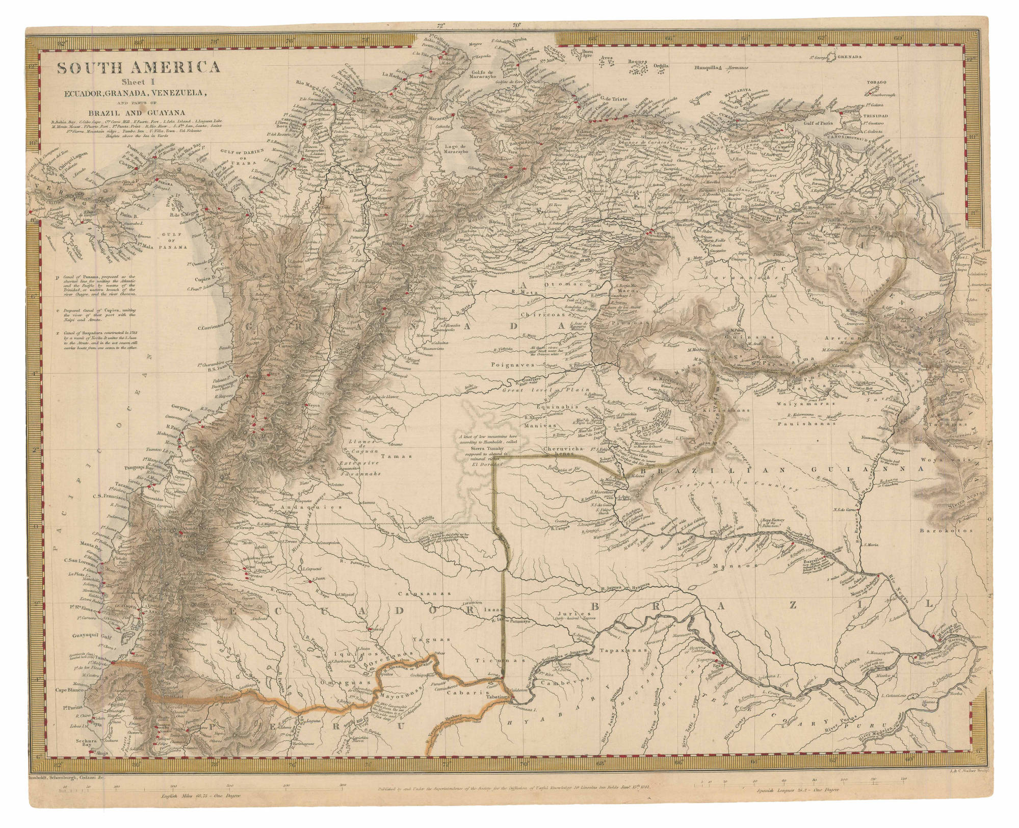
Dispossesions in the Americas

Dispossesions in the Americas

  • Home
  • Explore
  • About
  • Authors
  • Art
  • Bodies
  • Curricula
  • Cultural Heritage
  • Maps
  • Territories
Back to Explore
Map 1842

SOUTH AMERICA Sheet I: ECUADOR;GRANADA;VENEZUELA;AND PARTS OF BRAZIL AND GUYANA

  • HUMBOLDT;ALEXANDER;ET AL.

Published: 1842

  • Download Image

Peoples

  • GUARUANA
  • CARIBE
  • MACOS
  • OTOMACO
  • PUINAVE
  • CHIRICOA
  • PIAROA
  • MAIONGEONG
  • GUINAUS
  • ARECUNAS
  • MAKUSHI
  • PURIGOTOS
  • ZAPARA
  • KIRISHANA
  • EQUINABIS
  • MANIVAS
  • CHURUVICHAGENA
  • PAUISHANAS
  • WAIYAMARAS
  • ANDAQUIES
  • TAMAS
  • WOYAWAIS
  • BAROKOTOS
  • MANAOS
  • CAUXANAS
  • IQUITOS
  • OREGONOS
  • YAGUAS
  • TICUNAS
  • JURIES
  • TAPAXANAS
  • CAMBEVAS
  • CABARIS
  • MAYORUNAS
  • OMAGUAS

Citation

Humboldt, Alexander Barón von, P & S Potter, and Agustín Codazzi. South América sheet I: Ecuador, Granada, Venezuela, and parts of Brazil and Guyana. Map. London: Society for the Diffusion of Useful Knowledge, 1842. Accessed February 4, 2023. https://babel.banrepcultural.org/digital/collection/p17054coll13/id/388/rec/31.

  • Download Image

Reading in Spanish

Map 1842

SOUTH AMERICA Sheet I: ECUADOR;GRANADA;VENEZUELA;AND PARTS OF BRAZIL AND GUYANA

  • HUMBOLDT;ALEXANDER;ET AL.

Published: 1842

  • Download Image
  • Download Image

Related Content

The Barima River as depicted on Dixon's compass traverse and the AGS million-scale map published in 1940 (bottom)

The Barima River as depicted on Dixon's compass traverse and the AGS million-scale map published in 1940 (bottom)

Map 1895
Honduras: Distribution of ethnic groups, ca. 1980 (Davidson and Counce 1989)

Honduras: Distribution of ethnic groups, ca. 1980 (Davidson and Counce 1989)

Map 1980
Mapa de la costa de la provincia de [Santa Marta con las bahías], Rios y Sitios

Mapa de la costa de la provincia de [Santa Marta con las bahías], Rios y Sitios

Map 1770
DIE REPUBLIK URUGUAY

DIE REPUBLIK URUGUAY

Map 1857
Mapa de la villa de San Juan de los Remedios de el Cayo y sus contornos

Mapa de la villa de San Juan de los Remedios de el Cayo y sus contornos

Map 1600 - 1699
CAMINOS DEL KUWAI

CAMINOS DEL KUWAI

Map 1399
NOVA ET EXACTA DELINEATIO AMERICA

NOVA ET EXACTA DELINEATIO AMERICA

Map 1534
No Title

No Title

Map 1791

Dispossessions in the Americas

A project by

University of Pennsylvania

Copyright 2024

With support from

Mellon Foundation

Site design & development

Element 84

Art Credits

Humboldt, Alexander Barón von, P & S Potter, and Agustín Codazzi. South América sheet I: Ecuador, Granada, Venezuela, and parts of Brazil and Guyana. Map. London: Society for the Diffusion of Useful Knowledge, 1842. Accessed February 4, 2023. https://babel.banrepcultural.org/digital/collection/p17054coll13/id/388/rec/31.

Site Pages

  • Home
  • Explore
  • About
  • Authors
  • Art
  • Bodies
  • Curricula
  • Cultural Heritage
  • Maps
  • Territories