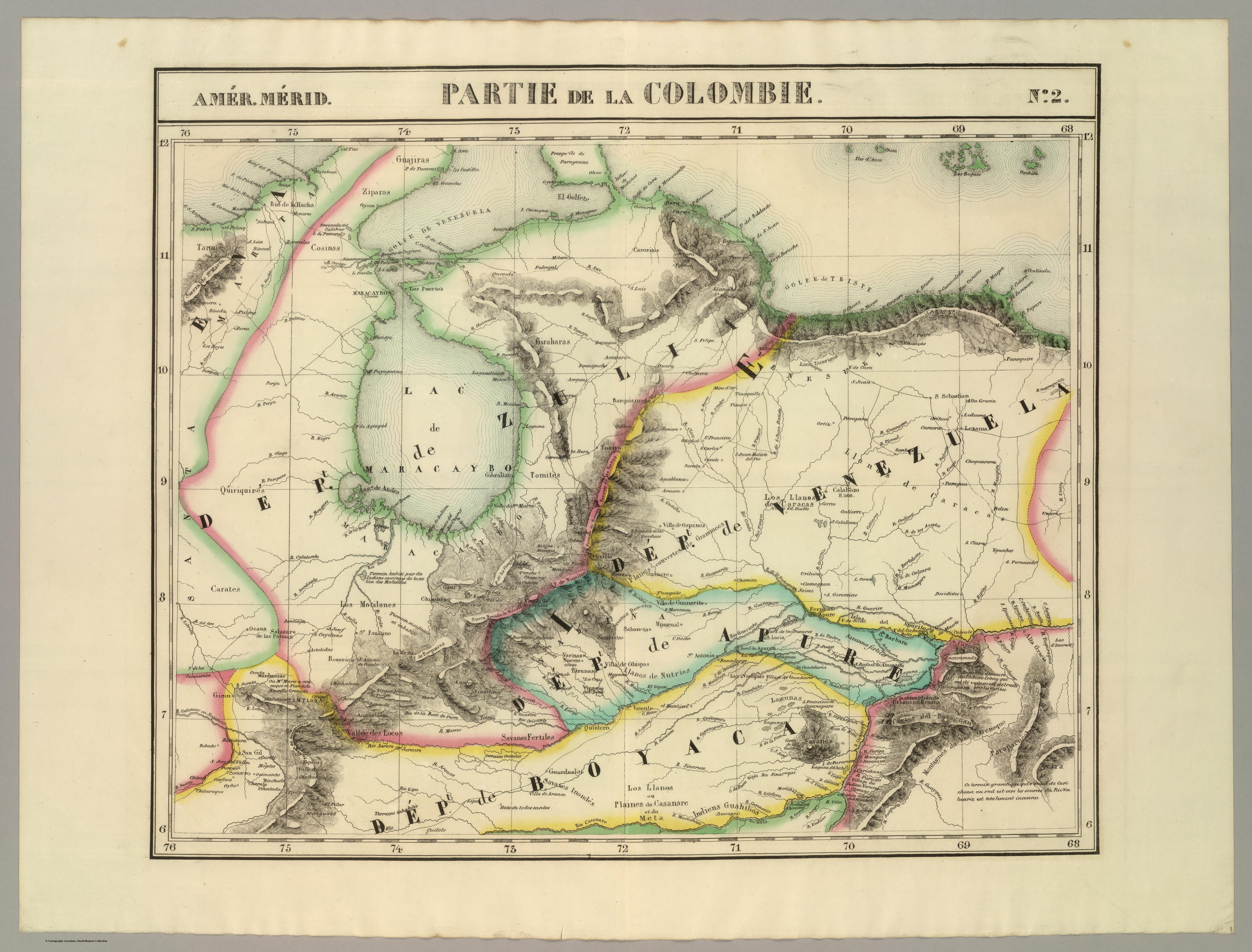
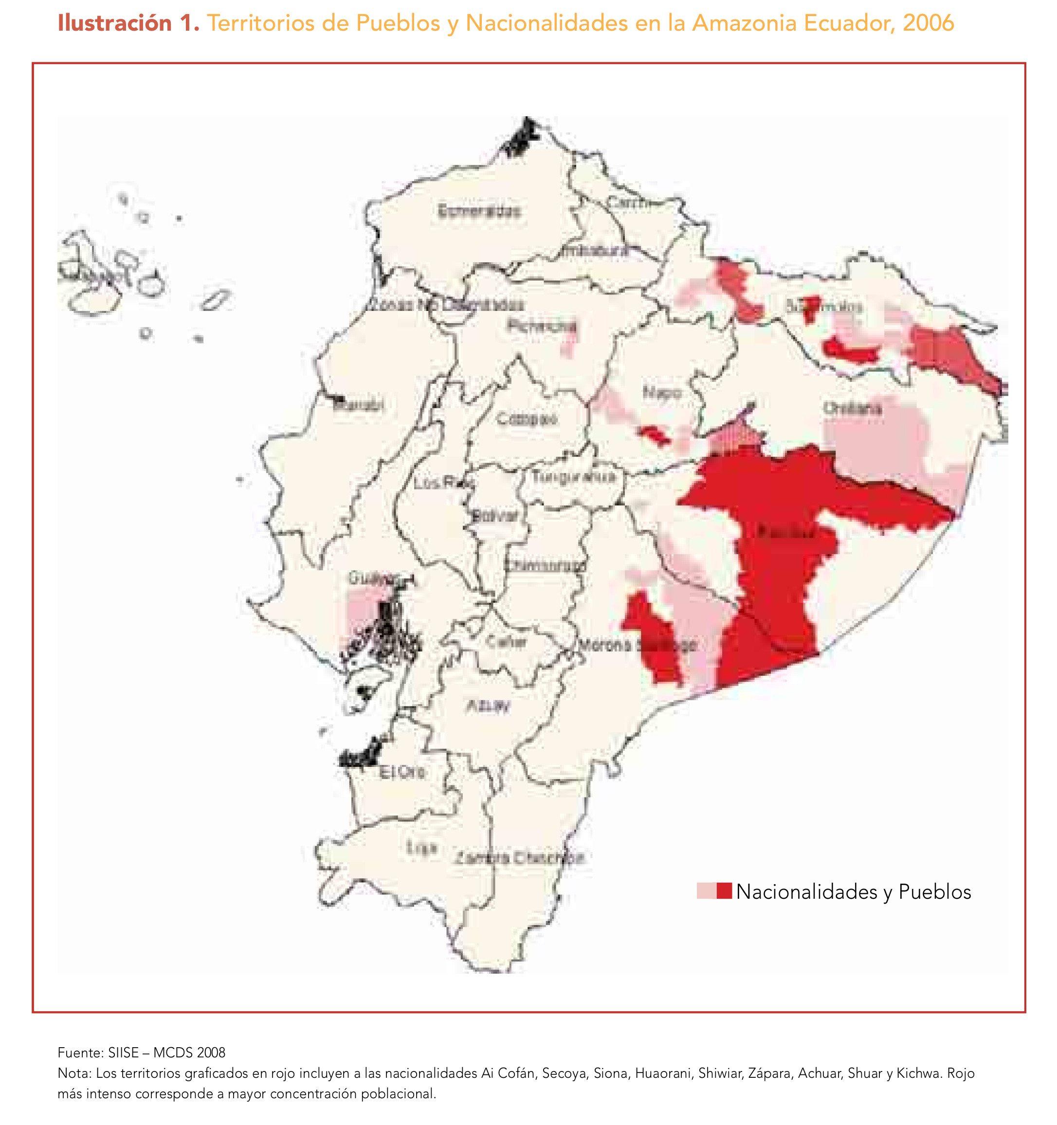
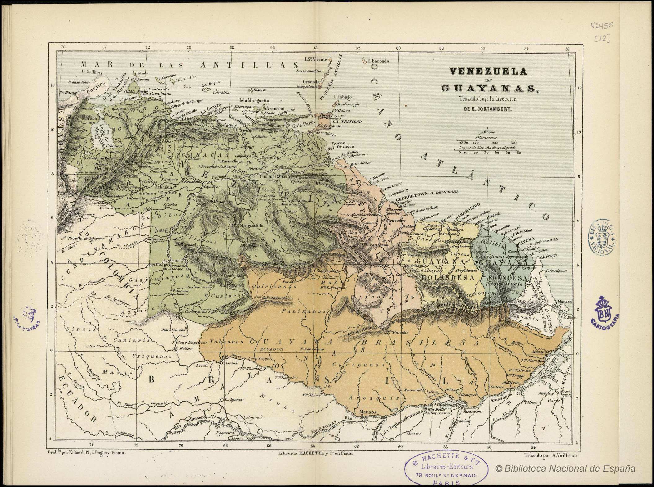
Dispossesions in the Americas

Dispossesions in the Americas

  • Home
  • Explore
  • About
  • Authors
  • Art
  • Bodies
  • Curricula
  • Cultural Heritage
  • Maps
  • Territories
Back to Explore
Map 1800 - 1899

VENEZUELA Y GUAYANAS

  • CORTAMBERT;EUGÈNE

Published: ND

  • Download Image

Peoples

  • GUARUANA
  • ARAWAK
  • CARIBE
  • WAIKAS
  • ARNACOTO
  • PURIGOTOS
  • PIAROA
  • MACOS
  • AYANOS
  • MAIPURE
  • JIVI
  • AZANENI
  • GUAIPUNAYOS
  • YE'KUANA
  • YABANOS
  • CURIARANAS
  • KIRISHANA
  • MAKUSHI
  • GALIBIS
  • TOUCAS
  • OURAGAS
  • SIROAS
  • TARUMAS
  • RONCOUYENUE
  • POUPOUROUIS
  • ACOQUAS
  • OVAMPIS
  • CUSARIS
  • URIQUENAS
  • MACUS
  • CANIARIS
  • ATORAS
  • GUACABAYAS
  • PANIXANAS
  • CARIPUNAS
  • AROAQUIS
  • MANAOS

Citation

Cortambert, Eugène. "Venezuela y Guayanas." Map. In Pequeño atlas de Geografía Moderna, 28. París: Librería de Hachette y Cía, n.d. Accessed January 2, 2023. http://bdh.bne.es/bnesearch/detalle/bdh0000000261.

  • Download Image

Reading in Spanish

Map 1800 - 1899

VENEZUELA Y GUAYANAS

  • CORTAMBERT;EUGÈNE

Published: ND

  • Download Image
  • Download Image

Related Content

Conversion of Ejidos into Private Property, Sajcabaja and Jocotenango, Guatemala, Late 18th Century through 19th Century

Conversion of Ejidos into Private Property, Sajcabaja and Jocotenango, Guatemala, Late 18th Century through 19th Century

Map 1700 - 1800
Accuratissima Brasiliae Tabula

Accuratissima Brasiliae Tabula

Map 1600 - 1699
PRINCIPALES PALENQUES DEL CARIBE

PRINCIPALES PALENQUES DEL CARIBE

Map 1600 - 1699
INTENDENCIA DE MÉXICO

INTENDENCIA DE MÉXICO

Map 1800
Territorio Rama y Kriol: Mapa de Zonas Territoriales. Three Zones proposed by the PADA to ensure a sustainable future for the communities of Rama and Kriol

Territorio Rama y Kriol: Mapa de Zonas Territoriales. Three Zones proposed by the PADA to ensure a sustainable future for the communities of Rama and Kriol

Map 2000
CONCENTRACIÓN DE POBLACION DE TRES Y MAS ANOS QUE HABLAN LENGUA INDÍGENA EN MÉRIDA, YUCATÁN, 2010

CONCENTRACIÓN DE POBLACION DE TRES Y MAS ANOS QUE HABLAN LENGUA INDÍGENA EN MÉRIDA, YUCATÁN, 2010

Map 2012
Mapa geográfico de la mayor parte de la América Meridional que contiene los paises por donde debe trazarse la línia divisoria que divida los dominios de España y Portugal: construido en virtud de real órden por el teniente general Dn. Francisco Requena

Mapa geográfico de la mayor parte de la América Meridional que contiene los paises por donde debe trazarse la línia divisoria que divida los dominios de España y Portugal: construido en virtud de real órden por el teniente general Dn. Francisco Requena

Map 1796
Traça de la conquista del capitán Diego Palomino

Traça de la conquista del capitán Diego Palomino

Map 1549

Dispossessions in the Americas

A project by

University of Pennsylvania

Copyright 2024

With support from

Mellon Foundation

Site design & development

Element 84

Art Credits

Cortambert, Eugène. “Venezuela y Guayanas.” Map. In Pequeño atlas de Geografía Moderna, 28. París: Librería de Hachette y Cía, n.d. Accessed January 2, 2023. http://bdh.bne.es/bnesearch/detalle/bdh0000000261.

Site Pages

  • Home
  • Explore
  • About
  • Authors
  • Art
  • Bodies
  • Curricula
  • Cultural Heritage
  • Maps
  • Territories