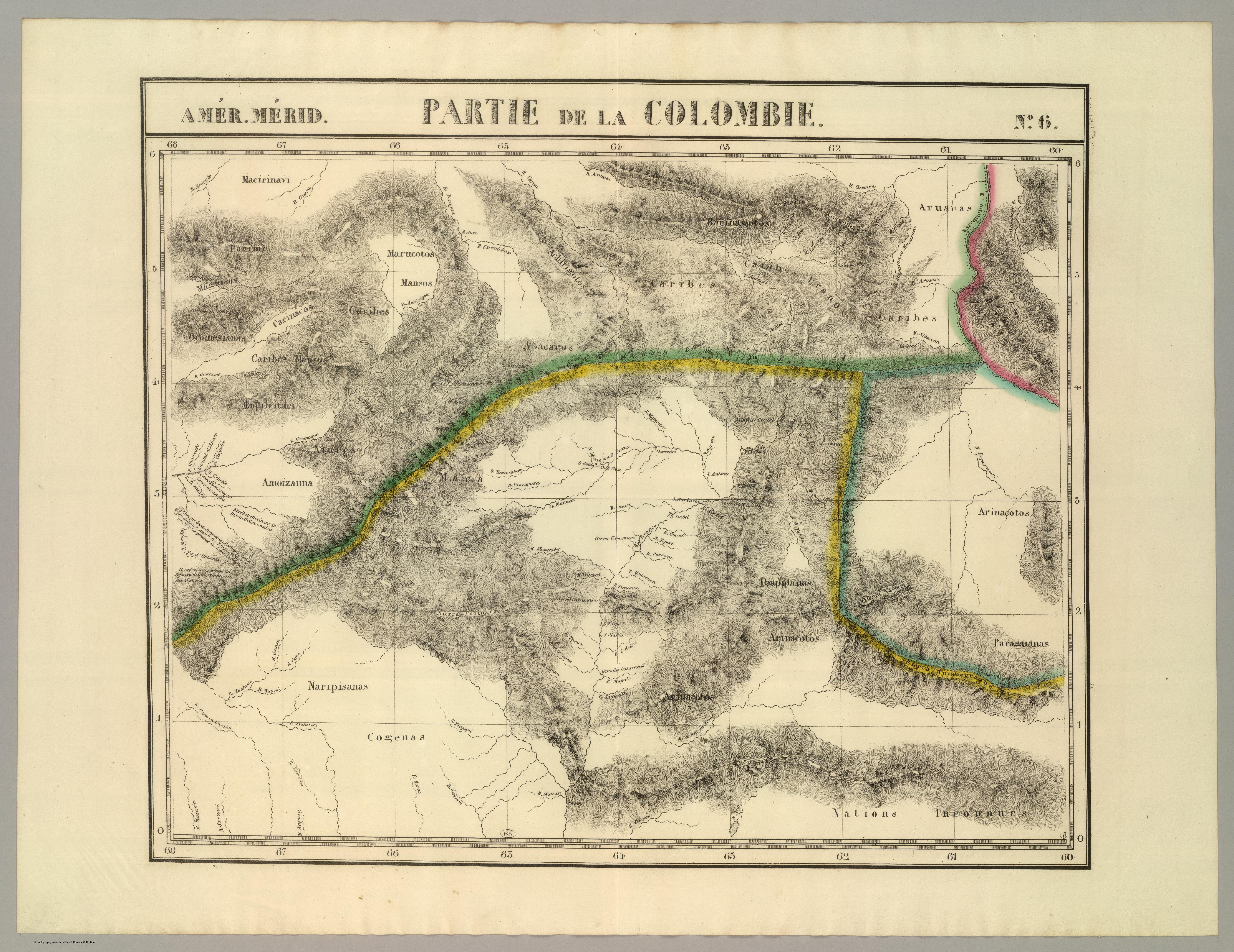
Dispossesions in the Americas

Dispossesions in the Americas

  • Home
  • Explore
  • About
  • Authors
  • Art
  • Bodies
  • Curricula
  • Cultural Heritage
  • Maps
  • Territories
Back to Explore
Map 1776

Carta del Virreynato de Santafe de Bogota: Copia de la de Mr. D'Anville

    Published: 1796

    • Download Image

    Peoples

    • QUAQUAS
    • ANDARIES
    • XIPIXAPA
    • XIBARO
    • ORONIES
    • URABA
    • ZINU
    • ACHAGUAS
    • ANDAJIES
    • ANAGUAJES
    • ABIJIRAS
    • YXINOSOS
    • ROAMAYNAS
    • XEBEROS
    • MAYONUNAS
    • PAYAGUAS
    • OROMIRA
    • OMAGUAS
    • CAVACHIS
    • PEVAS
    • ACANEJOS
    • ABANOS
    • MOTILONES
    • QUIRIQUIRES
    • SARURAS
    • SALIVAS
    • MAYPURES
    • ORELLUDOS
    • YURIMAGUAS
    • MANAOS
    • OTOMACAS
    • PAOS
    • GUAJIRO

    Citation

    Archivo Cartográfico de Estudios Geográficos del Centro Geográfico del Ejército — Ubicación: AR — Signatura: Ar.J-T.7-C.1_9 — Código de barras: 2201365 https://bibliotecavirtual.defensa.gob.es/BVMDefensa/es/consulta/registro.do?id=91578

    • Download Image

    Reading in Spanish

    Map 1776

    Carta del Virreynato de Santafe de Bogota: Copia de la de Mr. D'Anville

      Published: 1796

      • Download Image
      • Download Image

      Related Content

      San Marcos

      San Marcos

      Map 1997
      PARTIE DE LA COLOMBIE

      PARTIE DE LA COLOMBIE

      Map 1827
      Indigenous Peoples of Nicaragua: Showing traditional lands of seven currently recognized people and groups.

      Indigenous Peoples of Nicaragua: Showing traditional lands of seven currently recognized people and groups.

      Map 2022
      DISTRIBUCION DE GRUPOS CHIBCHAS MENCIONADOS EN EL TEXTO

      DISTRIBUCION DE GRUPOS CHIBCHAS MENCIONADOS EN EL TEXTO

      Map 2019
      RELACIONES GEOGRÁFICAS DE OAXACA, TEHUANTEPEC

      RELACIONES GEOGRÁFICAS DE OAXACA, TEHUANTEPEC

      Map 1579 - 1585
      Part of the Southwest 1600-1750 Showing Locations of "Unknown Athapaskans"

      Part of the Southwest 1600-1750 Showing Locations of "Unknown Athapaskans"

      Map 1600 - 1750
      No Title

      No Title

      Map 1720
      The Caribee Islands and Guyana.

      The Caribee Islands and Guyana.

      Map 1700 - 1799

      Dispossessions in the Americas

      A project by

      University of Pennsylvania

      Copyright 2024

      With support from

      Mellon Foundation

      Site design & development

      Element 84

      Art Credits

      Archivo Cartográfico de Estudios Geográficos del Centro Geográfico del Ejército — Ubicación: AR — Signatura: Ar.J-T.7-C.1_9 — Código de barras: 2201365 https://bibliotecavirtual.defensa.gob.es/BVMDefensa/es/consulta/registro.do?id=91578

      Site Pages

      • Home
      • Explore
      • About
      • Authors
      • Art
      • Bodies
      • Curricula
      • Cultural Heritage
      • Maps
      • Territories