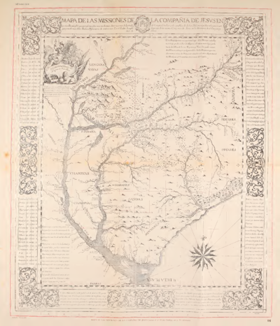
Dispossesions in the Americas

Dispossesions in the Americas

  • Home
  • Explore
  • About
  • Authors
  • Art
  • Bodies
  • Curricula
  • Cultural Heritage
  • Maps
  • Territories
Back to Explore
Map 1732

Paraguariæ Provinciæ soc. jesu cum adiacentibg. novissima descriptio : post iteratas peregrinationes & plures observationes patrum missionariorum eiusdem soc. tum huius provinciæ;cum & Peruanæ accuratissime delineata & emendata ann. 1732

  • Giovanni Petroschi

Published: 1732

  • Download Image

Peoples

  • BAVRES
  • YTONAMAS
  • GUARAYOS
  • TAPACURAS
  • CHIQUITOS
  • XAREYES
  • OREJONES
  • CHARRUAS
  • YAROS
  • BOHANES
  • MARTIDANES
  • MANCHADOS
  • ABIPONES
  • YUANES
  • LULES
  • GUAYCURUS
  • LENGUAS
  • YAYAS
  • CHOROMOROS
  • GUANAES
  • IURUCARES
  • RACHES
  • CHIRIBAS
  • RAMANOS
  • CHUMANOS
  • TOROMONAS

Citation

Library of Congress Geography and Map Division, G5200 1732 .R4 http://hdl.loc.gov/loc.gmd/g5200.br000088

  • Download Image

Reading in Spanish

Map 1732

Paraguariæ Provinciæ soc. jesu cum adiacentibg. novissima descriptio : post iteratas peregrinationes & plures observationes patrum missionariorum eiusdem soc. tum huius provinciæ;cum & Peruanæ accuratissime delineata & emendata ann. 1732

  • Giovanni Petroschi

Published: 1732

  • Download Image
  • Download Image

Related Content

A MAP of the CARACAS

A MAP of the CARACAS

Map 1818
CARTE DE LA DEPENDANCE DU YAPOK JUSQU'A la Riviere des Amazones

CARTE DE LA DEPENDANCE DU YAPOK JUSQU'A la Riviere des Amazones

Map 1737
Het Goudryk gewest Guiana tot de Drywerfze Scheepstogten.

Het Goudryk gewest Guiana tot de Drywerfze Scheepstogten.

Map 1700 - 1799
NEW GRANADA

NEW GRANADA

Map 1811
Nova et Accurate BRASILIAE totius TABULA

Nova et Accurate BRASILIAE totius TABULA

Map 1700 - 1745
MAPA DE LAS MISSIONES DE LA COMPANIA DE JESVS EN

MAPA DE LAS MISSIONES DE LA COMPANIA DE JESVS EN

Map 1749
The Spanish and Musketor shore and the bay of Honduras and the islands adjacent

The Spanish and Musketor shore and the bay of Honduras and the islands adjacent

Map 1735
COLOMBIE;GUYANE;VENEZUELA;ÉQUATEUR

COLOMBIE;GUYANE;VENEZUELA;ÉQUATEUR

Map 1868

Dispossessions in the Americas

A project by

University of Pennsylvania

Copyright 2024

With support from

Mellon Foundation

Site design & development

Element 84

Art Credits

Library of Congress Geography and Map Division, G5200 1732 .R4 http://hdl.loc.gov/loc.gmd/g5200.br000088

Site Pages

  • Home
  • Explore
  • About
  • Authors
  • Art
  • Bodies
  • Curricula
  • Cultural Heritage
  • Maps
  • Territories