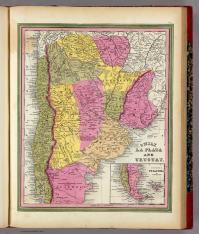
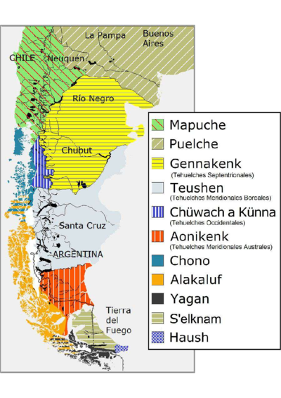
Dispossesions in the Americas

Dispossesions in the Americas

  • Home
  • Explore
  • About
  • Authors
  • Art
  • Bodies
  • Curricula
  • Cultural Heritage
  • Maps
  • Territories
Back to Explore
Map 1853 - 1856

Map of the basin of La Plata : based upon the results of the expedition under the command of Thos. J. Page;U.S. Navy;in the years 1853;-'54;-'55;& 56 and of the adjacent countries

  • Thomas Jefferson Page;Julius Bien

Published: 1856

  • Download Image

Peoples

  • CHIQUITOS
  • GUAYCURUS
  • MOCOBIOS
  • ABIPONES
  • CHIRIGUANO
  • TOBAS

Citation

Library of Congress Geography and Map Division, G5202.R5 1856 .P3 https://hdl.loc.gov/loc.gmd/g5202r.fi000158

  • Download Image

Reading in Spanish

Map 1853 - 1856

Map of the basin of La Plata : based upon the results of the expedition under the command of Thos. J. Page;U.S. Navy;in the years 1853;-'54;-'55;& 56 and of the adjacent countries

  • Thomas Jefferson Page;Julius Bien

Published: 1856

  • Download Image
  • Download Image

Related Content

Mapa de la Ciudad de Valdivia y territorios de sus cercanías

Mapa de la Ciudad de Valdivia y territorios de sus cercanías

Map 1785
PARAGUAY

PARAGUAY

Map
PUEBLO CHOL

PUEBLO CHOL

Map 2020
CHILE LA PLATA AND URUGUAY

CHILE LA PLATA AND URUGUAY

Map 1836
Mapa VI.1 Familias lingüísticas en el área de Orinoquía

Mapa VI.1 Familias lingüísticas en el área de Orinoquía

Map 2009
PUEBLO Q'ANJOB'AL

PUEBLO Q'ANJOB'AL

Map 2020
BRASIL

BRASIL

Map 1700 - 1799
Haush Indians of Tierra del Fuego

Haush Indians of Tierra del Fuego

Map 1800

Dispossessions in the Americas

A project by

University of Pennsylvania

Copyright 2024

With support from

Mellon Foundation

Site design & development

Element 84

Art Credits

Library of Congress Geography and Map Division, G5202.R5 1856 .P3 https://hdl.loc.gov/loc.gmd/g5202r.fi000158

Site Pages

  • Home
  • Explore
  • About
  • Authors
  • Art
  • Bodies
  • Curricula
  • Cultural Heritage
  • Maps
  • Territories