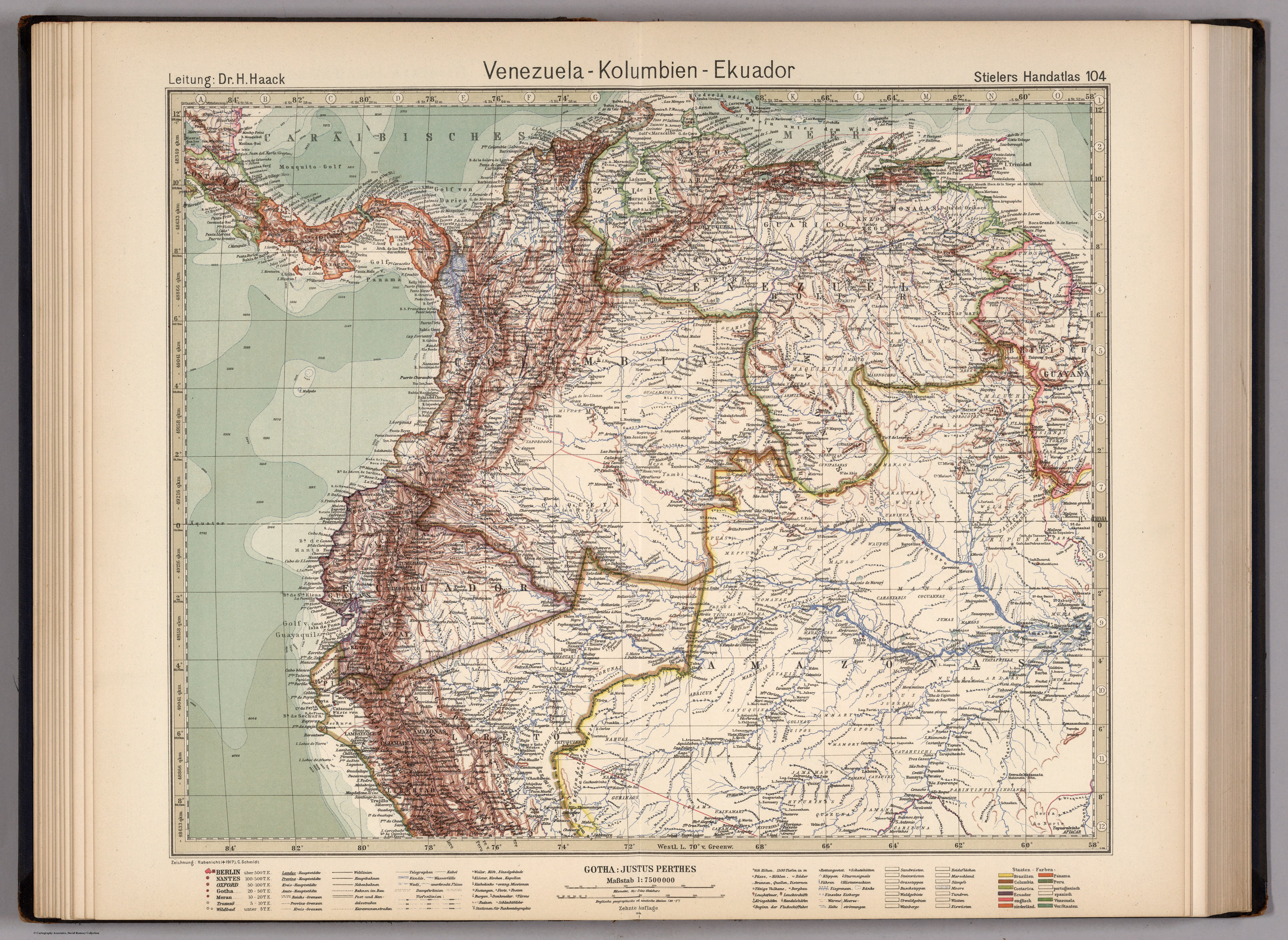
Dispossesions in the Americas

Dispossesions in the Americas

  • Home
  • Explore
  • About
  • Authors
  • Art
  • Bodies
  • Curricula
  • Cultural Heritage
  • Maps
  • Territories
Back to Explore
Map 1924

VENEZUELA - KOLUMBIEN – EKUADOR

  • HAACK;H. ET AL.

Published: 1925

  • Download Image

Peoples

  • TALAMANCA
  • GUARAUNOS
  • TAPARITO
  • GUAHIBOS
  • PIAROA
  • MAQUIRITARE
  • YOCURAS
  • MACOS
  • CADUPINAPOS
  • MAVITZI
  • MAIONGCONG
  • ARINAGOTOS
  • MAUCUS
  • WAICAS
  • AREK
  • WAPISIANAS
  • ATORAIS
  • TARUMAS
  • MACUCHIS
  • POROCOTOS
  • CURIARANAS
  • ABIRIANOS
  • PIAPOCOS
  • GUACAMAYOS
  • MITUAS
  • YAPOROGOS
  • YABANOS
  • CUNIPASANAS
  • OREMANAOS
  • BABAUANAS
  • CARAHYABY
  • UARIHUA
  • JAUAPERYS
  • CRICHANAS
  • SIRICUMES
  • CARIPUNAS
  • TARACUM
  • WAUPES
  • MANAO
  • MACU
  • MEPPURIS
  • JAPUAS
  • OMAGUAS
  • PASSES
  • TICUNAS
  • MIRANHA
  • XOMANAS
  • CAUIXANAS
  • MARAUAS
  • COCUANNAS
  • JUMAS
  • MURAS
  • ITATAPRIYAS
  • ARARAS
  • PURUS
  • JUBERIS
  • PAMMARY
  • GOLINAS
  • CATAUIX
  • MARAUNAS
  • CATUQUINA
  • ABAICUS
  • MAYORUNAS
  • COCAMAS
  • PIROS
  • AGUARUNAS
  • JIBAROS
  • SETEBOS
  • CONIBOS
  • PANOS
  • REMOS
  • CAPANAGUAS
  • NAHUAS
  • CIPOS
  • JAMAMADY
  • MAMORY
  • PAMANA
  • CATAUIXI
  • CATAHUICHI
  • PARINTINTIN-INDIANER
  • QUARUNA
  • HYPURINAS
  • CANAMARY
  • UAINAMARY
  • GURINAOS

Citation

Stieler, Adolf, and H. Haack. Venezuela - Kolumbien - Ekuador. Map. Gotha: Justus Perthes, 1925. Accessed December 23, 2022. https://www.davidrumsey.com/luna/servlet/detail/RUMSEY~8~1~265694~90040013:104--VEN---Kolumbien---Ekuado?sort=pub_list_no_initialsort%2Cpub_list_no_initialsort%2Cpub_date%2Cpub_date.

  • Download Image

Reading in Spanish

Map 1924

VENEZUELA - KOLUMBIEN – EKUADOR

  • HAACK;H. ET AL.

Published: 1925

  • Download Image
  • Download Image

Related Content

The Geography of Peninsular Languages

The Geography of Peninsular Languages

Map 1994
Pueblos indígenas en el Perú amazónico

Pueblos indígenas en el Perú amazónico

Map 2009
CARTE DE LA DEPENDANCE DU YAPOK JUSQU'A la Riviere des Amazones

CARTE DE LA DEPENDANCE DU YAPOK JUSQU'A la Riviere des Amazones

Map 1737
MAPA DE CUAUHTINCHAN N0. 2

MAPA DE CUAUHTINCHAN N0. 2

Map 1500 - 1599
Mapa de las culturas indígenas en vísperas de la conquista española.

Mapa de las culturas indígenas en vísperas de la conquista española.

Map 1650 - 1750
Carte des colonies Française et Hollandaise de la Guyane Dressée d'après les cartes de N. Buache et de S. Mentelle Capitaine d'Infanterie

Carte des colonies Française et Hollandaise de la Guyane Dressée d'après les cartes de N. Buache et de S. Mentelle Capitaine d'Infanterie

Map 1800 - 1899
SONORA

SONORA

Map 2015
Carte de la Guyane françoise depuis le cap de Nord jusqu'à la R. de Maroni, par le S.r D anville

Carte de la Guyane françoise depuis le cap de Nord jusqu'à la R. de Maroni, par le S.r D anville

Map 1729

Dispossessions in the Americas

A project by

University of Pennsylvania

Copyright 2024

With support from

Mellon Foundation

Site design & development

Element 84

Art Credits

Stieler, Adolf, and H. Haack. Venezuela - Kolumbien - Ekuador. Map. Gotha: Justus Perthes, 1925. Accessed December 23, 2022. https://www.davidrumsey.com/luna/servlet/detail/RUMSEY~8~1~265694~90040013:104--VEN---Kolumbien---Ekuado?sort=pub_list_no_initialsort%2Cpub_list_no_initialsort%2Cpub_date%2Cpub_date.

Site Pages

  • Home
  • Explore
  • About
  • Authors
  • Art
  • Bodies
  • Curricula
  • Cultural Heritage
  • Maps
  • Territories