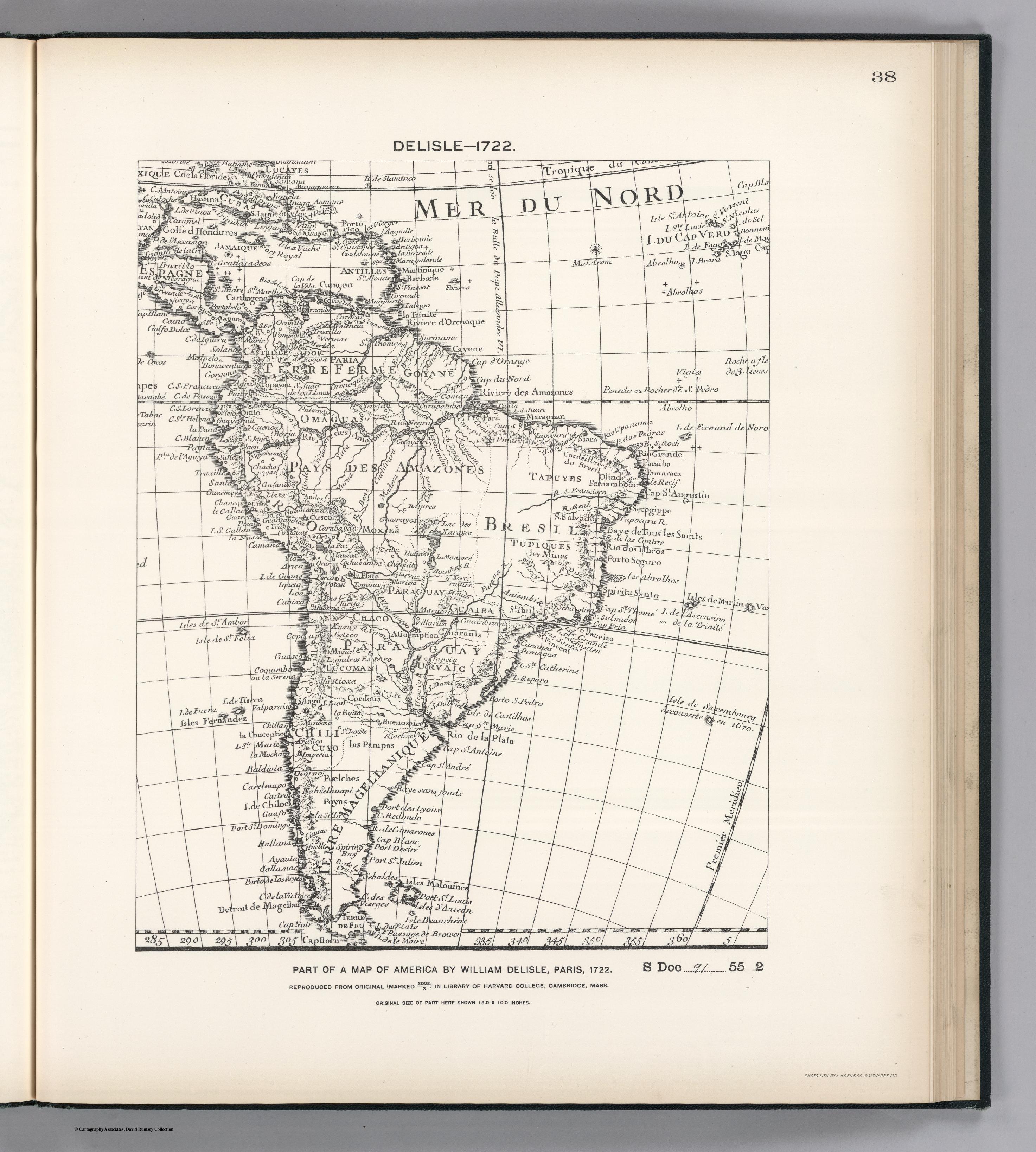
Dispossesions in the Americas

Dispossesions in the Americas

  • Home
  • Explore
  • About
  • Authors
  • Art
  • Bodies
  • Curricula
  • Cultural Heritage
  • Maps
  • Territories
Back to Explore
Map 1722

FACSIMILE PART OF AMERICA BY DELISLE

  • WILLIAM DELISLE

Published: 1897

  • Download Image

Peoples

  • OMAGUAS
  • TAPUYES
  • MOXES
  • TUPIQUES
  • ITATINES
  • COLAGUAS
  • GUARAYOS
  • CHIQUITO
  • GUARANIS
  • PAMPAS
  • PUELCHES
  • POYAS

Citation

Delisle, William. Facsimile Part of America by Delisle. Map. Washington, D.C.: United States of America, 1722. Accessed October 30, 2022. https://www.davidrumsey.com/luna/servlet/detail/RUMSEY~8~1~203994~3001757:Facsimile-Part-of-America-by-Delisl?sort=pub_list_no_initialsort%2Cpub_date%2Cpub_list_no%2Cseries_no#.

  • Download Image

Reading in Spanish

Map 1722

FACSIMILE PART OF AMERICA BY DELISLE

  • WILLIAM DELISLE

Published: 1897

  • Download Image
  • Download Image

Related Content

ESTADOS UNIDOS DO BRAZIL

ESTADOS UNIDOS DO BRAZIL

Map 1902
Tribus del Gran Chaco

Tribus del Gran Chaco

Map 1527 - 1790
Copia del Plano Topográfico de la Ciudad de Lima, capital del Perú, y de su presidio y puerto del Callao, que como última observación de Latitud Austral, y demarcación geográfica de las costas de Chile y del Perú

Copia del Plano Topográfico de la Ciudad de Lima, capital del Perú, y de su presidio y puerto del Callao, que como última observación de Latitud Austral, y demarcación geográfica de las costas de Chile y del Perú

Map 1712
Amerique Meridionale

Amerique Meridionale

Map 1600 - 1699
GUARANÍ OCCIDENTAL

GUARANÍ OCCIDENTAL

Map 2015
La France. Amérique Française (Guyane). Afrique Française (Illes S.te Marie, Nossi-bé, Nossi-cumba, Nossi-fali &.).

La France. Amérique Française (Guyane). Afrique Française (Illes S.te Marie, Nossi-bé, Nossi-cumba, Nossi-fali &.).

Map 1869
Geographical Distribution of the Huave

Geographical Distribution of the Huave

Map 1969
MAPA O CARTA GEOGRÁFICA DE LA PROVINCIA DE VENEZUELA. LA CAPITAL ES LA CIUDAD DE SANTIAGO DE LÉON DE CARACAS.

MAPA O CARTA GEOGRÁFICA DE LA PROVINCIA DE VENEZUELA. LA CAPITAL ES LA CIUDAD DE SANTIAGO DE LÉON DE CARACAS.

Map 1780

Dispossessions in the Americas

A project by

University of Pennsylvania

Copyright 2024

With support from

Mellon Foundation

Site design & development

Element 84

Art Credits

Delisle, William. Facsimile Part of America by Delisle. Map. Washington, D.C.: United States of America, 1722. Accessed October 30, 2022. https://www.davidrumsey.com/luna/servlet/detail/RUMSEY~8~1~203994~3001757:Facsimile-Part-of-America-by-Delisl?sort=pub_list_no_initialsort%2Cpub_date%2Cpub_list_no%2Cseries_no#.

Site Pages

  • Home
  • Explore
  • About
  • Authors
  • Art
  • Bodies
  • Curricula
  • Cultural Heritage
  • Maps
  • Territories