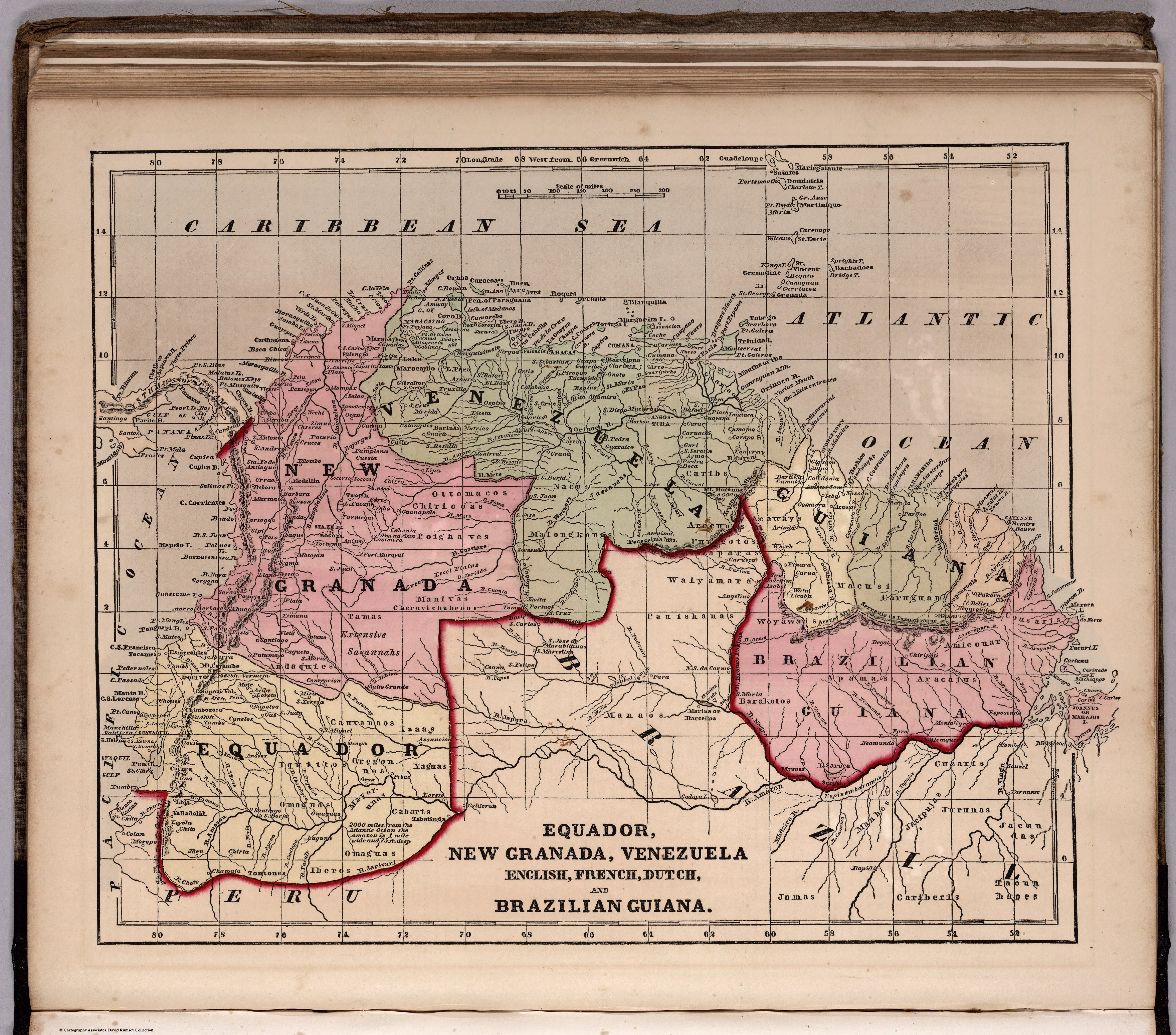
Dispossesions in the Americas

Dispossesions in the Americas

  • Home
  • Explore
  • About
  • Authors
  • Art
  • Bodies
  • Curricula
  • Cultural Heritage
  • Maps
  • Territories
Back to Explore
Map 1800 - 1899

ECUADOR;NEW GRANADA;VENEZUELA;AND GUIANA.

  • MORSE;CHARLES;ET AL.

Published: 1856

  • Download Image

Peoples

  • GUARUANA
  • CARIBE
  • ARECUNAS
  • PURIGOTOS
  • ZAPARA
  • MAIONGEONG
  • OTOMACO
  • MAKUSHI
  • CHIRICOA
  • ACAWAYS
  • WAIYAMARAS
  • CARUGUANI
  • PAUSHANAS
  • COUSARIS
  • AMICOUAR
  • ARACAJUS
  • WOYAWAI
  • BARAKOTOS
  • MANAOS
  • CUZARIS
  • JURUNAS
  • JACANDAS
  • TAOUNHANES
  • CARIBERIS
  • JACIPUJAZ
  • MANHES
  • JUMAS
  • POIGHAVES
  • MANIVAS
  • CHERUVICHAHENAS
  • TAMAS
  • ANDAQUIES
  • IZAAS
  • CAUXANAOS
  • IQUITOS
  • OREGONOS
  • YAGUAS
  • MAYORUNAS
  • CABARIS
  • OMAGUAS
  • IBEROS
  • TONTONES

Citation

Morse, Charles W., and Charles A. Colby. Ecuador, New Granada, Venezuela, and Guiana. Map. New York: D. Appleton & Co., 1856. Accessed October 13, 2022. https://www.davidrumsey.com/luna/servlet/detail/RUMSEY~8~1~268938~90041135:ECU,-New-Granada,-VEN,-an?sort=pub_list_no_initialsort%2Cpub_date%2Cpub_list_no%2Cseries_no#.

  • Download Image

Reading in Spanish

Map 1800 - 1899

ECUADOR;NEW GRANADA;VENEZUELA;AND GUIANA.

  • MORSE;CHARLES;ET AL.

Published: 1856

  • Download Image
  • Download Image

Related Content

Le Paraguay Tiré des Relations les plus Recentes

Le Paraguay Tiré des Relations les plus Recentes

Map 1668
No Title

No Title

Map 1791
REGIÓN PUREPECHA

REGIÓN PUREPECHA

Map 2000
CARTA ETNOGRÁFICA DE MEXICO

CARTA ETNOGRÁFICA DE MEXICO

Map 1864
REGIÓN CHINANTECA

REGIÓN CHINANTECA

Map 2000
Ilustración 1. Territorios de Pueblos y Nacionalidades en la Amazon Ecuador;2006

Ilustración 1. Territorios de Pueblos y Nacionalidades en la Amazon Ecuador;2006

Map 2006
Sistema guatemalteco de áreas protegidas (SIGAP) y sitios arqueológicos en 2000.

Sistema guatemalteco de áreas protegidas (SIGAP) y sitios arqueológicos en 2000.

Map 2000
Tribes of the Gran Chaco: Present day locations

Tribes of the Gran Chaco: Present day locations

Map 1946

Dispossessions in the Americas

A project by

University of Pennsylvania

Copyright 2024

With support from

Mellon Foundation

Site design & development

Element 84

Art Credits

Morse, Charles W., and Charles A. Colby. Ecuador, New Granada, Venezuela, and Guiana. Map. New York: D. Appleton & Co., 1856. Accessed October 13, 2022. https://www.davidrumsey.com/luna/servlet/detail/RUMSEY~8~1~268938~90041135:ECU,-New-Granada,-VEN,-an?sort=pub_list_no_initialsort%2Cpub_date%2Cpub_list_no%2Cseries_no#.

Site Pages

  • Home
  • Explore
  • About
  • Authors
  • Art
  • Bodies
  • Curricula
  • Cultural Heritage
  • Maps
  • Territories